WCG - Mt. Briar Wetlands Traditional Geocache
-
Difficulty:
-

-
Terrain:
-

Size:  (regular)
Please note Use of geocaching.com services is subject to the terms and conditions
in our disclaimer.
The Washington County GeoTrail
WCG - Mt Briar Wetland Preserve

The Washington County GeoTrail (WCG) launched on Saturday, September 14, 2013. The Trail consists of over thirty-five (35) geocaches placed at points of interest all over the County. Caches will be found in National, State, County and Town parks as well as at museums, wineries, historical sites and places of natural beauty. A trackable geocoin was awarded to the first 500 geocachers who completed the Washington County Geotrail. The original allotment of Coins has been exhausted and new parameters to receive the updated Coin are below.
To be eligible for the coin, GeoCachers may download the Washington County GeoTrail passport online at www.visitHAGERSTOWN.com or pick one up in person at the Visitor Welcome Center at 6 N. Potomac Street. Completed passports may be verified on site at the above address or by mail.
Please note the following Change. Washington County GeoCoins will be available for purchase at the Visitor Welcome Center for GeoCachers who log 20 or more caches on the Washington County GeoTrail. The cost of the GeoCoin will be $10. An additional $3.50 shipping charge will apply for passports redeemed by mail. For more information about geocaching in Washington County and the full complement of local amenities, the above links are your gateway to historically beautiful Washington County!
Participating in the WCG geotrail is fun and we hope that many people join in. However, it is not a requirement for logging your find on this cache once you find the container.
WCG – Mt. Briar Wetlands
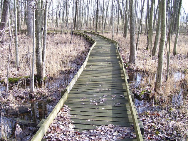
One of Maryland's most unique non-tidal wetlands, thirty-acre Mt. Briar Wetlands is located along Millbrook Road of Maryland Route #67 near Rohrersville. The Preserve contains approximately one mile of floating boardwalks.
Wetlands are areas that are periodically or permanently inundated by surface or ground water and support plant and animal species adapted to life in saturated soils.
The wetland preserve contains both deciduous woodland and an upland grassy meadow. Water emerges from seepage springs at the north end of the preserve. Despite the lack of a natural stream, water flows through the upper layers of substrata causing the soil's saturation.
A field study done in 1984 identified 29 tree species, 81 species of grass, 16 shrubs and vines, 4 moss species, 36 bird species, and numerous reptile, insect, and animal life. This wetland is a wonderful location for watching birds and animals.
Wetlands are extremely sensitive to disturbance by humans. For this reason, it is important and essential that visitors remain on the boardwalks.
This cache is placed with permission of the Washington County Parks Department. Visit times are dawn to dusk. Please stay on the Boardwalks. Walk-in traffic IS allowed when the gates are closed. Be aware that there is limited parking. The cache is regular in size.

The Washington County GeoTrail wishes to Thank the Hagerstown Washington County Convention and Visitors Bureau for their timely and continuing assistance with this Washington County adventure.

The WCG also wishes to thank the following geocachers who spent countless hours in planning and deploying the caches – ALs Guide, Always Lost 00, Kitakima, LPYankeefan, nomaland, Snurt, tazscouter, and tiger77aam.

Additional Hints
(Decrypt)
JBBQRA CNYNPR