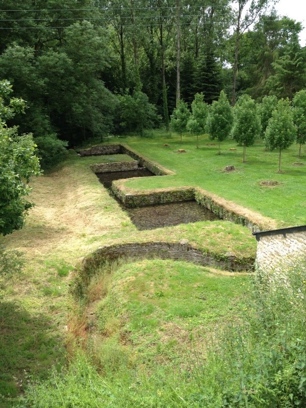
 Rolland de Dinan a fondé l'abbaye "Notre Dame du Pont Pilard" vers 1160, c'est son successeur Alain de Vitré qui l'a renommé "Abbaye de Beaulieu". Elle abritait à l'époque huit chanoines réguliers de l'ordre de Saint Augustin. Les deux fondateurs ont été enterré dans l'église abbatiale, puis leurs gisants ont été déplacés au musée de Dinan pour Rolland et dans le cloître de la cathédrale de Tréguier pour Alain.
Pendant les guerres civiles de la fin du 14e siècle l'abbaye est pillée par les huguenots. Puis en 1791 plus de 500 personnes détruisent une grande partie des écrits et menacent de brûler un moine. Les bâtiments conventuels sont maintenant une propriété privée – le château de Beaulieu. La chapelle, accolée aux bâtiments conventuels en 1733 a été détruite au 19e siècle.
L'étang et le moulin ont été créés par Guy Le Lionnays, premier abbé commendataire de l'abbaye au 15e siècle. Les armes du fondateur sont gravées sur le pignon du moulin en dessous de celles du moine Claude Philippe Le Clerc du Tremblay. Une légende affirmait l'existence sous l'eau de profondes carrières, mais cette idée a été invalidée par un vidage de l'étang. La tradition évoque également un souterrain creusé par les moines reliant l'abbaye de Beaulieu au manoir de la Burie. La Roselais était une ancienne métairie de l'abbaye.
Garez votre voiture sur le bord de l'étang et passez sur la digue pour regarder le moulin de plus près. Observez le canal maçonné en contrebas qui permettait le tri des poissons quand on vidait l'étang. Merci de respecter les propriétés privées – il n'est pas nécessaire d'y pénétrer pour trouver les indices ou découvrir la cache.
Trouvez les nombres suivants pour calculer les coordonnées de la cache :
A = le nombre de poteaux verticaux en bois de la protection routière côté étang et ajouter 6 au nombre trouvé !
B = le nombre d'armoiries sur le pignon du moulin
C = le nombre de lions visibles (depuis la route) sur les murs du moulin
D = le nombre de conduits de cheminée d'origine du moulin
E = le nombre d'éléphants visibles sur le toit du moulin
F = le nombre de traverses en bois du banc au bout de la digue
Les coordonnées de la cache sont N 48° (A/B+B).(C+D)EE W 2° (C+F-B).E(C-D)D
--------------------------------------------------------------------------------------------------------------------------
From dam to roses
Rolland of Dinan founded the abbey "Notre Dame du Pont Pilard" about 1160, and his successor Alain de Vitre renamed it to "Beaulieu Abbey." It then housed eight monks of the Order of Saint Augustine. The two founders were buried in the abbey church, and their effigies were moved to the Museum of Dinan for Rolland and in the cloister of the Cathedral of Tréguier for Alain.
During the civil wars of the late 14th century the abbey was sacked by the Huguenots. Then in 1791 more than 500 people destroyed all documents and even threatened to burn a monk. The convent buildings are now private property - the castle of Beaulieu. The chapel adjoined to the convent buildings in 1733 was destroyed in the 19th century.
The pond and the mill were created by Guy Le Lionnays first commendatory abbot of the abbey in the 15th century. The arms of the founder are engraved on the gable of the mill below those of the monk Claude Philippe Le Clerc du Tremblay. A legend affirmed the existence of deep underwater careers, but this idea was struck by a dump of the pond. Tradition also mentions an underground dug by monks between the Abbey of Beaulieu and the mansion Burie. The Roselais was a former farm of the abbey.
Park your car on the edge of the pond and go over the dam to have a closer look at the mill. Watch the masonry canal below that allowed sorting fish when emptying the pond. Please respect private property - it is not necessary to enter it to find clues or the final cache.
Find the following numbers to calculate the coordinates of the cache:
A = the number of vertical wooden poles of the road side protection on the pond side and add 6 to the number you found!
B = the number of coats of arms on the gable of the mill
C = the number of lions visible (from the road) on the walls of the mill
D = the number of original chimneys on the mill
E = the number of elephants visible on the roof of the mill
F = the number of wooden planks of the bench at the end of the dam
The coordinates of the cache are N 48° (A/B+B).(C+D)EE W 2° (C+F-B).E(C-D)D