The Chosen Spot - Clark's Gully EarthCache
The Chosen Spot - Clark's Gully
-
Difficulty:
-

-
Terrain:
-

Size:  (other)
Please note Use of geocaching.com services is subject to the terms and conditions
in our disclaimer.
IF YOU CANNOT PROVIDE AN ELEVATION READING THAT IS WITHIN +/- 50 FT THE ACTUAL ELEVATION OF GZ, THEN DO NOT ATTEMPT THIS CACHE.
IF YOU DO NOT HAVE A THERMOMETER, THEN DO NOT ATTEMPT THIS CACHE
Find logs that are posted without answering the required four questions WILL be deleted. There will be no leniency granted to you just because you "forgot" a thermometer or did not expect to take an elevation reading. Read the entire page before your trip here. If you are expecting this to just be an easy bonus in addition to the oldie nearby, then you must come prepared.
• This is an Earthcache. There is no actual container to hunt for at the listed coordinates. Please read below as you will be learning an earth science lesson about the unique features of this particular type of area. •
Clark's Gully is located at the south end of Canandaigua Lake in the Finger Lakes section of New York. Now considered modern day Hi Tor Wildlife Management Area, it is widely believed to have been the birth place of the Seneca Indian Tribe and where they believe the world began. Ironically, in the language of the Seneca, Canandaigua means "The Chosen Spot". I would say this is a chosen spot indeed. It has been a very popular area for the Seneca to come pray over the years, however it has now formed into an eroded gully.
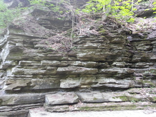
Gullies are created when running water flows down a hillside and erodes into the soil. Erosion is the process by which the earth's surface wears away due to water, metling glaciers, storms, wind and other natural disasters. The soil erodes to a point where it eventually becomes sediment. The smooth sediment you see here is caused by years of soil erosion from the water runoff. The extreme lack of soil within the gully indicates that it has been forming for a large number of years however, is still in the erosion process due to the constant running water from the nearby source. This is quite interesting, as many many years from now, this gully will likely be wider and higher in size if the water runoff continues. The runoff is said to come from the nearby Canandaigua Lake, however could be caused by rainfall, snowfall or even earthquakes.
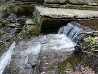
The small falls here are particularly unique because they are considered "cascade" waterfalls. Cascade "falls", by definition, are where water flows over "step-like" rocks downhill. The steps here have been primarily formed by the cool flowing water which has eroded the soil over time. You'll notice the smooth texture of the sediment indicating how it has eroded. Observe the temperature of the water and you'll notice how cool it is even in warm weather. This is likely due to the high elevation of this area and the high flow of the stream. The highest waterfalls in Clark's Gully are located further upstream, however are significantly more difficult to access. At the listed coordinates, you'll notice a large wall of rock sediment that demonstrates how much the area has eroded over the years.
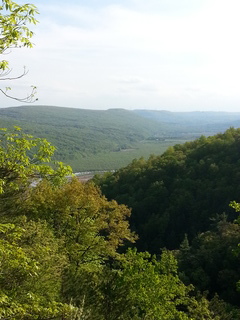
GETTING TO THIS AREA - It is suggested that you park at the listed parking coordinates, and hike in from the trailhead. It will be a very steep and strenuous hike, however, this is the most fulfilling way to access this area. Taking this route will offer some spectacular views as well, like the one pictured below.
If you access it from the other side of the area, you may not be able to pass the highest fall areas to reach the listed coordinates. Depending on recent rains, you may need to wade in deep water within the gully as well.
YOU MUST EMAIL ME VIA MY GEOCACHING.COM PROFILE WITH THE ANSWERS TO THE FOLLOWING QUESTIONS TO CLAIM THIS EARTHCACHE *ANY LOG NOT MEETING THESE REQUIREMENTS WILL PROMPTLY BE DELETED* -
1. Using a compass, tell me in which direction the water is flowing (North, South, East, West, Northeast, Northwest, Southeast, Southwest)
2. Using a thermometer, measure the temperature of the water in degrees Fahrenheit and indicate the time of year it is.
3. At the listed coordinates, you'll notice a wall of "brick-like" sediment caused by erosion. From where you are standing, how high would you say this wall is in feet?
4. At the listed coordinates, take an elevation reading and send it to me with your email.
5. OPTIONAL - Take a picture in front of one of the "falls" and post it in your log. This is not a requirement, but given how beautiful this area is, you may just want to.
| This Earthcache was placed by an: |
 |
Please keep in mind that you are hiking to this area at your own risk. I will not be responsible for any injuries you sustain while hiking to this Earthcache. During your hike you will experience steep terrain and high cliffs. Please use extra caution and bring plenty of water. This earth cache is not far from the famous GC39 "The Spot". Don't pass that one up while you're here! Please be safe and have fun!
Additional Hints
(No hints available.)