The walk to find this plane crash site starts at the the car park at the end of Kaiparoro Road. The very first thing you have to do is cross the Makakahi River so it is advisable to bring a change of dry shoes with you. Then follow the main, well-used track up to Kaiparoro trig. On the way up skindo has planted a series of caches culminating in one close to the trig. Suggest you first visit the trig then return to the bush edge to start the off-track walk to the crash site. When walking uphill, the turn off to this track (WP1) is at the last orange triangle on a tree before you leave the bush and the vegetation opens out into tussock. You will notice a faint foot trail. This trail is now well marked with permanent markers and will take you to the steep slope where the wreckage is to be found. A cross marking the grave of Flying Officer Leary will be clearly seen (WP2). The crash site is 633 metres south and 116 metres west of the Kaiparoro trig. Allow 45-60 minutes to find your way there. Out of respect the cache (a 1.2 litre sistema container) is located a short climb above the wreckage at the foot of a solitary stump that is about the height of a person.
Please respect this crash site and leave everything as you find it.
In 2002 Merv Matthews wrote an article about this crash. Excerpts from this article are reproduced with his permission.
The tragic story of Flying Officer Leary and the crash of RNZAF Oxford NZ2124 in the Tararua Ranges.
The story begins at Wigram on Friday 4th July 1952 when Flying Officer Mike Daniell, a flying instructor at Wigram, obtained permission to use a twin-engined Airspeed Oxford to fly from Wigram to Ohakea. On arrival at Ohakea he then planned to travel to Masterton by bus or train so that he could attend a wedding the following day. However, a late arrival at Ohakea meant that he missed his connecting transport so he decided to stay the night at Ohakea.
Next morning Daniell elected to fly NZ2124 to Masterton, and he departed with Pilot Officer Stuart McIntyre from No. 14 Squadron, who was to bring the aircraft back to Ohakea. Encountering bad weather near Eketahuna the pilots returned to Ohakea and landed soon after 11.00 a.m. Later in the day the weather seemed to have improved so he persuaded another pilot, F/O David Leary, age 27, to make a second attempt. This time they made it to Masterton, whereupon Leary immediately took off again bound for Ohakea. Before leaving he commented that if he could not get across the ranges he would head south to Palliser Bay and return to Ohakea via the west coast.
The aircraft failed to return to Ohakea and an overdue procedure was initiated. Reported ground sightings were investigated, some as far north as the Pohangina Valley, but nothing was found and the search was abandoned on Friday 11th July.
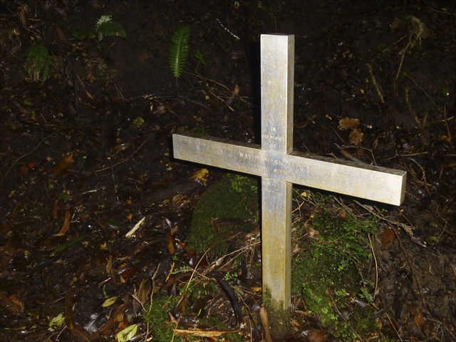
A year later, on 24th July 1953, deerstalkers hunting on Mt Kaiparoro (7 km north-west of Mt Bruce) came across the wreckage of NZ2124 on a forest-covered ridge south-east of the summit. Next day the deerstalkers led a party, comprising members of the police, RNZAF officers, and members of the Masterton Tramping Club, to the crash site. The remains of the pilot were buried at the site following a burial service led by Wing Commander J R S Agar, and the grave is marked by a white cross suitably engraved with the pilot’s name.
The Court of Enquiry concluded that the pilot headed north from Masterton but it seemed he then turned back, possibly due to bad weather conditions, and found himself in the Makakahi Valley heading towards the ranges. From the reading of the direction indicator of the crashed aircraft and the lie of the wreckage, it appeared to investigators that the pilot attempted to fly out of the valley by making a turn to starboard, but hit the ridge on which the wreckage was found while in a steep turn.
Last month, almost exactly fifty years after the crash, I led a group of twelve “Thursday Trampers” to a south-pointing ridge on Kaiparoro in search of the crash site. I became interested in finding it after reading the story in a book entitled “Missing! Aircraft missing in New Zealand 1928-2000”, and I chose a ridge which seemed to fit the description given in the book. However, we failed to find it. A week later a smaller group comprising Neville Gray, Gordon Clark and myself tried again. In the meantime we had located two versions of the Tararua ParkMap which showed the location in two different places on another ridge much further to the west. Armed with a GPS with the two spots loaded in as waypoints we searched again, but neither place turned up any sign of wreckage. Finally, we scrambled down a third ridge, situated between the two already searched, and this time – success!
The largest pieces of wreckage were the two radial engines, the rest being mostly small pieces of twisted metal spread over 100 metres or more down a steep slope. After 50 years the cross marking the grave is still in good condition.
Please respect the site and leave everything as you find it – souveniring is frowned upon!