Blue Basin Loop Geology EarthCache
-
Difficulty:
-

-
Terrain:
-

Size:  (not chosen)
Please note Use of geocaching.com services is subject to the terms and conditions
in our disclaimer.
Located just off the John Day highway, Blue Basin is a badlands-style outcrop area where bluish-gray sediments of the lower John Day Formation are exposed. The Blue Basin, named for the aquamarine color of the fragile tuff beds, is a deeply eroded badland circumnavigated and invaded by a developed trail. The bluish tuffs are 29.8 million years old (Oligocene). These tuffs were deposited as ash erupted from volcanoes to the west, and possibly added to by the Tower Mountain volcano to the east.
One of the most prominent layers in the eroded basin was derived from Mt. Mazama (present day Crater Lake) when it violently erupted 7700 years ago and deposited copious amounts of ash throughout western North America. Prevailing winds blew the ash towards the basin, and fallout deposited them in distinct layers. The ash settled into shallow lakes, wetlands and forests – as did the remains of many large animals, including turtles and rodents.
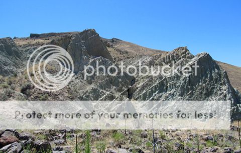 Tuff layers in Blue Basin, tilted amidst fluvial erosion activity
In this basin, pioneer paleontologists Edward Cope and John Marsh collected fossils competitively in the 1870's. The fossils recovered here more recently including specimens of turtles, opossums, dogs, bear-dogs, bears, horses, rhinoceros, giant pigs, oreodonts, and mountain beavers, as well as a variety of rodents. Current day paleontologists aim towards preserving the landscape by doing in-situ examinations of fossil specimens, so that they can study the paleoecology of the area in tandem with the animals.
The loop trail around the Blue Basin is easiest if hiked clockwise. I have denoted 5 waypoints where points of interest/questions to answer are located. Begin along the trail to the left that skirts the grassy backslope of the basin. The trail leads to sculpted cliffs on the east side of the basin, and after a mile climbs for a prolonged overview as it navigates the top of the basin. The gravel trail finally descends steeply to the interior of the Blue Basin. Several large fossil specimens, including a turtle and an oreodont, are preserved in place and information placards provided along the trail. Interpretive signs explain the rocks and the processes of fossilization.
What I want you to take away from this earthcache location is a sense of how a present badlands environment provides a glimpse into an ancient environment that was drastically different than what you see today. The loop hike gets the blood flowing, and the interpretive signs and viewpoints allow you to take a break and marvel at not only the splendor of the landscape, but also how empirical investigation into the many facets of geoscience provide a comprehensive story of the Blue Basin. I highly recommend stopping down the road at the nearby Fossil Beds visitor center, and partaking in the Sheep Rock Unit earthcache GC16XFY
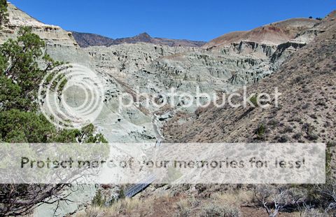 Trail to the amphitheater-like center of the basin badlands
USGS describes the geology of the Blue Basin as primarily composed of mudstone, with mixed volcanic rocks desribed as “Vent-filling ash-flow tuff is intruded by dacite and rhyolite plugs and dikes and ringed by a belt of rhyolite domes and flows. The caldera margin is coincident with prominent gravity and aeromagnetic anomalies. The volcanic field contains 18 map units that range in composition from basalt to rhyolite.” - Walker, G.W. and MacLeod, N.S., 1991, Geologic map of Oregon: U.S. Geological Survey. The John Day Formation is surrounded by the larger, encompassing Picture Gorge Basalt, a unit of the parental Columbia River Basalt Group.
Important Geological Terms
Ash Deposits – Unconsolidated, fine-grained material ejected from the crater of a volcano during eruptions. Essentially bits of pulverized rock and glass less than 2 millimeters (0.1 in) in diameter. They fallout of the atmosphere and into distinct layers.
Claystone/Mudstone - A sedimentary rock composed mostly of clay-sized (0.004mm) sediment particles, and is massive, meaning its structure cannot be split into even layers. Mudstones are differentiated from Claystones in that they slake (swell and disintegrate) when wetted and a weak force is applied.
Badlands - Any landscape characterized by deep dissection, ravines, gullies, and sharp-edged ridges which have been created by fluvial erosion acting on rocks of low resistance, occurring in a semi-arid environment.
Basin - A large, sediment-filled depression, enclosed by higher land, with or without a hydrologic outlet. The Blue Basin's formation is particular to tectonic flexure.
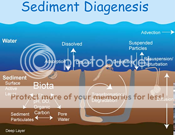
Diagenesis - Post-depositional processes of compaction and cementation of sediments when they are at or near the surface, occurring at relatively low temperatures and pressures; thus not Metamorphic in origin.
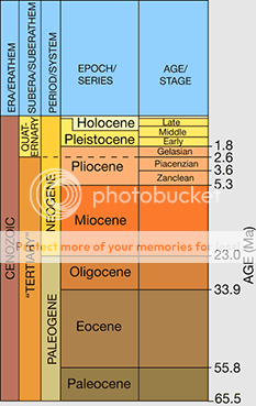
Eocene - The middle epoch of the Paleogene period. It extends from 55.8 - 33.9 million years before present. At this time, mammals were abundant, and modern carnivores became well established.
Evolution - The gradual process by which living organisms change from more primitive forms and slowly evolve into species different from a common ancestor. The major driving force of evolution is the change in gene frequency amongst a population over time.
Fossils - The remains of the whole or part of any dead organism, plant or animal, preserved by natural causes in crustal rocks. Chemical alteration or replacement is common, but some fossil remains may be found only as molds or impressions in surrounding rocks.
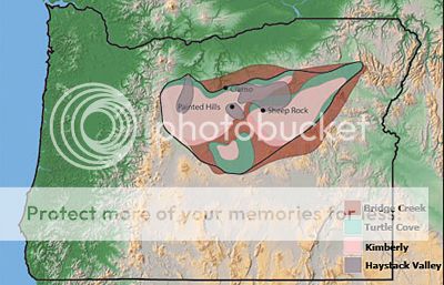
John Day Formation - A series of rock strata layers amongst the Picture Gorge Basalt of the John Day River basin. The extensive strata is typically divided into four units, all fossiliferous: Bridge Creek Flora (shales, paleosols), Turtle Cove (ash deposits, tuff), Kimberly Assemblage (volcaniclastics) and Haystack Valley (tuff, claystone).
 Mt. Mazama - An ancient volcano that was located in southern Oregon. Roughly 7700 years ago, volcanic activity throughout the Mazama structure and edifice culminated in a cataclysmic VEI 7 eruption. Several cubic miles of pumice and ash were spread throughout the Pacific Northwest, resulting in a chronostratigraphic layer called the 'Mazama Ash'.
Oligocene - The final epoch of the Paleogene period. It extends from 33.9 - 23.0 million years before present. Temperatures during this epoch cooled compared to the Eocene, as Earth was heading towards a series of Ice Ages in the Neogene period.
Paleontology - The scientific study of fossil remains, including trace fossils. The study provides evidence that strengthens stratigraphical relationships among sedimentary rock layers/units.
Paleosol - An ancient soil horizon or buried fossil soil in which organic remains provide possibilities of dating or reconstructing paleoenvironmental conditions. There are many widely utilized techniques, including radiocarbon dating & pollen analysis.
Permineralization - The process where fossil remains are impregnated by minerals, such as calcite, iron, or silica, from nearby water sources. The minerals replace dissolved organic material such as fiber, tissue, cellulose, and lignin.
Picture Gorge Basalt - A subgroup of basaltic formations derived from the Columbia River Flood Basalts that erupted throughout the Miocene (17 – 6 million years ago), covering large portions of Crook, Wheeler, and Grant counties.
Tuff – A variably-colored, gritty-textured volcanic rock composed of small lumps of pumice and bits of angular rock fragments embedded in a matrix of consolidated volcanic ash. The ash, pumice, and rock fragments are produced during highly explosive, gaseous eruptions.
Logging the Earthcache:
In order to claim this earth-cache, please email Vadrosaul (via the profile link at the top of the page) with answers to 4 of the 7 following questions. Use the 5 waypoints provided to answer most questions. Although it is optional, pictures of you, your group at the earthcache site, and the surrounding landscape would be appreciated:
1. Record your elevation at the parking lot, then record your elevation at what you think is the highest point along the trail. Determine the difference between the two as your change in elevation.
2. Would the Mazama ash layer be thicker or thinner in Pendleton, Or? What about Medford, Or?
3. Besides fossils, what feature changes the colors of the rocks seen in the Blue Basin?
4. What process, in concert with Permineralization, fossilizes plant and woody material?
5. Roughly how many species of plants & animals have been identified in the John Day Fossil Beds?
6. What group of organisms tend to disturb animal remains before they can be fossilized?
7. What cat-like species disappeared from the North American fossil record 24 million years ago?
References
John B. Whittow - Dictionary of Physical Geography
Ellen Morris Bishop - Hiking Oregon's Geology
E. William Anderson, Michael M. Borman, and William C. Krueger - OSU: John Day Ecological Province
Oregon Paleo Lands Institute - Geologic Formations of the John Day Basin
USGS Mineral Resources Online Spatial Data - Oregon Geologic map data
National Park Service - John Day Fossil Beds National Monument
University of California Museum of Paleontology - Fossils: Window to the past
Additional Hints
(No hints available.)