The Isle of Man is a beautiful and fascinating place to visit, but did you know that it was not always where it is today? About 480 million years ago, much of the Isle of Man lay 60° south of the equator and has since moved northwards to where it is today.
Of course it didn’t always look the same either, it’s actually made up of parts of different continents which existed millions of years ago. It has seen different types of climate along the way and also has glacial deposits which formed the north part of the island during the last (or current!) Ice Age about 70,000 to 10,000 years ago.
The Earth’s crust is made up of several distinct “plates” which are constantly moving, sometimes gradually but sometimes causing earthquakes and tsunamis. Sometimes, part of one plate may separate and join another. The continents and oceans we know today are the results of that process so far.

Two of the largest land masses millions of years ago were Laurentia, which sat mainly north of the equator and Gondwana, which was near the South Pole. These were separated by the Iapetus ocean.
North America, Greenland and northern Britain, including Scotland, originated in the continent of Laurentia.
Land which now forms Africa, South America, India, Antarctica and parts of Europe originated in Gondwana. Much of the Isle of Man and the rest of southern Britain formed part of a small landmass called Avalonia situated along the northern edge of Gondwana.

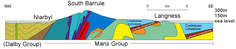 Above is a west-east cross section of the island at Niarbyl. Usually younger rocks lie on top of older rocks but the various faults, such as the one at Niarbyl, cause rocks of different ages to appear next to each other.
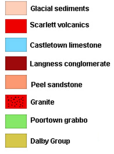
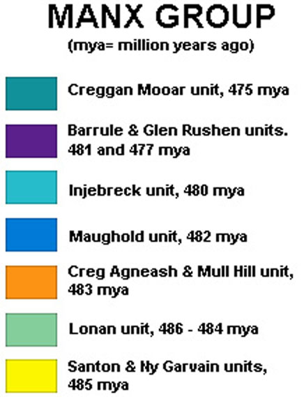
The rocks which form the largest part of the island are known as the Manx Group, many of these were originally formed by sediments deposited on the sea bed and are around 470 to 480 million years old. However, on its travels over time the island has also collected a smaller amount of rock from Laurentia. These rocks are known as the Dalby group and were formed about 425 million years ago, we know this mainly from the evidence of fossil remains found in the rocks. The contact between the two groups is evident as a major geological fault which can clearly be seen on the coast at Niarbyl. It is the only visible remnant of the Iapetus ocean.
Indeed, if you walk down the hill from the car park at the cafe, then 10 metres north from the cottage at Niarbyl beach you can stand with each foot on different rocks derived from two separate continents. Anecdotally it is said you are then standing with one foot in Africa and one in North America!


To claim a 'find' for this Earthcache you must answer the following questions and send your answers in a message to the owner using the link at the top of the page. You can log your find as soon as you have sent your answers to the tasks. We will be in contact if there is a problem. We would also love to see any photographs of you standing on two continents at once!
1. The fault line between the two types of rock is at approximately a 45° angle. Is the Manx group or Dalby group of rocks below the fault line at sea level?
2. One of the types of rock shows clear evidence of bedding, or layering. Which side of the fault line, north or south, is this rock?
3. If you are standing where you can see the fault line you should also be able to see a small cave. In which type of rock is it and approximately how old is that rock?