This Earthcache is located in Ramp Road Park in Cocoa Beach. Thank you to Cocoa Parks and Recreation for permission. There is no physical container to find. To get your smiley for the cache e-mail your answers for the questions below to the cache owner.
What is an Island?
An island is a body of land surrounded by water. There are two main type of islands; continental islands and oceanic islands.
Continental Islands Definition:
Continental islands are part of a continental shelf. One way continental islands form is through the weathering and erosion of a link of land that was once connected to an island of the mainland over time. Another way continental islands are formed is due to changes in sea level. An example of a continental island is Great Britain as it sits on the continental shelf of Europe.
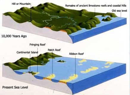
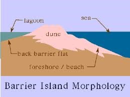
Barrier islands are a specific type of continental island separated from shore by a lagoon or sound. They are called barrier islands due to the fact that they act as barriers between the ocean and the mainland. They are often formed when ocean currents pile up sediment (sand, silt, and gravel) on a sandbar parallel to the coastline and the sandbar rises above the water and becomes an island.
Oceanic Islands Definition:
Oceanic islands are islands that are not sitting on a continental shelf. Oceanic islands are often formed when tectonic plates move and volcanoes erupt on the ocean floor. The eruption builds up layers of lava that if eventually break the water’s surface and forms an island. An example of oceanic islands is the Hawaiian and Samoan Islands.
High Island and Low Islands:
Islands are classified as “High” or “Low”. No matter what their height, islands of volcanic origin are known as “high islands.” Continental islands are called “low islands” even if they are taller than high islands.
The Story of Cocoa’s 1,000 Islands
Sometime in the past three thousand years or so, a storm hammered the coast of Brevard. Winds broke up the vegetation, and waves pounded the beach. Along the beach dune there was a weakened section in the protective vegetation. Waves sliced at this weakened section until water plowed through, uprooting palmettos at first. The violent waves caused the entire island to be divided in two land masses.
The sea poured through the opening into the lagoon, pushing sand into a delta. The natural movement of beach sand closed the inlet again but the delta remained. Plants particularly mangroves slowly colonized the delta. An interesting fact about mangrove roots is that they slow erosion by providing an oyster habitat which in turn slows the water flow. This slower flow of water enhances sediment deposition in areas where it is already occurring. Over time with minimal flow and sediment deposition occurring along rows of mangroves narrow-elongated canals and small islands began to form into what is known today as 1,000 islands.

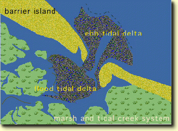
Types of Deltas:
A delta is a triangular deposit of sediment that forms when a water source empties its water into another body of water, such as an ocean, lake, or another river. Two classifications of deltas formed by wave action and tidal influence on sediment moving through inlets are Flood Tidal-Deltas and Ebb Tidal Deltas.
*Flood tidal-deltas: The bulge of sand formed at the interior (land side) mouth of tidal inlets as a result of flow expansion.
*Ebb tidal-deltas: The bulge of sand formed at the exterior (ocean side) mouth of tidal inlets as a result of interaction between tidal currents and waves.
To get credit for the cache please answer the questions below. When answering the questions do your best. It is more important that you learn a new concept about our earth and can apply your knowledge, rather than have a precise answer.
1-What type of island would you classify 1,000 islands as?
2-From the description above would you classify 1,000 islands as a high or low island?
3-Are 1,000 islands an example of a flood tidal-delta or ebb tidal-delta? Why?
4-Which direction is the water flowing? On a scale of 1 to 5 classify the speed of flow with 1 being slow and 5 being fast.
5-Looking at the amount of water flow and vegetation in this particular area what do you think the chances are of significant island erosion over time? Explain your reasoning.
Thank you for visiting this earthcache. Please send your answers to the above questions to the cache owner. In your "found it" log feel free to write about your experience, but don't include the earthcache answers. Thanks and we hope you enjoy the beautiful 1000 islands!
Sources:
http://education.nationalgeographic.com/education/encyclopedia/island/?ar_a=1
http://education.nationalgeographic.com/education/encyclopedia/delta/?ar_a=1
http://en.wikipedia.org/wiki/Thousand_Islands_(Cocoa_Beach)
http://en.wikipedia.org/wiki/Mangrove
http://www.ducksters.com/geography/islands.php