Haralanharju, Kangasala EarthCache
-
Difficulty:
-

-
Terrain:
-

Size:  (not chosen)
Please note Use of geocaching.com services is subject to the terms and conditions
in our disclaimer.
(FIN) Earthcache joka esittelee Haralanharjun Kangasalla.
(ENG) Earthcache that introduces Haralanharju at Kangasala.
 tämä on Earthcache joten et löydä paikalta kätkölaatikkoa tai logikirjaa tähän kätköön liittyen. Tällä Eartcachella käynti osoitetaan suorittamalla kätkökuvauksessa kerrotut tehtävät. Eartcacheen eli maakätköön kuuluu oleellisena osana kohteen geologiaan liittyvä opetuksellisuus.
 This is an Earthcache so you won't find any items, box, physical cache or logbook at this site. you can log you visit by doing given tasks. Each EarthCache provides educational notes about current place geology.
 Haralanharju; GC42TY4

"Mä oksalla ylimmällä
oon harjulan seljänteen.
Niin kauas kuin silmään siintää
nään järviä lahtineen."
"Ah, kuink' on sun maasi kaunis,
kuink ihana taivahas!
Sä järveimme säihkyellä
suo lempemme tulta vaan!"
(Z. Topelius: Kesäpäivä Kangasalla)
Drumlinit ja Haralanharju
(skip to English section.)
Drumlinin muodostuminen ja Haralanharju
Haralanharjulta avautuvat järvimaisemat ovat saaneet voimakkaan maakunnallisen ja kansallisen symboliarvon Topeliuksen sanoittaman Kesäpäivä Kangasalla laulun myötä.
Ensimmäinen näkötorni rakennettiin Haralanharjulle 1890-luvulla. Se tuhoutui tulipalossa vuonna 1922. Uusi torni valmistui vuoden 1932 juhannukseksi. Suinulan Nuorisoseura rakensi tornin talkoilla kyläläisten luovuttamista hirsistä. Torni remontoitiin vuonna 2003. Peruskorjaukseen käytettiin kymmeniä tuhansia euroja. Koko remonttiin käytetty työ paloi savuna ilmaan 10.1.2007, kun tornin yli 70 vuotta kestänyt historia päättyi tuhopolttoon. Tornin poltti sama mies, joka poltti myös Keisarinharjun näkötornin vuotta aiemmin. Kolmannen tornin avajaisia vietettiin kesällä 2009.
Vaikka Haralanvuoren toinen nimi on Haralanharju, se ei geologisesti ole harju vaan Drumlini eli moreenimäki. Drumliinit ovat Suomen merkittävin moreenimuodostumatyyppi, kun otetaan huomioon muodostumien lukumäärä, levinneisyys ja koko. Ne ovat syntyneet drumlinisaatiossa, joka on virtaviivaistanut jäätikön pohjan esteet (kalliokohoumat ja lujat, ei-muokkaantuvat (ei-deformoituvat) maaperän kerrostumat) jään virtauksen helpottamiseksi. Drumlinisaatiossa jäätikön alustan maaperän kerrostumat muokkaantuvat (deformoituvat), kuluvat ja uudelleenkerrostuvat. Viime aikaisten Etelämantereella suoritettujen seurantatutkimusten mukaan yksittäinen noin 10 metriä korkea drumliini on syntynyt jäätikön pohjalle kymmenen vuoden kuluessa. On kuitenkin mahdollista, että voimakkaan virtauksen alueella drumlinisaatiossa yksittäinen drumliini muuttaa muotoaan, kokoaan tai saattaa hävitä kokonaan. Drumliinien muodon perusteella voidaan tehdä päätelmiä jäätikön virtauksesta niiden synnyn aikana. Pitkät ja suhteellisen kapeat selänteet ovat syntyneet pitkäaikaisen liikkeen vallitessa, deformaation pystyessä muokkaamaan voimakkaasti jäätikön alustaa. Drumliinien syntymisen jälkeen tapahtuneet muutokset jäätikön virtaussuunnissa näkyvät drumliinien muodossa. Uusi liikesuunta muodostaa drumliinien pinnalle erillisiä uuden suunnan mukaisia pieniä drumliineja tai drumliini saa koukkumaisen muodon. Usein drumliinikentät alkavat 10–30 kilometriä isojen reunamuodostumien sisäpuolelta ja jatkuvat jopa 100–200 kilometriä, kuten Pieksämäen tai Kuusamon drumliinikentät. Drumliinien välisiin laaksoihin tai jopa niiden päälle syntyneet harjut ja muut jäätikön sulamisvesien kerrostumat osoittavat drumliinien synnyn päättyneen ennen jäätikön reunaosan perääntymistä niiden alueelle. Drumliinien koko vaihtelee suuresti. Niiden pituus voi vaihdella 100 metristä jopa seitsemään kilometriin ja leveys 50 metristä jopa neljään kilometriin. Drumliinien leveyden ja pituuden suhde on enimmäkseen 1:3–1:8, mutta voi vaihdella välillä 1:2–1:50. Drumliinien korkeus vaihtelee metristä 120 metriin.
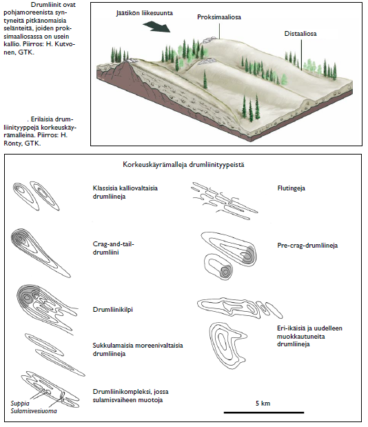
Drumliineissa on usein kallioydin, joka tulee moreenipeitteen alta esiin drumliinin proksimaaliosassa, eli jäätikön tulosuunnan puoleisessa päässä. Drumliinien sisäosassa voi olla vanhempia maaperän kerrostumia, kuten aiempien jäätiköitymisten harjuselänteitä. Drumliinien aineksesta on yleensä pääosa erilaista moreeniainesta, joista yleisin on pohjamoreeni.
Sianselkämäisten, ns. klassisten drumliinien lisäksi tunnetaan useita vaihettumistyyppejä. Sukkulamaiset drumliinit ovat pitkiä ja kapeita selänteitä, joista ei tunneta kallioydintä. Kalliodrumliineissa moreenipeite verhoaa kalliopintaa vain ohuena (0–5 metrin) kerroksena. Drumliinikilvet ovat leveitä usean drumliinin ryhmiä kalliokohouman lakiosassa ja kohouman jäätikön liikkeeseen nähden suojasivulla. Crag-and-tail-termiä on kirjallisuudessa käytetty drumliineista, jotka koostuvat kalliomäestä ja suhteellisesti matalammasta ja kapeammasta ”hännästä” kalliomäen suojasivulla. Fluting-tyypin moreeniselänteet ovat pieniä, 20–200 metriä pitkiä, 1–5 metriä korkeita selänteitä kalliomäkien distaaliosissa tai suurempien drumliinien päällä. Vakoutumisessa syntyneet fluting-selänteet on otettu inventoinnissa huomioon yleensä vain osana laajempia drumliiniryhmiä. Vastasivun (pre-crag) drumliinit ovat kalliomäkien proksimaalisivuille syntyneitä drumliineja, joiden kerrospaksuus on usein 30–50 metriä. Niiden aines sisältää usein normaalia runsaammin savesainesta. Vastasivun drumliinien oletetaan syntyneen viimeisimmän jäätiköitymisen varhaisvaiheessa. Tähän viittaavat niiden suuntautuminen ja aineksen usein normaalia suurempi savespitoisuus, jonka arvellaan olevan osin peräisin viime jääkautta vanhempien savikoiden aineksesta. Suomessa laajin drumliinikenttä on Pieksämäen kenttä, joka noin 12 000 km2 laajuisena kattaa suuren osan Etelä-Savon maakunnasta. Myös Keiteleen, Sotkamon–Kuhmon, Kuusamon ja Utsjoen kentät ovat mittavia. Kemin–Tornion ja Ranuan drumliinikentät ovat syntyneen viimeistä jäätiköitymistä edeltäneen jäätiköitymisvaiheen deglasiaation yhteydessä. Jäänjakaja-alueella, keskisessä Lapissa hyvin kehittyneitä drumliineja tavataan vähemmän.
Jotta voit merkitä logatuksi tämän kätkön sinun
täytyy suorittaa seuraavat tehtävät annetuissa koordinaateissa:
1 )
Perustuen siihen mitä havaintoja teet paikalla arvioi jäätikön etenemissuunta Drumlinin muodostumisen aikana.
arvioi myös tämän Drumlinin korkeus.
2 )
Minkä tyyppinen Drumlini on kyseessä?
millainen ydin sillä on? mistä tiedät tämän?
3 )
Lähetä vastauksesi kätkön omistajalle vaikkapa tällä viestilinkillä.
Kirjoita viestin otsikoksi Haralanharju, Kangasala
(ps. jos valitset viestin alta "I want to send my email address along with this message" vastaamiseni helpottuu)
4 )
Sinun ei tarvitse odottaa loggauslupaa, mutta asiattomat logit tullaan poistamaan. Omistaja vastaa jollain aikavälillä viestiin, jos vastauksissa on epäselvää.
5 )
Toivottavaa on myös että otat valokuvan itsestäsi ja/tai gps laitteestasi Haralanharjulla ja liität se logiisi.
Haralanharju and Drumlins
Haralanvuori, or Haralanharju, located in Suinula, northern Kangasala, is a rocky hill despite its second name. Haralanharju has its own role in the development of Finnish national romanticism.
Kangasala is a municipality in Finland, next to Tampere. Kangasala is famous for its natural beauty and many ridges. Zacharias Topelius (1818–1898) visited lieutenant-colonel Aminoff's farm near Haralanvuori (1853) with his acquaintance, Lotta Lindqvist. Topelius became fond with the views from the "Harjula's ridge" and wrote the famous poem "A Summer's Day in Kangasala" . Later Gabriel Linsén composed a melody for the poem. From 1995 that melody has been the provincial hymn of Pirkanmaa region. The song is one of the most widely known Finnish songs.
Zacharias Topelius (1818 – 1898) was a Finland-Swedish journalist, historian and author and later a rector of the Helsinki University. He wrote Finnish historical novels in Swedish. His writings, plays, poems and historical novels became national property. At Haralanharju, there was a sightseeing tower during years 1932-2007. This tower was burned down by a local pyromaniac at January 2007. So now there were only ashes on this hill where the over 70 year old wooden sightseeing tower used to stand. Suinulan Nuorisoseura ry, a local people's association, buildt yet another new tower witch was opened at 2009.
Building work for the current tower began 2008 and early summer 2009 saw the opening ceremony. The tower is open all year round.
altough "Haralanharju" is in english Esker of Harala, it is not geoligally an esker. It is really a Drumlin.
Drumlins and drumlin clusters are glacial landforms, composed primarily of glacial till, which have been extensively studied. Geologists have proposed several theories about their origin. They are formed a short distance within the receding glacier ice and record the final direction of ice movement. Drumlins occur in symmetric, spindle, parabolic, and transverse asymmetrical forms. Drumlins are commonly found with other major glacially-formed features and are related on a regional scale to these landforms. The large-scale patterns of these features exhibit spatial organization of the drumlin-forming flows with related tunnel valleys, eskers, scours, and exposed bedrock erosion (scalloping and sichelwannen).
Although one formation theory originally proposed since the 1980s by Bohan-Henry and collaborators suggests that drumlin creation by a catastrophic flooding release of highly pressurized water flowing underneath the glacial ice, the recent retreat of a marginal outlet glacier of Hofsjökull in Iceland provided the opportunity for direct study of a drumlin field with formation of >50 drumlins ranging from 90–320 m (300–1,050 ft) in length, 30–105 m (98–344 ft) in width, and 5–10 m (16–33 ft) in height. This, when combined with drumlin formation identified through imaging beneath the West Antarctica ice, resulted in a significant step in geomorphologic understanding. The Hofsjökull marginal drumlins formed through a progression of subglacial depositional and erosional processes with each horizontal till bed within the drumlin created by an individual surge of the glacier. Erosion under the glacier in the immediate vicinity of the drumlin can be on the order of a meter's depth of sediment per year, with the eroded sediment forming a drumlin as it is repositioned and deposited.
Geomorphology
A drumlin's long axis is parallel with the movement of the ice; it is roughly symmetrical around the long axis. Drumlins are typically 1–2 km (0.62–1.2 mi) long, less than 50 m (160 ft) high and between 300 to 600 metres (980–2,000 ft) wide. Drumlins generally have a consistent ratio of 2:3.5 width to length dimensions. Drumlins are often in drumlin fields of similarly shaped, sized and oriented hills. Drumlins usually have layers indicating that the material was repeatedly added to a core, which may be of rock or glacial till. The composition of drumlins varies depending on the area in which they are found, and can consist of similar material to the till of the surrounding moraine or be composed almost entirely of bedrock, sand and gravel or various mixtures thereof.
Many Pleistocene drumlin fields are observed to occur in a fan-like distribution.The Múlajökull drumlins are also arrayed in a splayed fan distribution around an arc of 180°.
Soil development on drumlins
Drumlin soil is variable but on recently-formed drumlins often consists of a thin A soil horizon (often referred to as "'topsoil'" which accumulated after formation) and a thin Bw horizon (commonly referred to as "'subsoil'"). The C horizon, which shows little evidence of being affected by soil forming processes (weathering), is close to the surface, and may be at the surface on an eroded drumlin. Below the C horizon the drumlin consists of multiple beds of till deposited by lodgment and bed deformation. On drumlins with longer exposure (e.g. in the Lake Ontario drumlin field in New York State) soil development is more advanced, for example with the formation of clay-enriched Bt horizons.
To log this cache you must do following tasks in given coordinates:
1 )
based on what you see at the site estimate the direction of the glacier movement at this place at the time when drumlin was born.
estimate the hight of the drumlin.
2 )
How is this drumlin formed?
What kind of core it has? How do you know that?
3 )
Send your answers (for example via this message link) to the cache owner.
Title your post “Haralanharju, Kangasala”
(ps. if you enable selection "I want to send my email address along with this message" it is easier for me to reply)
4 )
You don't have to wait for a logging permission, but any incomplete logs will be deleted. Cache owner will reply something for post if there is some faults in answers.
5 )
It is hoped that you take a photo of yourself and / or your GPS device at the top of the Haralanharju and then paste it to you log.
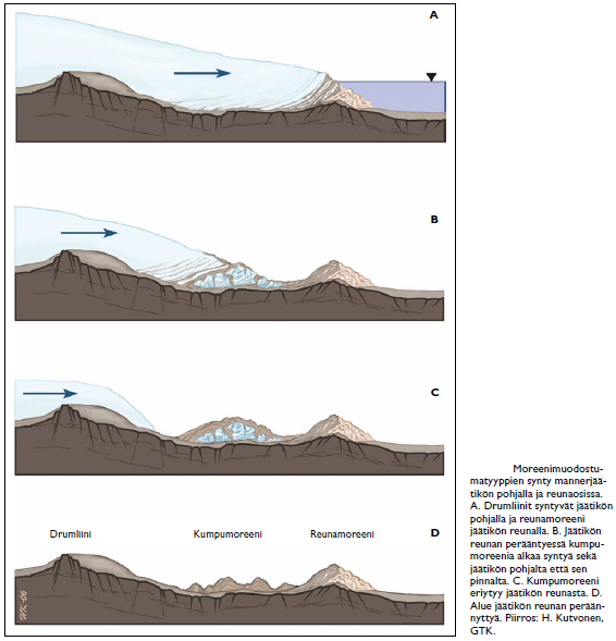
key; Drumliini=Drumlin, Kumpumoreeni=Hummocky moraine, renamoreeni=lateral moraine text: Drumlins and hummocky moraine are born in the bottom of glacier, lateral moraine at the end of glacier.
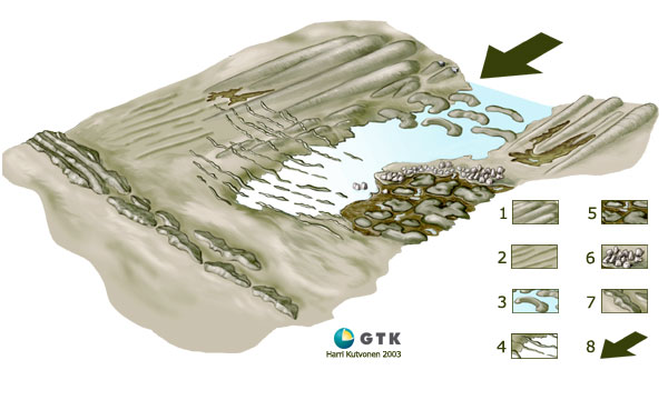
Moreenimuodostumatyyppejä: 1. Drumliineja 2.Vakoumia 3. Rogenmoreeneja 4.De Geer –moreeneja 5. Kumpumoreeneja 6. Lohkareikkoja 7. Reunamoreeneja 8. Jäätikön liikesuunta
Types of Moraines: 1 Drumlins 2. furrows 3 Rogen moraine 4.De Geer moraines 5. Hummocky moraines 6. boulders 7. Lateral moraine 8. direction of Glacial movement<
different types of Drumlins.
Kangasala, Oksalla ylimmällä,
on a branch at the top
In the past the nobility discovered Kangasala in the midst of the country of blue lakes and sunny ridges when they needed a refreshing change in their lives. Kangasala has also offered inspiration for many significant national artists through the years.
Tämä earthcache sarja on omistettu Kangasalan luonnolle
This earthcache series is dedicated to the praise the Beautiful Nature of Kangasala
Kangasalan earthcachet :
 Pallograniitti ja verikivi, Kangasala, GC3R3NK
Haralanharju, Kangasala, GC42TY4
- Maitomies -
you can also contact cache owner via facebook:

Additional Hints
(No hints available.)