
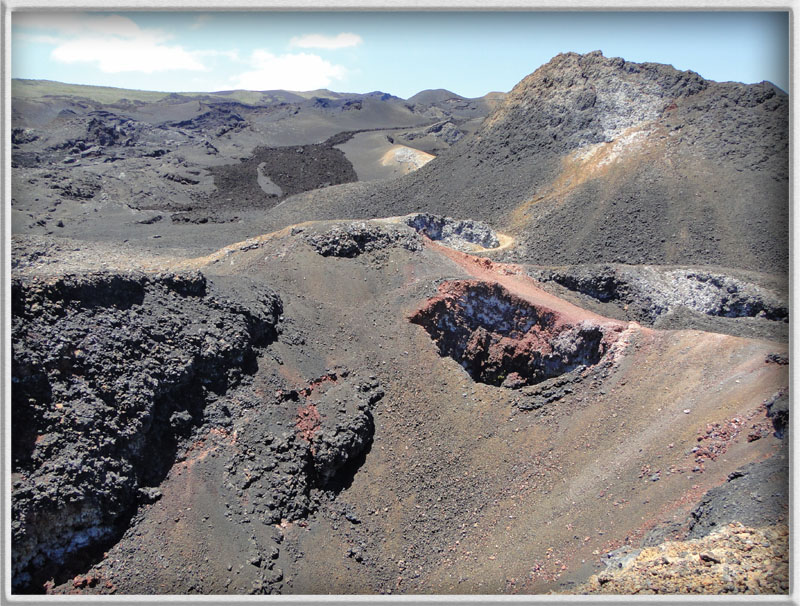
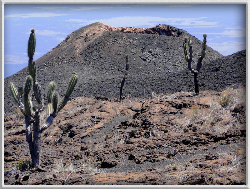
Die Galápagos-Inseln sind geologisch sehr jung und haben ihren vulkanischen Ursprung in einem Hotspot. Aufgrund der Kontinentaldrift sind die westlichen Inseln die jüngsten und zugleich aktivsten des Archipels, wozu die Insel Isabela mit ihren 6 Schildvulkanen gehört. Deren Name begründet sich in ihrem sehr flachen (schildartigen) Aufbau, resultierend aus der sehr dünnflüssigen und schnellfließenden Lava.
Besonders flach und mit der größten Caldera (7,2x9,3 km) aller Galápagos-Vulkane präsentiert sich der Sierra Negra. Sein Alter wird auf ca. eine halbe Million Jahre geschätzt und er ist bis heute sehr aktiv. Allein im 20. Jahrhundert wurden 7 Ausbrüche aufgezeichnet und der vorläufig letzte fand im Oktober des Jahres 2005 statt. Diese anspruchsvolle Wanderung führt euch an die Ostflanke des Vulkans mit einem grandiosen Ausblick in die Caldera und danach bis in den Bereich der aktiven Zone im Nordosten. Dort fanden die jüngsten Eruptionen statt und ihr geht über Pahoehoe-Lava des entsprechenden Alters.
Als Logbedingung müsst ihr die oben genannten Koordinaten erreichen. Dazu dürft ihr in keinem Fall die vorgegebenen und gut ausgeschilderten Wege und Pfade verlassen; ihr befindet euch in einem streng geschützten Nationalpark! Bei Interesse erhaltet ihr hier die zugehörige gpx-Datei. Weiterhin müsst ihr mir bitte die Antworten zu den folgenden drei Aufgaben zusenden (cache(at)lok-lauf.de):
1) Beschreibt bitte, wie sich die Lavaströme der jüngsten Ausbrüche an der Nordost-Flanke je nach Alter in Farbton und Vegetation unterscheiden?
2) An dem Wegpunkt IP findet ihr eine Informationstafel. Hier wird eine Reservoir im Bereich der Erdkruste und dessen Tiefe erwähnt. Wie heißt diese geologische Erscheinung und wie bzw. in welchen Phasen wirkt sich deren Druckerhöhung aus?
3) Beschreibe kurz das Gestein, auf dem du genau bei den Koordinaten dieses Earthcaches stehst.
4) Optional würde ich mich sehr über ein Foto von euch mit schönem Hintergrund freuen.
Ich wünsche euch eine tolle und eindrucksvolle Wanderung! Viel Spaß!

Las Islas Galápagos son geológicamente muy jóvenes y tienen su origen volcánico en un Hotspot. Debido a la deriva continental, las islas occidentales son las más jóvenes y más activas del archipiélago, incluyendo la Isla Isabela con sus seis volcanes de escudo. Cuyo nombre se basa en su muy baja (como un escudo) estructura, producto de la lava muy fluida y rápido fluido.
Especialmente plana y con la caldera más grande (7,2 x9,3 km) de todos los volcanes de Galápagos se presenta la forma en la Sierra Negra. Su edad se calcula alrededor de medio millón de años y sigue siendo muy activo. Solo en el siglo XX se registraron siete erupciones y la última se realizó en octubre de 2005. Esta exigente caminata os lleva al flanco oriental del volcán, con una magnífica vista de la Caldera y luego hasta el sector de la zona activa en el noreste. Las recientes erupciones tuvieron lugar allí y paseáis sobre la lava de Pahoehoe de la edad correspondiente.
Como condición del log es necesario llegar a las coordenadas anteriormente. No se permite salir bajo ninguna circunstancia de los senderos y caminos bien señalizados; ¡os encontráis en un Parque Nacional estrictamente protegido! Si estáis interesados podéis conseguir aquí el archivo gpx adjunto. Además, enviadme por favor las respuestas a las siguientes tres tareas (cache(at)lok-lauf.de):
1) Describid cómo se distinguen los flujos de lava de las erupciones recientes del flanco noreste, dependiendo de la edad, en tonalidad y vegetación?
2) En el punto IP encontráis un panel de información. Aquí se menciona un depósito en la corteza de la Tierra y su profundidad. ¿Cómo se llama este fenómeno geológico, y cómo y en qué fases inciden los efectos del aumento de la presión?
3) Describid brevemente la roca sobre la cual estáis exactamente en las coordenadas de este Earthcache.
4) Opcionalmente, yo estaría encantado de tener una foto de vosotros delante de un buen fondo.
Os deseo una gran y impresionante caminata! Que os divirtáis!

The Galapagos Islands are geologically very young and have their volcanic origin in a hot spot. As a result of the continental drift, the western islands are the youngest and at the same time the most active of the archipel ago, to which Isabela island with its six shield volcanos belongs to. Their names originate from their very flat (shield-shaped) structure because of the highly fluid and fast flowing lava.
Sierra Negra is especially flat and has the largest caldera (7.2x9.3km) of all Galapagos volcanos. It is estimated to be half a million years of age and remains very active up until today. In the 20th century alone seven eruptions have been recorded and the latest has occurred in October 2005. This challenging hike leads you to the eastern flanks of the volcano with a magnificent view inside the caldera and afterwards towards the active zone in the northeast. There, the latest eruptions have taken place and you walk on the pahoehoe lava of respective age.
As log-in condition you will have to get the above-mentioned coordinates. Please remember that you must not leave the specified and well sign-posted paths as you are in a strictly protected National Park! If interested, you will get the corresponding gpx-file here. Furthermore, please email the answers to the following three questions (cache(at)lok-lauf.de):
1) Please describe the differences in colour and vegetation of the lava streams of the latest eruptions at the northeast flank depending on their age.
2) You will find an information board on the waypoint IP, on which a reservoir in the area of the earth crust and its depth is mentioned. How do you call the geological phenomenon and how or rather in which phases does the increase in pressure have an impact?
3) Please explain briefly the rock, on which you stand using the exact coordinates of this Earth Cache.
4) Optionally, I would be very happy to receive a photo of you with a nice background.
I wish you a fantastic and impressive hike. Have fun!