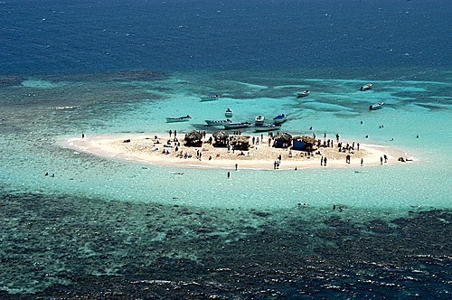

An der Nordküste der Dominikanischen Republik, nahe der Grenze zu Haiti befindet sich im Nationalpark Monte Cristi ein vorgelagertes Barriereriff mit einem sehenswerten Mikro-Atoll namens Cayo Arena.
Nahezu majestätisch erhebt sich der kleine Sandberg aus dem Wasser und versetzt jeden Besucher in bloßes Staunen. Die ca. 60 x 25 m große Fläche mit puderweißem Sand, lässt das umliegende Wasser in den schönsten Türkis- und Blautönen erscheinen, dass man sich daran gar nicht satt sehen kann. Die einzigartige Natur allerdings befindet sich unter Wasser. Die umliegenden Korallenbänke sind ein Magnet für zahlreiche Fische in den unterschiedlichsten Farben, sodass das Schnorcheln in solch einer spektakulären Kulisse zu einem unvergesslichen Erlebnis wird.
Entstehung der Karibik:
Man glaubt, dass die Karibische Platte eine große Magmatische Großprovinz ist, die vor mehreren Mio. Jahren den Pazifischen Ozean bildete.
Als der Atlantische Ozean sich ausdehnte, wurden Nord- und Südamerika nach Westen geschoben, und der Boden des Pazifischen Ozeans begann unter die westlichen Kanten des amerikanischen Kontinents zu tauchen. Die Karibische Platte ist dicker und liegt höher als der Rest des Bodens des Pazifischen Ozeans. Anstatt sich über den Boden des Atlantischen Ozeans hinwegzusetzen, bewegt sie sich in den Osten nach Nord- und Südamerika. Mit der Bildung des „Isthmus von Panama“ vor ungefähr 3 Mio. Jahren, verlor die Karibische Platte endgültig die Verbindung zum Pazifik. An ihren Grenzen kommt es, auch heute noch, oft zu seismischen Aktivitäten, häufigen Erdbeben, gelegentlichen Tsunamis und vulkanischen Ausbrüchen.
Geologie des Riffs:
Vom Ordovizium bis zum Perm sind die „Tabulata“ ("Bödenkorallen") und die „Rugosa“ („Runzelkorallen“) die ersten Riffbildner unter den Blumentieren. Von da an kann man von Korallenriffen sprechen. Im Silur und im Devon wurden Riffe aber nicht nur von Korallen, sondern auch von Stromatoporen genannten Lebewesen aufgebaut, die eventuell mit den Schwämmen verwandt sind. Mit dem Massenaussterben an der Perm-Trias-Grenze, dem auch die Rugosa und die Tabulata zum Opfer fielen, kam die Riffbildung zunächst zum Erliegen. Ab der Mitteltrias erschienen die ersten Steinkorallen und nahmen im Laufe des Mesozoikums immer mehr zu. Im oberen Mesozoikum werden die zu den Muscheln gehörenden Rudisten zu weiteren wichtigen Riffbildnern. Sie sterben an der Kreide-Tertiär-Grenze aus. Seitdem sind die Steinkorallen die wichtigsten Riffbildner.
Entstehung des Korallenriffs:
Die "Riffbauer" sind die Korallen, die ein lockeres Grundgerüst bauen. Und andere Lebewesen sind für die Statik, Stabilität und Schutz von großer Bedeutung. Wie z.B. Steinkorallen, Schnecken, Algen, Würmer, ...
Korallen pflanzen sich asexuell (Knospung) als auch sexuell (Eizelle und Spermien) fort. Asexuelle Fortpflanzung dient der Ausdehnung eines Polypen und sexuelle Fortpflanzung dient der Verbreitung einzelner Arten. Ein Korallenpolyp misst weniger als 1 cm Durchmesser. Korallenpolypen nehmen nicht nur durch die einzige Öffnung (Mund- und Afteröffnung zugleich) ihre Nahrung zu sich, sondern auch über die Körperoberfläche. Korallenstöcke mit reichlich Kalkbildung bilden kugelige, massive Kolonien und Korallenstöcke mit wenig Kalkbildung bilden dagegen flache, konsolenartige Skelette. Korallenriffe sind ein dynamisches System, welches ständig Veränderung unterworfen ist.
Ein Korallenriff ist eine von hermatypischen (riffbildenden) Nesseltieren gebildete Riffstruktur im Meer, die groß genug wird, um einen bedeutenden physikalischen und ökologischen Einfluss auf ihre Umgebung auszuüben. Es sind die größten von Lebewesen geschaffenen Strukturen der Erde. Die Gesamtfläche der heutigen Korallenriffe liegt bei 600.000 km². Korallenriffe werden im Wesentlichen von Korallen aus der Gruppe der Steinkorallen (Scleractinia) aufgebaut. Steinkorallen besiedeln sowohl die Tiefsee als auch das Flachwasser bis zur Wasseroberfläche. Sie bauen im Laufe vieler Jahrhunderte aus ihren Kalk-Skeletten die Riffstruktur auf.
Eine Koralleninsel entsteht durch langfristige Veränderungen des Wasserstandes. Da das Korallenriff bis zur Wasseroberfläche wachsen kann, bildet sich nach späterem Absenken des Meeresspiegels oder Anheben des Bodens eine Insel oder eine Reihe von Inseln, oft in Form eines Atolls.
Nach ihrer geographischen Verbreitung kann man Korallenriffe in zwei Typen einteilen: die tropischen Korallenriffe und die Tiefwasserriffe.
Tropischen Korallenriffe:
Riffbildende Korallen aus tropischen Korallenriffen können nur bei Wassertemperaturen überleben, die 20 °C nur sehr selten unterschreiten. Aus diesen Gründen beschränkt sich die Entstehung auf einen Bereich ungefähr zwischen 30° nördlicher und 30° südlicher Breite. Im Atlantik liegen die nördlichsten Korallenriffe an der Küste der Bermudas, die südlichsten etwas nördlich von Rio de Janeiro. Zwar finden sich noch zwei Arten normalerweise riffbildender Steinkorallen bei Cape Hatteras an der Ostküste der Vereinigten Staaten, sie bilden dort jedoch keine Riffe mehr.
Tiefwasserriffe:
Viele Steinkorallenarten können auch in kühlerem und kaltem Wasser bei Temperaturen unter 20 °C leben. Aus dem Mittelmeer sind mindestens 37 Steinkorallenarten bekannt, die allerdings keine Riffe bilden. Die Mehrzahl der Steinkorallenarten in kühlem und kaltem Wasser sind solitäre Korallen aus den Familien der Caryophylliidae und Dendrophylliidae, welche sehr langsam wachsen, klein bleiben und daher keine Riffe bilden. Im Unterschied zu ihren tropischen Verwandten nutzen sie nicht das Sonnenlicht als primäre Energiequelle, sondern ernähren sich von Zooplankton.
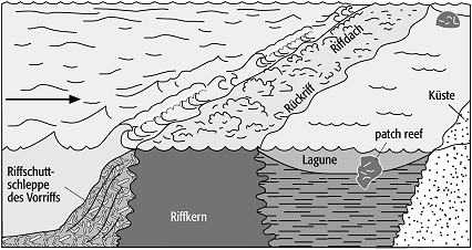
Barriereriff:
Ein Barriereriff, oder auch Wallriff, erstreckt sich parallel zu einer Küste. Im Gegensatz zu einem Saumrif, welches in der Innenseite (Lagune) nur wenigen Meter tief ist, kann hier die Lagunenseite 50-100m tief sein.
Die Breite eines Barriereriffs kann mehrere Kilometer betragen. Durch die wellenbrechende Wirkung des Barriereriffs entsteht eine geschützte Wasserzone in Richtung Küste. Bei der verringerten Wellenenergie sind im Lagunenbereich feinkörnige Kalksande und Kalkschlämme charakteristisch. Kleine, wenig differenzierte Riffstrukturen (Patchreefs) können auftreten. Steile Vorriff-Hänge mit ausgedehnten Riffschuttschleppen sind ausgebildet. Auch auf der lagunenwärtigen Seite kann ein "innerer Riffhang" ausgeprägt sein. Das bekannteste Barriereriff ist in Australien das "Great Barrier Reef"
Sie schützen Küsten von tropischen Stürmen und Tsunamis. Dieser Schutz ist wahrscheinlich wichtiger geworden als der Klimawandel vorhergesagt wird, da tropische Stürme immer häufiger und schwerer werden.
Die sichtbaren Teile der farbenprächtigen Korallenriffe stammen aus der letzten Kaltzeit, die etwa 10.000 Jahre zurückliegt. Von diesem Zeitpunkt an konnten sich die unterschiedlichen Korallenarten wieder auf den verbliebenen Kalksteinen ansiedeln und zum einzigartig vielfältigen Lebensraum unzähliger Tierarten und Pflanzen werden. Auch in der Zukunft wird das Riff sowohl sein Aussehen als auch seine Ausdehnung verändern, da es sich um einen lebenden Organismus handelt, der aufgrund verschiedener Einflüsse einem ständigen Wandel unterliegt.
Entstehung eines Atolls:
Ein Atoll hat einen ring- oder hufeisenförmigen Riffkranz mit einer zentralgelegenen Lagune, die selten tiefer ist als 50m. Der Durchmesser eines Atolls kann bis Zehnerkilometer erreichen. Atolle kommen ausschließlich in tropischen Gewässern, hauptsächlich im Pazifischen Ozean und im Indischen Ozean vor, im Karibischen Meer gibt es nur 4 Atolle. Einen Staat, der nur aus Atollen besteht, bilden die Malediven.
Der Begriff Atoll wird vom maledivischen Wort "atolhu" hergeleitet. Die Entstehung der Atolle ist auf unterseeische Vulkaninseln zurückzuführen, um deren absinkende Gipfel sich ringförmig Korallenriffe ausbildeten, die im Laufe der Zeit bis an den Ozeanspiegel anwuchsen. Es gibt drei Stadien in einer Entwicklungsreihe:
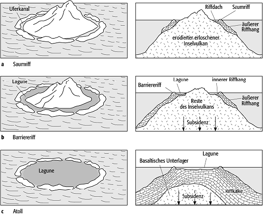
A Junge erloschene Vulkaninseln bilden den Untergrund für die Saumriffe.
B Mit dem Absinken der Inseln durch Subsidenz entsteht zwischen Insel und Riff eine Lagune und damit ein Barrierriff.
C Nach dem endgültigen Absinken entsteht ein Atoll

Abb. : Entstehung eines Atolls, Quelle und © NOAA
In der Lagune des Atolls sammelt sich bioklastisches Sediment an, das sowohl aus Riffschutt als auch aus Kalkskeletten von in der Lagune lebenden Organismen besteht.Riffbauende Korallen benötigen neben ausreichender Helligkeit über 18ºC warmes, klares, sauerstoff- und salzreiches Meereswasser. Daher sind Atolle eine häufige Inselform der tropischen Meere ausserhalb sedimentreicher Flussmündungsgebiete.
Logbedingungen:
Ermittelt die Antworten zu folgenden Fragen
Schickt bitte vor dem Loggen Eure Antworten an meinen GC-Account und loggt direkt online; ich melde mich, falls es Probleme mit den Antworten geben sollte. Logs ohne Antwortmail werden gelöscht.
- 1. Atollgrösse: Ermittle vor Ort den Durchmesser des Aussenriffs (lange Seite)
- 2. Lagunenbreite des Barriereriffs: Ermittle vor Ort den Abstand des vorgelagerten Riffs zur Küstenlinie
- 3. Die Insel ist nur auf den ersten Blick komplett weiss. Welche Farbpartikel kommen bei genauerer Betrachtung noch vor und aus was bestehen sie?
- 4. Ermittle vor Ort die Korngröße des Sandes (visit Link)
- 5. Optional wäre es schön, wenn du deinem Log ein Foto von dir und deinem GPS-Gerät mit einstellen würdest, bei dem man im Hintergrund die Insel sieht.
Bitte bedenkt! Ihr befindet euch im Nationalpark Monte Christi. Es ist VERBOTEN Muscheln, Korallen, Sand oder ähnliches mitzunehmen !!!!

English Version:
On the north coast of the Dominican Republic, near the border with Haiti is located in the Monte Cristi National Park an offshore barrier reef with a spectacular micro-atoll called Cayo Arena.
Almost majestically, the little sand hill rising out of the water, and any visitor to mere amazement. The 60 x 25 m wide area with powder white sand, the surrounding water can appear in the most beautiful turquoise and blue tones, that one can not get enough of it. The unique nature but is underwater. The surrounding coral reefs are a magnet for numerous fish in different colors, so the snorkeling in such a spectacular setting will be an unforgettable experience.
Emergence of the Caribbean:
It is believed that the Caribbean Plate is a large igneous province large that several million years ago formed the Pacific Ocean. As the Atlantic expanded, North and South America were pushed westward, and the floor of the Pacific Ocean began in the western edge of the American continent to dive. The Caribbean Plate is thicker and higher than the rest of the floor of the Pacific Ocean. Rather than ignore the bottom of the Atlantic Ocean, it moves into the East to the Americas. With the formation of the "Isthmus of Panama" about 3 million years ago, the Caribbean Plate finally lost the connection to the Pacific. At its borders, is it still to seismic activity, often frequent earthquakes, occasional tsunamis and volcanic eruptions.
Geology of the reef:
The Ordovician to the Permian are the "Tabulata" and "Rugosa", the first among the flowers Riffbildner animals. From then on, one can speak of coral reefs. In the Silurian and Devonian reefs were constructed but not only corals but also of stromatoporoid said animals that are possibly related to the sponges. With the mass extinction at the Permian-Triassic boundary, which includes the Rugosa and Tabulata fell victim to the Riffbildung initially came to a standstill. From the Middle Triassic appeared the first corals and took over more and more of the Mesozoic. Upper Mesozoic be belonging to the shells rudists other important Riffbildnern. They are dying out at the Cretaceous-Tertiary boundary. Since then, the hard corals are the main Riffbildner.
Formation of the coral reef:
The "reef builders" are the corals that build a loose framework. And other animals are for the statics, stability, and protection of great importance. Such as Stony corals, snails, algae, worms, ...
Corals reproduce asexually (budding) and sexually (egg and sperm cells). Asexual propagation of the expansion of a polyp and sexual reproduction is used for distribution of individual species. A coral polyp measures less than 1 cm in diameter. Coral polyps do not only through the single opening (mouth and anus at the same time) to their food, but also on the body surface. Coral colonies with abundant calcification form spherical, massive colonies and coral heads with little calcification in contrast appear flat, bracket-like skeletons. Coral reefs are a dynamic system that is constantly subject to change.
A coral reef is a (hermatypic) herma typical of cnidarians reef structure formed in the sea, which is large enough to exert a significant influence on their pysikalischen and ecological environment. They are the largest structures created by living creatures of the earth. The total area of coral reefs today is 600,000 km ². Coral reefs are built mainly of coral from the group of stony corals (Scleractinia). Stony corals colonize both the deep and the shallow water to the water surface. They build over many centuries from their lime skeletons on the reef structure.
A coral island is caused by long-term changes in the water level. Since the coral can grow up to the water surface, is formed on the subsequent lowering of sea level or raising the floor an island or series of islands, often in the form of an atoll.
According to their geographical distribution can be divided into two types of coral reefs: tropical coral reefs and the deep water reefs
Tropical coral reefs:
Reef-building corals from tropical coral reefs can only survive in water temperatures below 20 ° C are very rare. For these reasons, limited the development to a range between approximately 30 ° north and 30 ° south latitude. The northernmost coral reefs in the Atlantic Ocean on the coast of Bermuda, the southernmost just north of Rio de Janeiro. Although there are two types normally riffbildender stony corals at Cape Hatteras on the east coast of the United States, they form there is no more reefs.
Deep water reefs:
Many species of stony corals can live in cooler and cold water at temperatures below 20 ° C. From the Mediterranean at least 37 species of stony corals are known, but do not form reefs. The majority of hard coral species in cool and cold water are solitary corals from the families and Caryophylliidae Dendrophylliidae which grow very slowly, remain small and therefore do not form reefs. Unlike their tropical relatives, they do not use the sun as the primary energy source, but also feed on zooplankton.
barrier reef:
A barrier reef or barrier reef extends parallel to a coast. Unlike a Saumrif, which is in the inside (lagoon) only a few feet deep here, the lagoon side of 50-100m deep.
The width of a barrier reef can be several kilometers. By the wave-breaking effect of the barrier reef creates a protected water area to the coast. Are at the reduced wave energy in the lagoon area fine grained Kalksande and lime sludge characteristic. Small, poorly differentiated reef structures (Patchreefs) can occur. Steep slopes with extensive Riffschuttschleppen Vorriff-formed. Also on the page can lagunenwärtigen an "inner reef slope" be pronounced. The most famous barrier reef is in Australia the "Great Barrier Reef"
Coral reefs also protect coastlines from tropical storms and tsunami. This protection is likely to become more important as climate change is predicted to make tropical storms more frequent and destructive.
The visible parts of the colorful coral reefs are from the last glacial period, which dates back about 10,000 years. From that point on, the different coral species to re-populate the remaining limestones and uniquely diverse Habitat of countless species of animals and plants. In the future, the reef will change both its appearance and its extension, because it is a living organism that is subject to constant change due to various influences.
Formation of an atoll:
An atoll is a ring- or horseshoe-shaped reef with a central lagoon that is rarely deeper than 50m. The diameter of a atoll can reach tens of kilometers. Atolls are found only in tropical waters, mainly in the Pacific Ocean and the Indian Ocean, the Caribbean Sea, there are 4 atolls. A state that consists only of atolls that form the Maldives.
The term Atoll is derived from the Maldivian word "atolhu". The emergence of the atolls is due to underwater volcanic islands to the sinking summit annularly trained coral reefs, which grew over time to the ocean level.
There are three stages in a series of development:
A Young extinct volcanic islands form the underground the fringing reefs.
B With the decline of the islands by subsidence between island and reef a lagoon and thus Barrier Reef.
C Finally an Atoll is created
In the lagoon of the atoll accumulates bioclastic sediment, consisting of calcium carbonate skeletons of living organisms in the lagoon.
Special corals need to in above 18 ° C warm, clear, oxygen-rich sea salt and water. Therefore, island atolls are a common form of the tropical seas outside sediment rich estuaries.
If you want to log this earthcache:
Determine the answers to the following questions
Please send me your answers before you log comment on my GC account directly, and I'll call you if there should be problems with the answers. Logs without reply mail will be deleted.
- 1. Atoll Size: Determine the spot diameter of the outer reefs (long side)
- 2. Width of the barrier reef lagoon: Determine the distance of the local offshore reef to the coastline
- 3. The island is completely white only at first glance. What color particles come closer examination and from what they currently exist?
- 4. Investigate the local grain size of the sand (visit Link)
- 5. Optionally, it would be nice if you you log a photo of you and your GPS device, in which you can see the island in the background.
Please keep in mind! You find yourself in the national park of Monte Christi. It is FORBIDDEN take shells, coral, sand or the like!!

En la costa norte de la República Dominicana, cerca de la frontera con Haití en el Parque Nacional Monte Cristi un arrecife de coral en alta mar con una notable micro-atolón llamado Cayo Arena. Casi majestuosamente, la pequeña colina de arena saliendo del agua, y todos los visitantes de puro asombro. El 25 m 60 x grande con polvo de arena blanca, sale del agua circundante en los más bellos tonos turquesas y azules parece que no puede conseguir suficiente. La naturaleza única sin embargo, es bajo el agua. Los arrecifes de coral que rodean son un imán para numerosos peces de diferentes colores, por lo que el buceo en un espectacular telón de fondo para una experiencia inolvidable.
Desarrollo del Caribe:
Se cree que la placa del Caribe es una gran provincia ígnea grande, que se formó el océano Pacífico de millones de años atrás.
En el Océano Atlántico extendió a América del Norte y del Sur fueron empujados hacia el oeste, y el suelo del Océano Pacífico comenzó a caer por debajo del borde occidental del continente americano. La placa del Caribe es más grueso y más alto que el resto del suelo del Océano Pacífico. En lugar de desafiar al fondo del Océano Atlántico, se mueve hacia el Este a Norte y Sur América. Con la formación del "Istmo de Panamá" hace unos 3 millones de años, la placa del Caribe, finalmente perdió la conexión con el Pacífico. En sus fronteras, es, aún hoy, a menudo a las actividades sísmicas, los frecuentes terremotos, tsunamis y erupciones volcánicas ocasionales.
Geología del arrecife:
Desde Ordovícico al Pérmico "tabulata" ("suelos coral") y el "Rugosa" ("Runzelkorallen") son la primera Riffbildner entre los animales flores. A partir de entonces, se puede hablar de los arrecifes de coral. En los arrecifes Silúrico y Devónico fueron construidos, pero no sólo los corales, sino también de estromatopóridos mencionan criaturas que están posiblemente relacionados con las esponjas. Con la extinción en masa del límite Pérmico-Triásico, que también incluye el Rugosa y tabulata fueron víctimas del Riffbildung primero llegó a su fin. Desde el Triásico Medio, los primeros corales apareció y se hizo cargo de más y más para el Mesozoico. En el Mesozoico superior pertenecientes a las conchas de rudistas de ser otro de los importantes constructores de arrecifes. Ellos mueren en el límite Cretácico-Terciario. Desde entonces, los corales duros son el principal Riffbildner.
La formación de los arrecifes de coral:
Los "constructores de arrecifes" son los corales que construyen un marco flexible. Y otros seres vivos para la estática, la estabilidad y la protección de gran importancia. Por ejemplo Los corales pétreos, caracoles, algas, gusanos, ...
Los corales se reproducen asexualmente continua (incipiente) y sexuales (óvulos y espermatozoides). La reproducción asexual es la extensión de un pólipo y la reproducción sexual es la distribución de las distintas especies. Un pólipo de coral mide menos de 1 cm de diámetro. Los pólipos de coral tienen no sólo a través de la única abertura (boca y el ano al mismo tiempo) a su comida en sí, sino también en la superficie del cuerpo. Corales con abundantes calcificación forma esférica, colonias masivas de coral y palos con poca calcificación en cambio, la forma plana, soporte-como esqueletos. Los arrecifes de coral son un sistema dinámico que está constantemente sujeta a cambios.
Un arrecife de coral está formado por cnidarios estructura hermatypical (arrecife de capacidad) arrecife en el mar, que es lo suficientemente grande como para ejercer una influencia significativa en su entorno físico y ecológico. Son las estructuras más grandes creadas por las criaturas de la tierra viva. La superficie total de los arrecifes de coral de hoy es de 600.000 km ². Los arrecifes de coral se construyen principalmente de coral del grupo de los corales pétreos (Scleractinia). Los corales pétreos colonizan tanto la profundidad y las aguas poco profundas hasta la superficie del agua. Se acumulan durante muchos siglos de su esqueleto de cal de la estructura del arrecife.
Una isla de coral se debe a los cambios a largo plazo en el nivel del agua. Dado que el coral puede crecer hasta la superficie del agua, formado por más tarde elevar o bajar el nivel del mar de la planta de una isla o una serie de islas, a menudo en la forma de un atolón.
Nach ihrer geographischen Verbreitung kann man Korallenriffe in zwei Typen einteilen: die tropischen Korallenriffe und die Tiefwasserriffe.
arrecifes de coral tropicales:
Los arrecifes de coral de los arrecifes de coral tropicales sólo pueden sobrevivir en temperaturas de agua inferiores a 20 ° C es muy raro. Por estas razones, la aparición restringido a un intervalo entre aproximadamente 30 ° norte y 30 ° de latitud sur. ¿Son los arrecifes de coral más septentrional en el Océano Atlántico en la costa de las Bermudas, la más meridional, justo al norte de Río de Janeiro. Aunque dos tipos suelen encontrar corales pétreos riffbildender en el cabo Hatteras en la costa este de los Estados Unidos, pero no hay forma de arrecifes más.
Los arrecifes de aguas profundas:
Muchas especies de corales duros pueden vivir a temperaturas inferiores a 20 ° C, incluso en frío y agua fría. Desde el Mediterráneo al menos 37 especies conocidas de corales pétreos, pero no forman arrecifes. La mayoría de las especies de corales pétreos en agua fría y caliente son los corales solitarios de las familias de Caryophylliidae y Dendrophylliidae, que crecen muy lentamente, siguen siendo pequeños y por lo tanto no forman arrecifes. A diferencia de sus parientes tropicales, que no utilizan la luz solar como fuente de energía primaria, pero se alimentan de zooplancton.
barrera:
Un arrecife de barrera o barrera de coral se extiende paralela a la costa. A diferencia de un Saumrif, que está a sólo unos metros de profundidad en el interior (laguna), del lado de la laguna de 50-100m pueden ser profundas aquí.
El ancho de un arrecife de barrera puede ser de varios kilómetros. Por el efecto de la onda de ruptura de la barrera de arrecifes crea un área protegida de agua hacia la costa. En la energía de onda reducida en la zona Kalksande laguna y lodo de cal de grano fino son característicos. Pueden ocurrir, las estructuras de arrecifes poco diferenciados pequeños (Patchreefs). Se forman Vorriff laderas empinadas con amplias Riffschuttschleppen. También en la página puede lagunenwärtigen una "pendiente del arrecife interior" ser pronunciado. La barrera de coral más famosa es en Australia el "Great Barrier Reef"
Protegen las costas de las tormentas tropicales y tsunamis. Esta protección es probable que sean más importantes que se prevé el cambio climático, ya que las tormentas tropicales son cada vez más frecuentes y graves.
Las partes visibles del coral coloridos arrecifes fecha de la última edad de hielo, que se produjo cerca de 10.000 años. A partir de ahora, las diferentes especies de coral podrían reasentar la piedra caliza y el restante son única y diversa hábitat de innumerables especies de animales y plantas. En el futuro, el arrecife va a cambiar su aspecto y su extensión, ya que es un organismo vivo que está sujeta a cambios constantes debido a diversos factores.
La formación de un atolón:
Un atolón es una Riffkranz en forma de anillo o en forma de herradura con una laguna central, que rara vez es más de 50 metros. El diámetro de un atolón puede llegar a decenas de kilómetros. Los atolones se encuentran exclusivamente en aguas tropicales, principalmente en el Océano Pacífico y el Océano Índico, el Mar Caribe, sólo hay 4 atolones. Un estado que se compone sólo de atolones que componen las Maldivas.
El atolón término "atolhu" deriva de la palabra Maldivas. La formación de los atolones se debe a las islas volcánicas submarinas a la cumbre de hundimiento capacitados los arrecifes de coral del anillo, que crecieron con el tiempo para el nivel del océano. Hay tres etapas en el desarrollo de una serie:
A Islas volcánicas extintas jóvenes forman la base de los arrecifes de franja.
B Con la caída de las islas por la subsidencia se produce entre una isla y la laguna de arrecife y un arrecife de barrera que.
C Después de la última gota se forma un atolón
Figura: Desarrollo de un atolón, el origen y © NOAA
En la laguna del atolón sí bioklastisches sedimento se acumula, la necesidad tanto de residuos del arrecife, así como de esqueletos de carbonato de calcio de coral que viven en la laguna organismos besteht.Riffbauende ser brillante alrededor de 18 ° C caliente, claro sal marina, rica en oxígeno y agua. Por lo tanto atolones son una forma común de los mares tropicales fuera de sedimentos ricos estuarios de los ríos.
condiciones Entrar:
Determinadas las respuestas a las siguientes preguntas
Por favor envíe sus respuestas antes del registro en mi cuenta de GC y de acceso en línea directa, y yo te llamaré si hay algún problema con las respuestas. Registros sin correo de respuesta se eliminarán.
- 1. Atoll Tamaño: Investigar el diámetro del arrecife exterior (lado largo)
- 2. Ancho de la laguna de arrecife de coral: Investigar la distancia del arrecife de coral de la costa
- 3. La isla es sólo a primera vista completamente blanco. ¿Qué partículas de color vienen examen más detenido y por lo que actualmente existen?
- 4. Investigar el tamaño de grano de la arena (visit Link)
- 5. Opcionalmente, sería agradable si usted podría fijar su registro de una foto de usted y su dispositivo GPS que se puede ver la isla en el fondo.
Por favor, tenga en cuenta! Usted está en el Monteverde Cristo. Esta PROHIBIDO tomar conchas, coral, arena o similar!!!!
Quelle: www.Wikipedia.de, www.cayoarenajb.com, www.geodz.com/deu/d/