Víti at Krafla EarthCache
-
Difficulty:
-

-
Terrain:
-

Size:  (other)
Please note Use of geocaching.com services is subject to the terms and conditions
in our disclaimer.
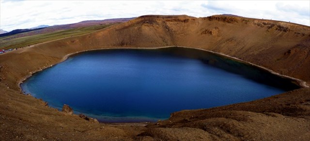
Visit the beautiful Víti crater lake of the Krafla vulcano system.

The icelandic word "víti" means "hell". Nevertheless, this blue-green lake nowadays is everything else but hell.
Sometimes visitors get confused as there is another Víti at Askja.
Víti at Krafla can be easily reached on the tarmacked road. At N 65° 43.060 W 016° 45.470 you'll find the parking area for your cachemobile.
GEOLOGY:
The Víti crater lake belongs to the Krafla volcanic area which is more than 100.000 years old. Krafla itself is a caldera of about 10 km diameter. Askja is the other caldera in North Iceland. Krafla contains a high temperature geothermal field with temperatures exceeding 340°C at 2 km depth.
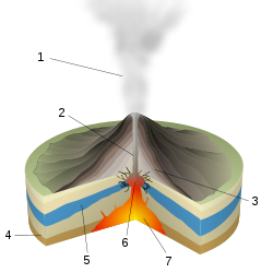
Sketch of the phreatic eruption from Wikipedia.
 |
The crater was formed on 17th May 1724 by a phreatomagmatic explosion. This type of eruption happens, when hot magma reaches ground water. Due to this the water evaporates almost instantaneously and due to the huge amount of water vapor (roughly 1000 times the volume of the liquid water) pressure builds up. This pressure is then released in a phreatic eruption. Mud and rock debris from near surface rocks and tephra, i.e. silicic pumice, and basaltic scoria ejected by the eruption then form the crater. There is usually no lava flow involved. If the crater later fills with water to become a crater lake it is called a maar.
The formation of Víti happened directly at the start of a period of volcanic eruptions - the so-called Mývatn fires (Mývatns-Eldar), which continued for five years until 1729. So that's maybe where the name "Víti" comes from.
It took more than a century until the Víti lake stopped boiling and turned into this beautiful tranquil lake.
LOGGING:
To log this earthcache as a find you have to e-mail us via the profile the answers to the following questions and log immediately. We will contact you, if answers are wrong. Do not post answers in the log or your log will be deleted!
Collect your answers while walking around the crater and record the distance with your GPSr.
PLEASE NOTE: Do not leave the trails to avoid damage to the sensitive tuff ash formation!
If the trail around the crater rim is closed there is good reason for. Do not walk on! Skip question 3 and try to estimate the diameter of the crater lake to answer Q5.
Q1: Examine the ground on the crater rim you are walking on. Explain in a few words how the vesicles in the stones (holes, bubbles, cavities) you can see have formed during the eruption of the crater!
Q2: Describe the color of the lake and develop an idea why it is like that!
At N 65° 42.967 W 016° 44.984:
Q3: Describe what is causing the loud noise and explain how people nowadays make use of the crater geology!
At N 65° 43.060 W 016° 45.415.
Q4: How many stone pillars stand here in a circle?
Q5: What is the circumference of the crater trail?
Although it is not required anymore, please upload a photo of you with your GPSr or the lake in the background to your log. Do not spoil Q4.

Additional Hints
(No hints available.)