Säntis – Der Berg
Da meine Schwiegereltern ein Ferienhäuschen im Toggenburg haben, sind wir regelmässig in der Gegend. Und egal wie oft ich schon hier oben war: Es ist einfach immer wieder schön!
Deshalb möchte ich euch die einzigartige Geologie dieses Berges etwas näher bringen.
Der Alpstein – das „Säntis-Gebirge“
Der Säntis ist der höchste Gipfel des Alpsteins, weshalb der Alpstein oft auch „Säntis-Gerbirge“ genannt wird. Er begrenzt die Alpen im Norden. Aufgrund dieser nördlichen „Vorpostenlage“ mit nur geringer Entfernung zum Bodensee (Luftlinie knapp 30 km) wirken Alpsteinmassiv und Säntis sehr mächtig.
Geformt wurde das Massiv durch die Alpenfaltung, welche die Gesteinsschichten in eine Folge von parallelen Falten und Überschiebungen stauchte. Wie eine Schar brechender Wellen, welche im Moment des Aufbrandens auf eine geneigte Fläche erstarrt sind, zeigt der Säntis die engen Beziehungen zwischen Gesteinsaufbau und Oberflächengestaltung.
Diese Falten kann auf dem Säntis oben sogar der Laie leicht erkennen.
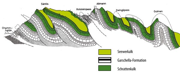
Quelle Abbildung: http://www.bergbahnenwildhaus.ch
Geologisch ist der Alpstein ziemlich einzigartig, da er – anders als die überwiegend aus Granit bestehenden Zentralalpen – ein Kalksteinmassiv ist. Damit stellt er eine Art westliche Fortsetzung der weiter östlich zwischen Deutschland und Österreich verlaufenden nördlichen Kalkalpen dar.
Der Kalkstein ist mit zahlreichen Rissen, Höhlen und Dolinen durchsetzt. Das dadurch abfliessende Wasser führt zu Wassermangel, der von manchen Hütten und Alpen durch das Auffangen von Regenwasser kompensiert werden muss.
Bildung des Alpsteins
Die im Alpstein vorkommenden Sedimentgesteine wurden während eines Zeitraums von rund 100 Millionen Jahren abgelagert: In der Phase vom Erdmittelalter (Jura, Kreide) bis in die Erdneuzeit (Tertiär).
Die Bildung der im Alpstein sichtbaren Gesteine erfolgte im nördlichen Schelfbereich der damals zwischen der eurasischen und afrikanischen Kontinentalplatte liegenden Tethys. Die Sedimente – vor allem durch Organismen gebildeter Kalkstein – wurden in einem subtropischen bis tropischen Klima abgelagert.
Die Verwitterung von Gesteinen des Festlandes führte zur Einschwemmung von Sand und damit zu sandigen Kalken. Die Einschwemmung von Tonmineralien bildete mergelige Ablagerungen. Für die Alpsteinsedimente ist deshalb eine zyklische Kalk-Mergel-Kalk-Schichtung typisch.
Während der Gebirgsbildung wurden die Sedimentablagerungen gegen Norden verschoben, verfaltet und die ursprünglich in verschiedenen Bereichen des Meeres abgelagerten Sedimente übereinander geschoben.
Aufgrund dieser Entstehungsgeschichte, finden sich in den Sedimentablagerungen des Alpsteins versteinerte Reste der ursprünglich im Meer lebenden Organismen. Die Zusammensetzung der Fossilien-Gemeinschaft unterscheidet sich abhängig vom ursprünglichen Ablagerungsraum.
In den sandigen, eher küstennah abgelagerten Schichten, finden sich vor allem Muscheln, in Flachwasserbereichen Korallen und spezielle Muscheln (so genannten Rudisten), in Schelfbereichen Ammoniten und in den Ablagerungen ehemaliger Tiefseegebiete vor allem Kleinorganismen (Foraminiferen).
Die Mineralienausstellung auf dem Säntis
Eine geologische Attraktion erwartet dich direkt hier oben auf dem Säntisgipfel: Die umfangreiche Mineralienausstellung mit zahlreichen Exponaten aus der ganzen Welt – aber auch aus der Alpsteinregion sind einige dabei. Ein Besuch lohnt sich auf jeden Fall, besonders wenn ihr diesen Earthcache loggen möchtet!
Du findest sie, wenn du direkt nach dem Betreten des Bergstation-Gebäudes die Treppe links nimmst und in den ersten Stock gehst. Die Ausstellung ist täglich während der Betriebszeiten der Bergbahn geöffnet. Kostet übrigens keinen Eintritt…
Quellen: Wikipedia, http://www.bergbahnenwildhaus.ch, www.ngw.ch
Logbedingungen
Besuche die Ausstellung um die folgenden Fragen zu beantworten:
- Finde heraus, wie die kleinen Kristalle genannt werden, die man in der Alpstein-Region finden kann. Schick mir bitte den spezifisch hier im Alpstein dafür verwendeten, schweizerdeutschen Begriff (nicht "Calcit"!), den du in der Ausstellung finden kannst.
- Was ist das für ein bunter „Stein“ ist denn der folgende und woher genau stammt er?
- Und wo wurde dieser gefunden?
- Gehe nun nach draussen zum Referenzpunkt. Wende deinen Blick Richtung Südosten (Richtung Lisengrat) und beschreibe Struktur und Farbe der gefalteten Gesteinsschichten so genau wie möglich.
Fotolog-Bedingungen sind ja mittlerweile nicht mehr erlaubt. Dennoch würde ich sehr freuen, wenn du ein Foto von dir und deinem GPS mit den eindrücklich gefalteten Gesteinsschichten im Hintergrund machst.
Sende mir die Antworten zu obigen Fragen. Schreibe die Antworten bitte nicht in den Log! Du darfst den Cache sofort loggen und musst nicht auf die Freigabe warten. Sollte etwas mit den Antworten nicht stimmen, werde ich mich melden.
Viel Spass und weiterhin Happy Caching!
Säntis – The Mountain
As my parents-in-law own a small holiday home in the Toggenburg region, we are regularly in the area. And no matter how many times I have already been up here: It is a pleasure again and again!
Therefore I would like to give you an introduction to the unique geology of this mountain.
The Alpstein – the “Säntis Mountains”
The Säntis is the highest peak of the Alpstein, which is the reason why the Alpstein is often called the “Säntis Mountains”. It forms the north boundary of the Alps. Due to its northern “outpost” situation, which is only in a short distance from the Lake Constance (less than 30km air line), the Alpstein massif and the Säntis make a very dominant impression.
The massif was formed by the folding of the Alps, which compressed the rock strata into a series of foldings and overthrusts. Like a clutch of breaking waves, which solidified just in the moment they hit an inclined surface, the Säntis demonstrates the close relationship between rock structuring and building of the surface.
Those foldings can easily been identified even by a layperson up on the Säntis.
Figure source: http://www.bergbahnenwildhaus.ch
Geologically the Alpstein is quite unique, as it is a lime rock massif. This differs it from the mostly of granite consisting Central Alps. It can therefore be considered as some kind of a western continuation of the farther east running Calcareous Alps between Germany and Austria.
The lime rock is interstratified with breaks, caves and sinkholes. The water which therefore drains off leads to water shortage, which is compensated by some huts and alps by collecting rainwater.
Formation of the Alpstein
The sedimentary rocks in the Alpstein were deposited over an era of around 100 million years: In the period from the Mesozoic era (Jura, Cretaceous) to the Cenozoic (Tertiary).
The rocks, which are visible in the Alpstein, were formed in the northern shelf area of the Tethys, the ocean which lay between the Eurasian and the African tectonic plates at that time. The sediments – mainly lime rock built by organisms – were deposited in a semi-tropical to tropical climate.
The alteration of rocks on the mainland led to flooding of sand and consequently to sandy lime rocks. The flooding of clay minerals on the other hand formed marly deposits. For this reason cyclic lime rock - clay - limerock stratification is characteristic for the sediments in the Alpstein.
During the formation of the Alps the sediment discharges were shifted northwards, folded and the initially in different areas of the ocean deposited sediments were pushed over each other.
Due to this formation history fossil remains of the originally in the ocean living organisms can be found in the sediment discharges of the Alpstein. The composition of the fossil collective differs dependent from the original deposition location.
In the sandy, rather offshore deposited layers mainly mussels can be found, in the shallow water zones corals and special mussels (so called rudists), in the shelf areas ammonites and in the sediments of former high sea areas small organisms (foraminifers).
The mineral exhibition on the Säntis
A geological sensation is waiting for you directly up here on the Säntis summit: An extensive mineral exhibition with numerous exhibits from all over the world – but there are also some from the Alpstein region. It is definitely worth visiting, especially if you want to log this earth cache!
You will find it, if you take the stairs to your left directly after entering the mountain station. Go up to the first floor. The exhibition is open daily during the operating time of the cable car. The entrance is free of charge by the way.
Sources: Wikipedia, http://www.bergbahnenwildhaus.ch, www.ngw.ch
Log requirements
Visit the exhibition in order to answer the following questions:
- Find out how the little crystals are called, which can be found in the Alpstein region. Please send me the term, which is specifically used in the Alpstein region (not "Calcite"!). You can find the term in the exhibition.
- What kind of colourful “stone” is the following and where exactly does it originate from?
- And where was this one found?
- Go outside to the reference point. Look towards southeast (towards the Lisengrat) and describe the structure and color of the folded strata as exactly as possible.
Photo-log requirements are not allowed anymore. Nevertheless I would be happy, if you took a picture of you and your GPS device with the impressive strata in the background.
Send me the answers to the above questions. Please do not write the answers into your log. You can log the cache immediately; you don’t need to wait my approval. I will get in touch to you, if there is anything wrong with your answers.
Have fun and happy caching!