TFGT: Freshwater Flight Traditional Geocache
-
Difficulty:
-

-
Terrain:
-

Size:  (small)
Please note Use of geocaching.com services is subject to the terms and conditions
in our disclaimer.
Anyone can claim this cache, but to be eligible for the Taking Flight Geo Tag you will need to be a careful observer as you make your way up river to the cache site. Be sure to log your visit, and count the number of birds you see while on the trip. Record your findings in your Passport.
This cache is accessible only by water. It is located in Twin Rivers Preserve, a preserve that is not currently open to the public but has been made accessible for this cache. It is on land, but you will need to paddle to get there. Also, on land there are no set trails so please be careful as you move through the landscape. Please consider using the trip you make to find this cache as an opportunity to make a positive impact on Florida’s waterways and improve habitat for local wildlife. As you paddle or boat to the cache site location, please participate in “trashing out” as you cache in. Please take a moment to collect any trash that you see on the water, removing potential hazards for wildlife. Participating in a “cache in, trash out” is a favorite event of geocachers and one of the many ways cachers help care for the lands they visit while looking for caches.
For this cache you’ll have to make like a heron and fly up the Manatee River to Gamble Creek Preserve. This is a new site not yet open to the public, but you can certainly explore while it is undergoing restoration by paddling the maze of creeks that split off through the land mass. Along the way, keep your eyes peeled for the different wading birds commonly found along the Manatee River’s shore.
As you travel up the Manatee River and into Gamble Creek, an offshoot of the lower Manatee River, your river cruise is on one of Florida’s blackwater rivers. Because this type of river drains areas that have lots of trees, the water is colored from the tree leaves and tannin. At Gamble Creek, the water is freshwater but the connectingManatee River is also a tributary of Tampa Bay, feeding into the saltwater body, creating an estuary at the place where the river feeds into the Bay. Gamble Creek is part of the Manatee River watershed, and at this point drains into Tampa Bay. This watershed spans 351 square miles and includes 25 named lakes and ponds, 39 named rivers, streams, and canals, and 2 named Bays. All of the homes and businesses located in the land of the Manatee River Watershed play a role in impacting the water bodies and the bay into which they drain.
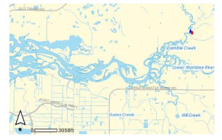
Gamble Creek feeding into the Lower Manatee River. Map courtesy Manatee County Water Atlas
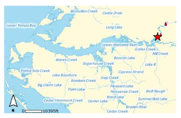
The Manatee River (Gamble Creek indicated by star). Map courtesy Manatee Water Atlas
As you travel up river, the water becomes progressively fresher and the wildlife and plant communities change accordingly. This means that you may see birds here that are unique to a habitat found around freshwater rivers, including the rare limpkin, as well as birds that are “flyovers” moving from the coast inland or out to the coast. You may also see birds that are stopping in the area to hunt for food as well as those “regulars” that live within this particular habitat. But how can you tell which one is which?
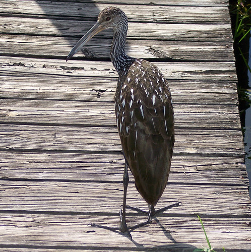
A limpkin. Photo by Neitherday
The easiest way to learn to identify birds is by looking at their body plan. The overall structure, size, and shape of the bird can provide a clue as to the type of bird, as can the color of its body, wings, tail and head. A bird’s behavior, habitat, songs, and calls are also excellent markers that will help to identify it. Start by considering the silhouette of the bird – this will help you to decide what type of bird you have sighted. From there you can use the colors of the bird to look it up in a field guide to get a positive identification.

Great Blue Heron Silhouette from Cornell’s All About Birds website
Plan your trip so that you can spot the birds! It’s a good idea to take a pair of binoculars with you (especially waterproof ones). Go when the birds will be most active too – early morning is a great time to spot birds. Try to talk softly and to limit noise so that the birds will not be scared away. And consider the time as different birds are present throughout the year.
As you look for birds, keep these tips in mind:
- Watch the bird – don’t immediately look it up; take the time to really look at the details in case it quickly flies away
- Estimate general shape and size – getting an approximate idea of these two major characteristics will help you narrow down the type of bird
- Listen for calls and songs – some birds are easily identified by what they have to say
- Look for facial markings and bill characteristics – these are two color and body plan characteristics that can be especially helpful when trying to identify a bird
- Look for wing bars and tail shape – these are two other color and marking characteristics that can be especially helpful when trying to identify a bird
- Consider the bird’s location – where did you see the bird? It’s habitat can give clues as to the type
Anyone can claim this cache, but to be eligible for the Taking Flight Geo Tag you will need to be a careful observer as you make your way up river to the cache site. Be sure to log your visit, and count the number of birds you see while on the trip. Record your findings in your Passport.
Visit the sites along the Taking Flight GeoTour (TFGT) and learn about Manatee County’s wild spaces and the amazing feathered friends that live in them. Along the way, you will be challenged to become a citizen scientist, a preserve ranger, a detective, a historian, and of course an excellent geocacher in order to find all of the caches in the trail. Caches are located in birding “hot spots” throughout Manatee County’s publicly accessible conservation preserves. Each one highlights a specific bird species or aspect of bird life providing you with opportunities to learn more about these creatures and what we can do to help them survive. Caches also focus on protecting the region's waterways, bays, and natural watersheds, and habitat areas for many of our area’s feathered fliers.
The Taking Flight GeoTour includes 20 caches within Manatee County. A custom Taking Flight Geo Tour trackable geo tag will be awarded for locating at least 12 TFGT caches. To be eligible for the tag, geocachers must download a passport from the TFGT Website or pick one up at the Manatee County Natural Parks & Natural Resources Department office at GT Bray Park 5502 33 rd Ave. Dr. W., Bradenton, FL., Monday through Friday, 9 a.m. to 4 p.m. Geocachers must log at least 12 finds, answer the question from each cache on their passport, and complete any additional requirements for specific caches (such as posting photos for earth caches). After finding a minimum of 12 caches, participants can have their passports validated in person or via mail at the Manatee County Natural Parks & Natural Resources Department office at GT Bray Park 5502 33 rd Ave. Dr. W., Bradenton, FL 34209, Monday through Friday, 9 a.m. to 4 p.m. News and updates on tag availability and validation hours can be found online at the Parks & Natural Resources Department's website.
Thank you for assisting with the Taking Flight GeoTour:
Additional Hints
(Decrypt)
Qba'g trg oheag bhg ybbxvat sbe guvf bar