Welcome to Riverview Pointe Preserve!
Anyone can claim this cache, but to be eligible for the Taking Flight Geo Tag you must: Write down the "magic number" you get from adding the dates on the photos together. Be sure to include this number in your passport.
FINAL COORDINATES: N27 31.(157 + Number) W82 38.(551 + Number)
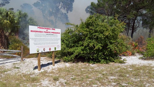
At only 11 acres, Riverview Pointe is one of Manatee County’s smallest preserve sites. But Riverview Pointe has some pretty unique habitats for such a small area, including the extremely rare coastal scrub habitat, the oak-filled hardwood hammock, and the coastal mangrove forest. Riverview Pointe sits in a unique location, on one side it is adjacent to DeSoto National Memorial and on two other sides it is pressed against private residences. This preserve is part of the urban landscape and the rangers who manage it must keep this in mind as they work to care for the land.
In March of 2011, the Natural Resources Department’s rangers teamed up with staff from DeSoto National Memorial, West Manatee Fire Department, and the Department’s own volunteers in order to conduct a prescribed burn at the site. Why intentionally set the landscape on fire? Fire is an important part of Florida’s natural cycle. Especially in the scrub habitat, fire is necessary for plants to grow, seeds to sprout, to eliminate built up piles of fuel, and to maintain the habitat for the resident wildlife.
The rangers who conduct the burns in Manatee County have all received training and each burn event is managed by a “Burn Boss” who must craft a prescription plan for the burn. The plan includes a map of the site, weather considerations, and method of how the fire will be applied to the landscape. The rangers also plan out “fire breaks,” which can be natural features such as the Manatee River on the preserve’s northern border or man-made structures such as the road to its south. These fire breaks are paths which will stop the movement of the fire and contain it within the planned area. All of these elements are part of the plan the rangers must make before any fire is put onto the ground.
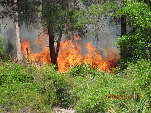
This type of burn, located within a neighborhood, is considered to be one in the urban interface. Because Riverview Pointe was so close to a neighborhood, County staff reached out to a number of different partner organizations and also the local homeowner’s associations in order to educate and explain the plan. Several months of planning with multiple agencies led to a very successful burn. The photos below showcase the day’s progression.

Pre-burn meeting. Photo by Aedan Stockdale

Monitoring the fire. Photo by Aedan Stockdale
Prescribed fire at Riverview Pointe Preserve. Photo by Aedan Stockdale

Burn "mop-up" by Aedan Stockdale
The first listed coordinates will take you to one of the photopoints for the burn. These points were established immediately following the burn in order to track the progress of growth at different sites within the burned area. A total of five points were set, and each month volunteers Rob Hamilton and Vicki Jarratt visited the points and photographed the re-emergence of vegetation at the site and the changes to the landscape.
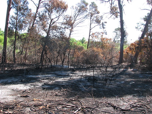
Riverview Pointe after the prescribed fire
It may be hard to believe, but from the burned landscape an entirely new habitat was born. For the wildlife that live at the site this means new shelter, fresh new shoots and leaves to eat, and new plant species that spring up from the seed source in the soil. After a fire, there is often an abundance of insects and birds such as swallows, screech owls, and shrikes can be seen eagerly capturing snacks. With the old overgrowth removed, a greater diversity, or number of types, of plants will reappear attracting even more bird species. Fire moves through the landscape in a mosaic pattern, and since not everything is burned, small islands of habitat are left unscorched as shelter for wildlife. These areas provide cover and food for creatures as the other portions of the land grow in. The landscape bounces back quickly, often turning green within two or three days of the burn.
Within the first cache of this two part multi-cache, you will find four photos showing the progression of growth from the initial date of burning to nearly one year later. Add up the dates on each photo (using the numerical value for each day, but not the month and year) and use it in the formula below in order to find the actual hiding spot for this cache.
FINAL COORDINATES: N27 31.(157 + Number) W82 38.(551 + Number)
When you reach the final cache location, take a moment to look around. This area, too, was completely burned during the prescribed fire and only a short time later has already grown back. Can you spot any evidence that a fire happened here? The changes that have happened here have been human-made changes that are helpful to the landscape. Anyone can claim this cache, but to be eligible for the Taking Flight Geo Tag you must:
- Write down the "magic number" you get from adding the dates on the photos together. Be sure to include this number in your passport.
2. Take a photo of the second cache site and submit it with your log on the cache page. This will help track the continued progression of growth at the site. Bonus points for any birds you spot at the site!
Visit the sites along the Taking Flight GeoTour (TFGT) and learn about Manatee County’s wild spaces and the amazing feathered friends that live in them. Along the way, you will be challenged to become a citizen scientist, a preserve ranger, a detective, a historian, and of course an excellent geocacher in order to find all of the caches in the trail. Caches are located in birding “hot spots” throughout Manatee County’s publicly accessible conservation preserves. Each one highlights a specific bird species or aspect of bird life providing you with opportunities to learn more about these creatures and what we can do to help them survive. Caches also focus on protecting the region's waterways, bays, and natural watersheds, and habitat areas for many of our area’s feathered fliers.
The Taking Flight GeoTour includes 20 caches within Manatee County. A custom Taking Flight Geo Tour trackable geo tag will be awarded for locating at least 12 TFGT caches. To be eligible for the tag, geocachers must download a passport from the TFGT Website or pick one up at the Manatee County Natural Parks & Natural Resources Department office at GT Bray Park 5502 33 rd Ave. Dr. W., Bradenton, FL., Monday through Friday, 9 a.m. to 4 p.m. Geocachers must log at least 12 finds, answer the question from each cache on their passport, and complete any additional requirements for specific caches (such as posting photos for earth caches). After finding a minimum of 12 caches, participants can have their passports validated in person or via mail at the Manatee County Natural Parks & Natural Resources Department office at GT Bray Park 5502 33 rd Ave. Dr. W., Bradenton, FL 34209, Monday through Friday, 9 a.m. to 4 p.m. News and updates on tag availability and validation hours can be found online at the Parks & Natural Resources Department's website.
Thank you for assisting with the Taking Flight GeoTour: