TFGT: Flooded Flight EarthCache
-
Difficulty:
-

-
Terrain:
-

Size:  (other)
Related Web Page
Please note Use of geocaching.com services is subject to the terms and conditions
in our disclaimer.
Part of the Taking Flight GeoTour, this is an Earthcache that teaches about sea level rise and its potential impact on nesting bird habitat, and challenges finders to become citizen scientists.
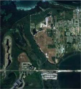
Welcome to Robinson Preserve!
Robinson Preserve is one of Manatee County’s most popular conservation properties with a visitation of over 30,000 people during its busiest months. People love to come here to jog, ride bikes, or walk their dogs on the 3 miles of paved and hard packed shell trails, paddle on the 2 miles of water “blueways” trails, scale the 40-foot tall observation tower, visit the circa 1900‘s Valentine House Visitor’s Center, fish, or birdwatch in the many boardwalks and wildlife viewing areas. The 487-acre conservation preserve site is home to one of the rarest habitats in the Tampa and Sarasota Bay region: the salt marsh, along with mangrove forests and coastal uplands habitat. These habitats support a diverse selection of plants and also attract a variety of wildlife species, including extremely rare animals such as roseate spoonbills, wood storks, and least terns. The habitat provides these creatures with food and shelter and, in some cases, a place to nest and raise families too.
But what would happen if the landscape dramatically changed? If the fragile salt marsh habitat was under water, where would the least terns nest? Where would the white ibis and other wading birds find food if they could not snatch up the fiddler crabs that burrow into the barren salt flats? How could these rare creatures be protected, and how could the land be preserved? This is the question facing scientists, land managers, and rangers today as more information about sea level rise is being collected. As our collective understanding about changing levels of the world’s oceans increases, Manatee County’s rangers are faced with the problem of trying to plan for potential changes that are very difficult to predict.
Many people argue about whether or not sea level rise is a real problem, but Florida’s historical and geological record reveal that the state’s landform and waterways have experienced radical changes over time. Over 3 million years ago, much of Florida was underwater and the land was only revealed as the process of glaciation locked up much of the world’s water. As the world’s seas receded, more of Florida’s land mass was uncovered. Florida’s land mass is rich in rivers, lakes, and sink holes which lead to the underground aquifer deep beneath the surface. It is a land of water, supporting our own human culture by providing opportunities for exploration, obtaining food, traveling across the state, and seeking entertainment. We have depended upon our state’s water resources for hundreds of years, and over time we ourselves have affected the shape and structure of these waterways by creating dams, dredging, and constructing ditches. Each of these activities has affected the flow and shape of the waterways and their surrounding natural habitats, oftentimes with prices that we cannot fully imagine. As the state’s land has developed, and we humans have impacted the water, there have also been natural changes to the landscape. Hurricanes bring in great winds and rain, flooding the earth and reshaping the barrier islands. Rivers change their courses, slowly over time, eroding natural banks and reshaping their own paths. And far away to the north, ice melts as part of the natural process, adding water to the oceans and minutely increasing the level of our seas.
But what happens if our own activities provide a catalyst to the natural processes, speeding them up and possibly even adding to the effects? What happens in a place where we’ve lived dependent upon the Gulf, Ocean, bays, lakes, rivers, and streams, when the world’s waters change? Scientists cannot say for certain when sea level rise will occur, nor can they predict exactly what will happen. Programs like the National Estuary Programs can, however, look at past data and current trends to create models that tell us what we can expect within our area. The Sarasota Bay Estuary Program (SBEP) has worked with Mote Marine Lab, U.S. Environmental Protection Agency, ManateeCounty, and Sarasota County in order to create a map that predicts what could happen if sea level rise occurs in the local area. The model shows the current water levels at Robinson Preserve:
As well as what might happen with 1 foot, 3 feet, and 6 feet of sea level rise:
These maps can also tell us what may happen with a storm surge. Here’s the same prediction with a storm surge, which can occur during or after a tropical storm or hurricane (6 feet of storm surge):
How probable is it that this could happen? Robinson Preserve’s iconic observation tower became its own island due to storm surge after the June 2012 tropical storm Debbie:
Storm surge at Robinson Preserve June 2012 after Tropical Storm Debbie (top: normal landscape at observation tower boardwalk, bottom: storm surge at same location):
What do these predictions tell us? It’s important to remember that these models are created not to scare us but to help us learn how we can adapt and plan for these potential effects. SBEP’s map can help us learn how to protect our coastal homes and businesses as well as how to adapt coastal conservation properties like Robinson Preserve. The functions of the salt marsh habitat, predicted by the models to be underwater with 3 or more feet of sea level rise, can be replicated with a bit of help from land managers. Already, rangers are installing floating islands that can survive rising water levels and serve as nesting platforms for birds like least terns. Rangers are also installing oyster beds under the water which, in time, can provide food resources for wading birds. By taking steps now to prepare for potential changes, we can protect our local bird populations in the future.
This Earthcache challenges you to become a "citizen scientist" and help collect data to track sea level rise at Robinson Preserve. The data that you collect will be tracked over time in order to determine the current amount of sea level rise at the site and to make future decisions about protecting the site. To complete the cache, please do the following:
- Visit the cache site and collect the following data and post it in your cache log and write it in your passport:
- Date of visit
- Time of visit
- Whether the tide was in or out and the height of the tide (to determine this, view tide charts)
2. Optional: Take a photo of yourself at the cache site and post it in the gallery (try to get a photo that includes the tide line at the time) Please respect the habitat and keep it safe - do NOT go off trail to snap your photo!
3. Record the number of birds at the site in your passport - look for fly-overs, birds in the water, and those on land too. Send a more detailed description to the cache owner. Pay careful attention to their behavior. Are there more birds in the water areas? Do you notice different types? How might sea level rise at the site affect these creatures? Extra credit if you can identify the birds and/or include photos as this will help document the species reaction to the changing waters at the site.
4. Look around for evidence of fluctuations in water level. While it is true that the tides change here regularly, storm surge events can have a major impact on the geography and a rising sea level will also transform the landscape, even at the most minute levels. Can you find any evidence of changes? Here's a hint: look at plant growth, the tide line, and possible spots of erosion. Describe anything you find in detail and please send this information to the cache owner. Posting photos of potential changes to the landscape is optional but encouraged!
Visit the sites along the Taking Flight GeoTour (TFGT) and learn about Manatee County’s wild spaces and the amazing feathered friends that live in them. Along the way, you will be challenged to become a citizen scientist, a preserve ranger, a detective, a historian, and of course an excellent geocacher in order to find all of the caches in the trail. Caches are located in birding “hot spots” throughout Manatee County’s publicly accessible conservation preserves. Each one highlights a specific bird species or aspect of bird life providing you with opportunities to learn more about these creatures and what we can do to help them survive. Caches also focus on protecting the region's waterways, bays, and natural watersheds, and habitat areas for many of our area’s feathered fliers.
The Taking Flight GeoTour includes 20 caches within Manatee County. A custom Taking Flight Geo Tour trackable geo tag will be awarded for locating at least 12 TFGT caches. To be eligible for the tag, geocachers must download a passport from the TFGT Website or pick one up at the Manatee County Natural Parks & Natural Resources Department office at GT Bray Park 5502 33 rd Ave. Dr. W., Bradenton, FL., Monday through Friday, 9 a.m. to 4 p.m. Geocachers must log at least 12 finds, answer the question from each cache on their passport, and complete any additional requirements for specific caches (such as posting photos for earth caches). After finding a minimum of 12 caches, participants can have their passports validated in person or via mail at the Manatee County Natural Parks & Natural Resources Department office at GT Bray Park 5502 33 rd Ave. Dr. W., Bradenton, FL 34209, Monday through Friday, 9 a.m. to 4 p.m. News and updates on tag availability and validation hours can be found online at the Parks & Natural Resources Department's website.
Thank you for assisting with the Taking Flight GeoTour:
Additional Hints
(Decrypt)
Evtug arne gur orfg ivrj nebhaq