360º View - Serra do Açor - VG Chama
 |
|
| Português |
English |
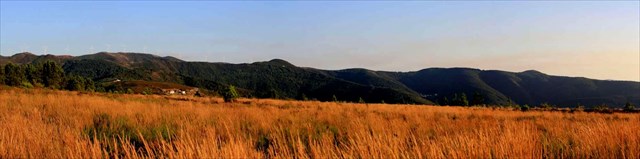
| A Serra do Açor |
Mountains of the Serra do Açor |
|
A Serra do Açor é uma serra no centro de Portugal, junto à Serra da Estrela, que abrange vários concelhos como Oliveira do Hospital, Arganil ou Tábua e onde se localizam freguesias históricas como o Piódão ou São Gião.
A Serra do Açor faz parte da Cordilheira Central, de que fazem parte a Serra da Lousã, Açor e Serra da Estrela. Tem vários pontos de grande elevação, de que se destacam, O Monte do Colcurinho (1242 m de altitude), o Alto de S. Pedro (1341 m), Alto Ceira e o Pico de Cebola (com cerca de 1400 m), ponto mais alto do distrito de Coimbra. Todos este locais, são zonas de grande beleza e pontos de interesse turístico a visitar. Aí se situa a área de Paisagem Protegida da Serra de Açor. |
The beautiful mountains of the Serra do Açor are located west from the vast area of the Serra da Estrela. In contrast with this highest chain of mountains of Portugal, that consists principally of granite, schist is the characteristic stone of the Serra do Açor. Schist was the basic building material for the picturesque houses of the many, formerly isolated villages and hamlets. The barbarous vegetation is rich in majestic chestnut-trees, oak, pine, eucalyptus and some olive trees. Amongst the shrubs, heather, rosemary, yellow-flowered broom and furze, stand out. There is an abundance of water from streams that spring from the mountains.
|
 |
| A cache |
The cache |
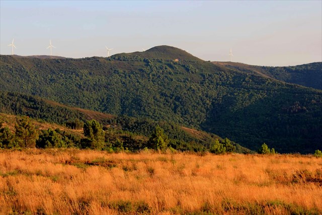
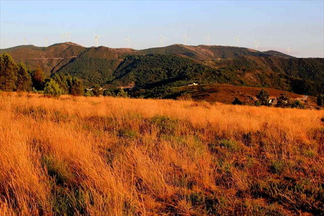
O local onde se encontra esta cache está a cerca de 770 m de altitude, com excelentes vistas, quer para as montanhas em redor, como para paisagens mais longínquas.
Trata-se de um contentor micro, que apenas se destina a "marcar" este local, pelo que quem não estiver interessado em disfrutar da natureza e ter um argumento para uma visita, não vale a pena vir, pois não é um contentor grande, não é bem elaborado, é só para assinar e depois apreciar!
O acesso, nos últimos 2 Km é feito por estrada de terra batida, mas a mesma encontra-se em muito boas condições de circulação. |
The location of this cache is about 770 m altitude, with excellent views either to the mountains around, and for more distant landscapes.
This is a micro container, which is only to "bookmark" the site and therefore if you are not interested in enjoy nature and have an argument for a visit this spot, it doesn’t worth to come because this is not a large container, is not well prepared, it is just to sign and then enjoy!
The access in the last 2 km is by dirt road, but it is in very good conditions of service.
|
 |
| Vértices Geodésicos |
Geodesic vertices |
|
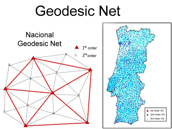
Conjunto de todos os vértices geodésicos e das suas relações geométricas, distribuídos pelo país, colocados em posições dominantes de forma a garantir intervisibilidade, devidamente coordenados. Estão materializados através de diversas formas geométricas, como pirâmides ou troncos de cone sobre cilindros (bolembreanas) ou são coincidentes com estruturas já existentes.
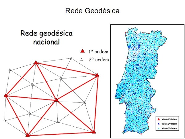
Um VG ou vértice geodésico (popularmente chamado "talefe" em Portugal, e "Pinoco" no Norte de Portugal) é um sinal que indica uma posição cartográfica exacta e que forma parte de uma rede de triângulos com outros vértices geodésicos. São escolhidos sítios altos e isolados com linha de visão para outros vértices. A rede geodésica portuguesa é formada por vértices geodésicos que se dividem em três ordens de importância:
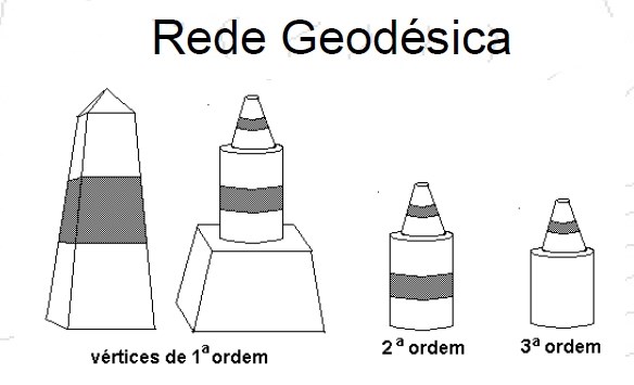
1ª Ordem - pirâmides distando 30 a 60 km
2ª Ordem - cilindro + cone listados distando 20 a 30 km
3ª Ordem - cilindro + cone distando 5 a 10 km
O número de vértices existentes na totalidade do território (Portugal Continental e Regiões Autónomas) é, actualmente, de cerca de nove mil, repartidos por vértices de: Continente: 1ª Ordem (cerca de 120), 2ª Ordem (cerca de 900) e 3ª Ordem (com uma densidade aproximada de 1 vértice por cada 10 km²) Arquipélago dos Açores: cerca de 500 Arquipélago da Madeira: cerca de 150 A RGN é a infra-estrutura básica onde se apoia toda a cartografia do País, e que serve todos aqueles (empresas, autarquias e outros organismos públicos e privados) que, por força das suas actividades, necessitam de referenciar geograficamente os seus projectos (os Planos Directores Municipais, por exemplo). |
Set of all the geodesic vertices and its geometric relations, distributed in the country, placed in dominant form positions to guarantee intervisibilidade, duly coordinate. They are materialized through diverse geometric forms: as pyramids or trunks of cone on cylinders (bolembreanas) or are coincident with already existing structures (curches, lighthouses monuments etc etc.)
A VG or geodesic vertex (popularly called " talefe" in Portugal, and " Pinoco" in the North of Portugal) it is a signal that indicates a cartographic position exacta and that it forms part of a net of triangles with other geodesic vertices. High and isolated small places with line of vision for other vertices are chosen. The Portuguese geodesic net is formed by geodesic vertices that are divide in three orders of importance:
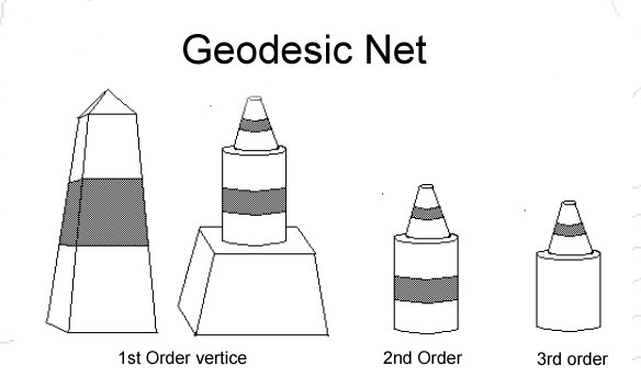
1st Order - pyramids apart betwenn 30 km and 60km
2nd Order - cylinder + cone apart 20 to 30 km
3rd Order - cylinder + cone apart 5 to 10 km
The number of existing vertices in the totality of the territory (Continental Portugal and Autonomous Regions) is, currently, of about nine a thousand, distributed for vertices of: Continent: 1ª Order (about 120), 2ª Order (about 900) and 3ª Order (with an approach density of 1 vertex for each 10 km ²) Archipelago of the Açores: about 500 Archipelago of Madeira: about 150 the RGN is the basic infrastructure where if the cartography of the Country supports all, and that it serves all those (public and private companies, autarchies and other organisms) that, for force of its activities, they need to mention its geographically projects (the Municipal Director Plan, for example).
|