Brooker Creek Preserve Earthcache
At approximately 8,700 acres in size, Brooker Creek Preserve is the largest remaining wilderness area in Pinellas County. The Preserve provides refuge for native flora and fauna and consists of a wide variety of habitats, soil types, and landscapes. Surrounded by urban development, the Preserve is an important natural resource and serves to protect the primary stream that feeds Lake Tarpon. The hiking trails at Brooker Creek Preserve are open from 7:00 am until approximately one hour before sunset and are a quiet place to stroll and offer citizens a unique opportunity to experience the natural beauty that Florida has to offer.
First coordinates: 28° 7’ 51” N 82° 39’ 22” W
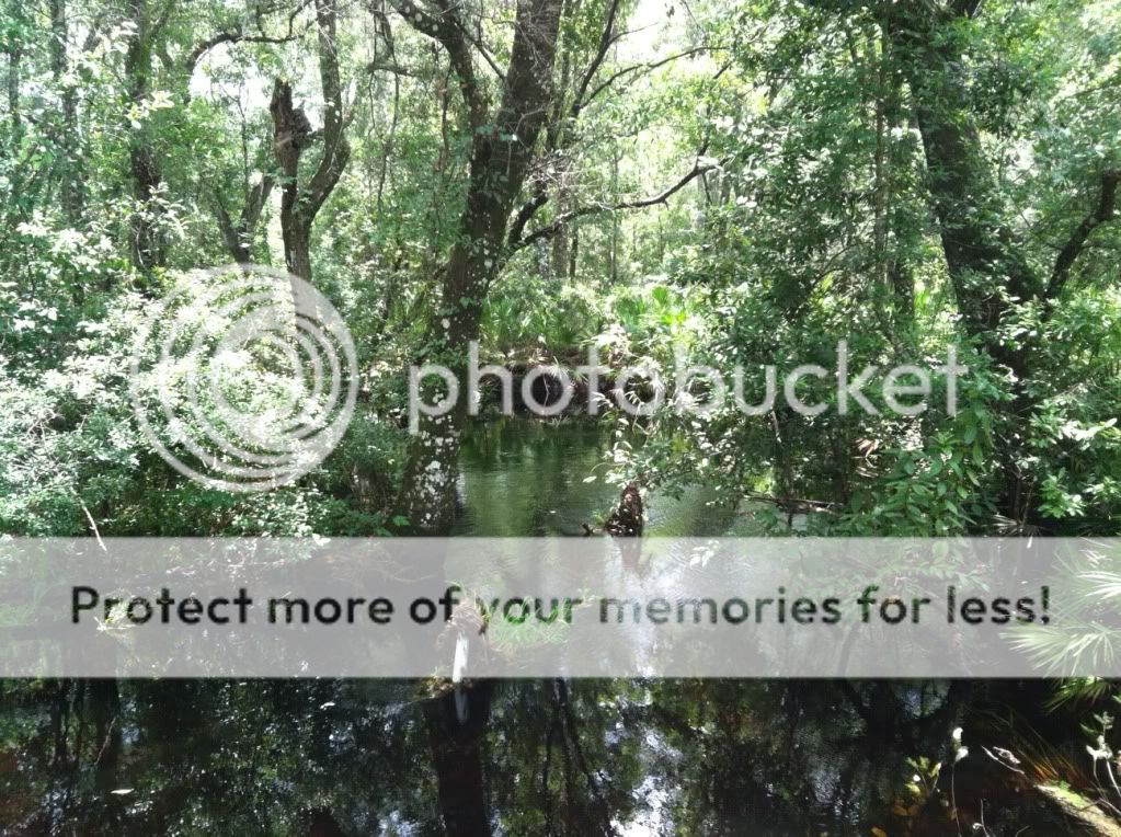 As you stand on the bridge, the stream you are currently observing is Brooker Creek. The creek system is composed of 13 meandering channels that eventually flow together before emptying into Lake Tarpon (just west of the Preserve) as well as the surrounding wetlands. The health of these wetlands and the diversity of plant and animal life within them depend on the hydrology of the creek. As you walk along above the creek you may observe ferns, pileated woodpeckers, dragonflies, water snakes, and alligators. Since Brooker Creek is not fed from a spring, it depends on rainfall and water collection from within its entire watershed for its hydrology. The creek goes through wet and dry cycles and most of the channels may completely dry out before summer rains come to replenish them. All the land on Earth is divided into watersheds that feed into rivers, springs, lakes, wetlands, estuaries, coastal zones, and aquifers, from which a vast majority of Floridians get their drinking water. Contamination occurs as runoff water flows through agricultural, urbanized, and other developed areas, picking up chemicals, bacteria, and other pollutants before draining into a body of water. Actions in the developed areas upstream impact the quality and quantity of water that reaches the preserve.
First Logging Requirement: At one end of the bridge you will see a sign labeled “Good Watershed Choices”. From this sign, please write some actions you can take to protect your watershed.
Second coordinates: 28° 7’ 40” N 82° 39’ 20” W
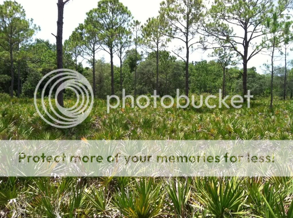 At this location you will find the Flatwoods Shelter. Pine flatwoods are the most common type of upland habitat in Florida. The sandy surface layer of this ecosystem is low in nutrients and organic matter and has an underlying clay layer about 2-3 feet deep that greatly restricts the downward movement of water and plant roots. As you look out from the Flatwoods Shelter you will see widely spaced pine trees and a shrub layer of saw palmettos. These plants are adapted to low nutrient levels and shallow root systems caused by the sandy soil and the clay hardpan. Regular fires play a major role in maintaining this community. Fires stop litter from accumulating and keep the palmettos as a low shrub and allows for a wider diversity of grasses and wildflowers. This diversity in the understory provides food and cover for wildlife. White-tailed deer, bobcats, wild turkey, songbirds, vultures and gopher tortoises are some of the many animals that make use of the flatwoods.
Second Logging Requirement: On the trail outside of the Flatwoods Shelter there is a sign labeled “Plants that Need Fire”. Based on this sign and the information given on this page, how do you think regular fires impact the make-up of the soil to help maintain the pine flatwoods ecosystem?
Third coordinates: 28° 7’ 49” N 82° 39’ 30” W
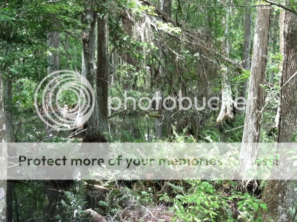 As you walk to this location from the Flatwoods Shelter, notice how the habitat changes from flatwoods to oak hammock to wetlands. This rapid change in landscape can be attributed to slight changes in elevation as you continue along the trail. Hammocks have ample shade provided by the towering oaks and are home to the gopher tortoise, Florida mouse, and eastern diamondback rattlesnake. When you arrive at the coordinates you will be standing on a boardwalk in the swamp ecosystem. Swamps are forested wetlands that occur in areas where the soil is flooded for part of the year. The most common type of wetland tree in Brooker Creek is the cypress. The term “cypress dome” refers to the profile shape of the forest. The center of the swamp is deeper and accumulates the most peat so the tallest trees grow here where there are the most nutrients. The shortest trees grow at the edges, giving the forest a dome-like profile. Swamps hold water for long periods of time so they are important for absorbing rainfall, recharging aquifers, and controlling floods. As you make your way along the boardwalk keep an eye out for swamp ferns, barking treefrogs, palamedes swallowtails, red-shouldered hawks, white ibis, pileated woodpeckers, and the many other plants and animals that live and forage here.
Third Logging Requirement: Along the boardwalk at the coordinates you will find a sign labeled “Swamp Gifts”. From this sign, what is a beneficial service that swamps provide us with?
Congratulations, you have completed the Brooker Creek Preserve Earthcache Tour! We would greatly appreciate it if you could fill out a short survey about your experience: Click Here for Survey