La Gruta Multi-cache
-
Difficulty:
-

-
Terrain:
-

Size:  (small)
Please note Use of geocaching.com services is subject to the terms and conditions
in our disclaimer.
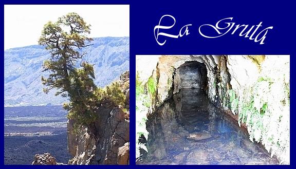
Ziel ist eine wasserreiche Grotte am Rande der Caldera. Der Weg ist gut gekennzeichnet, zuerst mit Schildern, am Schluß mit Farbpunkten. Er muß nicht verlassen werden. Man benötigt ca. 2 Stunden bis zur Grotte.
El fin es una gruta con agua mucha al borde de la caldera del Teide. El sendero bien seañalizado - no puedes extraviarse. Necesitan aproximadamente 2 horas hasta la gruta.
The target is a water-rich grotto on the edge of the caldera. You must not leave the marked official trail.The trail is well marked - first by signs, later by color points. The hike to the grotto takes about 2 hours.
Parken /possibility of parking / posibilidad de aparcamiento = N28°12.850 W016°40.700
1. Start / Viewpoint / Mirador: N28°12.773 W016°40.876
Lies die Daten von der Infotafel des Mirador /Write down the needed data from the viewpoint.../Nota las informaciones de las tablas de mirador
A = (Letzte Ziffer der hier genannten Höhe des Pico Viejo) - 1
A = (The last digit of the height of the Pico Viejo) - 1
A = (El digito ultimo de la altitud del Pico Viejo)- 1
B = (Anzahl Autoparkplätze) - (Anzahl Busparklätze)
B = (number of the parking slots for cars) - (number of the parking slots for buses)
B = (el numero de aparcamientos para coches) - (el numero de aparcamientos de autobús)
G = Anzahl der abgebildeten Menschen auf der Infotafel
G = number of the human beings shown on the info panel
G = ¿cuántos personas puedes ver en la tabla de informaciones?
H = Anzahl der Buchstaben des Vor- und Nachnamens des letzten Hirten
H = number of the letters of the first and last name of the last herdsman in the caldera
H = el número de las letras de el nombre completo del pastor ultimo
Z = Jahr der Deklaration zum Nationalpark
Z = Year of becoming a national park
Z = El año de declaración de Parque nacional ?
Now go to:
N 28° 1A. (Z-1577)
W 016° 41. (Z-1196)
2. Weggabelung / fork in the trail /la bifurcación
"SENDERO-XY"
D = X+Y-A-B
E = Anzahl der Schrauben an diesem Schild
E = number of the screws on this sign
E = la cantidad de los tornillos de esta plaqueta de sendero
Now go to:
N 28° 1A. Y (B-1) D
W 016° 4 (D+1). H (10*(Y-X))
3. Steig / way up / la escalada
Ein farbiger Punkt auf einem Felsbrocken markiert, wo man nun abbiegen muß. Welche Farbe hat der Punkt ? / There is a colored mark on a rock that shows the way - what color is it? / ¿que color tiene el punto de demarcación encima de la piedra al escalada ?
rot / red / rojo = C = 5
blau / blue / azul = C = 7
grün / green / verde = C = 0
Now go to:
N 28° 1A.(Z-1285 )
W 016°4(D+1).(9-C)(H-1)4
4. Ausblick / View / la vista
In welcher Himmelsrichtung liegt die oben abgebildete Pinie?
In which direction there is the above shown pine?
El punto cardinal del pino en roca figurado ? - La foto véase arriba.
F= 0 für Südosten / southeast / sudeste ;
F= 5 für Nordosten / northeast / nordeste
Now go to the final:
N28°1A.BCD
W016°4E.F(G-1)(H-1)
5. La Gruta - FINAL
An der Grotte wohnen viele gelbe Kanarienvögel.
You can often enjoy the chirping of many yellow canaries right by the grotto.
Puedes oir y ver canarios amarillos antes la gruta, donde toman agua.
Viel Erfolg ! - Good luck! - ¡mucha suerte!
|
Additional Hints
(Decrypt)
Fvyoreare Chaxg
Fvyire cbvag
Chagb cyngrnqb