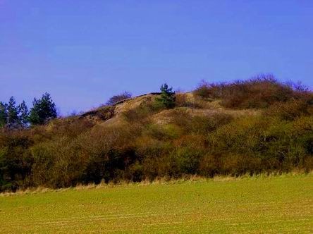
Spicak je vyhasla sopka s jasne zretelnym kraterem, ve kterem je jeste dnes mozno naleznout zvetrale cedicove kulicky.
Geologie regionu Stetsko
Oblast regionu patri k ceske kridove panvi a je budovana prevazne druhohornimi morskymi usazeninami. Tvori je vyzdvizena staroprvohorni kra slozena z chloritickych fylitu, kremenneho keratofyru a zelenych bridlic. Tretihorni vyvreliny se vyskytuji jako zilna telesa nebo jako vyplne sopouchu pronikajici casto kridovymi sedimenty. Tvori je prevazne cedicove a znelcove horniny. Ze starsiho obdobi ctvrtohor se uplatnuji predevsim pokryvy a naveje sprasi a sprasovych hlin. Mladoctvrtohorni naplavy zaujimaji jen male plochy pri stalych vodnich tocich.
Geologicky spada velka cast regionu Stetsko pod horopisny celek Ralska pahorkatina s podcelkem Dokeska pahorkatina. Nejrozsahlejsim a ustrednim okrskem Dokeske pahorkatiny jsou Polomene hory, ktere patri mezi typicke piskovcove pahorkatiny. Ve sve zapadni casti prechazeji Polomene hory pres udoli Obrtky a Brocenskou pahorkatinou do jednotvarnejsi Ustecke pahorkatiny, ktera vyplnuje jihozapad popisovane oblasti. Polomene hory jsou vymezeny zhruba linii Libechov, Mseno, Doksy, Holany, Ustek, Chcebuz. Deli se na 7 geologicky odlisnych casti, z nichz nejvetsi je na jihu lezici Kokorinska vrchovina s nejvyssim vrcholem Nedvezi (456 m) a k ni ze severu prilehajici Zdarska a Dubska vrchovina. Polomene hory predstavuji typickou piskovcovou pahorkatinu az vrchovinu s mnoha geomorfologickymi zajimavostmi.
Krajina regionu Stetsko
Z urodneho polabskeho udoli plynule prechazi do zvlnene Dokeske pahorkatiny se smisenymi lesy a zelenymi uvaly. Geologicky patri cele uzemi do křídového utvaru druhohor a puda je hlinito-jilovita. Prumerna vyska krajiny se pohybuje okolo 320 m.n.m. pricemz nejvyšší vyska je u Strachal 353 m.n.m.
Pristup ke krateru
Zaparkovat muzete na doporucenem parkovisti PA, nebo kdekoliv ve vsi a vydatete se po naucne stezce loupeznika Stetky az k pristupovemu bodu TR a odtud vyjdete na vrchol. Polovina cesty vede pres louku tak pocitejte s vetsi travou.
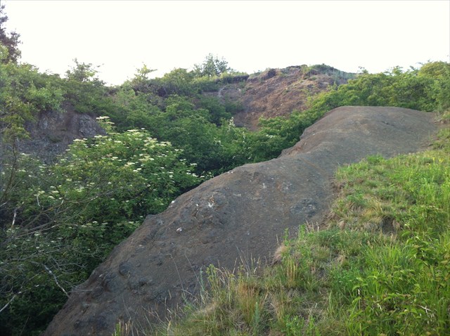
Doporucuji nesestupovat na dno krateru, ale obejit ho po jeho obvodu po pesince, lavove cedicove kulicky lze nejlepe najit na vnitrim okraji nejhladsi casti asi uprostred krateru (viz. foto 2.) nevstupujte na okraj krateru a neodlamujte kulicky.
Vasim ukolem bude zjistit a pres profil odeslat odpovedi:
1. Odhadnete hloubku krateru (m) od vrcholu.
2. Jak velke jsou cedicove kulicky (cm) ktere se daji najit na povrchu krateru. (viz obr. 2 a Ref. Point 2)
3. Jaky nejznamejsi zkamenely zivocich se v dobe rucni tezby opuky dal nalezt v tomto regionu.
4. Dobrovolny ukol – k logu prilozte fotografii vas nebo vasi GPS s kraterem v pozadi (nefotte se prosim u infocedule)
Po odeslani odpovedi necekejte na potvrzeni spravnosti a automaticky si tuto earthcache zalogujte. V pripade, ze nektera z odpovei nebude spravna, Vas budu kontaktovat.
Informace jsem cerpal z infotabule na vychozich souradnicich.
EN
Spicak basalt hill (281 m)
Spicak is an extinct volcano with a clearly visible crater in which it is still possible to find an weathered basalt balls.
Geology of the region Stetsko
Area of the region belongs to the Bohemian Cretaceous Basin, and is constructed mainly Mesozoic sea sediments. It consists of lifted the Early Palaeozoic floe composed of chloritic phyllites, quartz keratophyr and green shale. Tertiary igneous are occur as venous elements or as fill flue penetrated Cretaceous sediments. Are composed primarily of basalt and phonolite rock. From earlier period Quaternary is used mainly cover and loessdrift and loessloamdrift.The early Quaternary sediments occupy only a small area at constant streams.
A big part of the region Stetsko geologically falls under orography entirety Ralsko Uplands being hemmed Doksy Upland Hills. The largest and the central precinct Doksy upland are Polomene mountains, one of the typical sandstone uplands. At its western parts of Polomene mountains pass over valley Obrtky and Brocenska upland to the duller Ustecka upland that fills the southwest of this area. Polomene mountains are roughly defined of line Libechov, Mseno, Doksy, Holany, Ustek, Chcebuz. It is divided into seven geologically different parts of which the largest is located in the south Kokorinsko highlands with the highest peak Nedvezi (456 m) and north of it adjacent Zdarska and Dubska uplands. Polomene mountains are a typical sandstone upland and highlands with many geomorphological interest.
Landscape of the region Stetsko
From the fertile of the Elbe Valley pass continuously into the wavy Doksy upland with mixed forest and green valley. Whole territory geologically belongs to the Cretaceous formations of Mesozoic and soil is loamy-clay. The average height of the landscape is moving about 320 meters, the highest elevation is near Strachaly - 353 meters above sea level.
Access to the crater
You can park on a recommendation parking - PA, or anywhere in the village and explore the nature trail of bandit Stetka up to an access point - TR and then you go to the top. Half way leading across the meadow, count with greater grass.
I recommend not to descend to the bottom of the crater, but walk it around on footpath. Basalt lava balls are best found on the internal border of smoothest part about the middle of the crater (see photo 2). Do not enter the crater rim and do not break balls off.
Your task will be to identify and send a reply via profile:
1. Can you guess the crater depth (m) from the top.
2. How big are the basalt balls (cm) that can be found on the surface of the crater? (see picture 2 and Ref Point 2)
3. What most famous fossilized creature could be found in slate manual mining time in this region?
4. Optional tasks - insert to log a picture of you or your GPS with a crater in the background (please do not take a photo with infobar).
After submitting your answers do not wait for confirmation of the correctness and automatically login this earthcache. In the event that any of your answer is not correct, I will contact you.
The information I gathered from infobar at start coordinates.