Découverte de Callac (Kallag) par le recueil d'indices dans le Bourg
Discovery Callac (Kallag) by collecting clues in Bourg
Vous cheminez ensuite dans Callac à pied les long des étapes. You walk in the Callac walk through the steps.
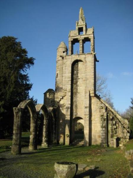
Etape 1: Le château a été construit au Moyen Âge, au cours du XII e siècle, par les comtes du Poher. C’était une forteresse, qui était bâtie sur une colline et entourée de remparts et de douves. Le château a été très endommagé et en très mauvais état, il a été rasé en 1619 par ordre du roi.Aujourd’hui, il ne reste que des ruines des remparts que l’on peut voir près de la venelle du château.
Question 1: Comment dit on les grands fossés en breton ? Les Tremeurs = 2 Les Ploemeurs = 5 Les Cleumeurs = 7 La réponse donne le C des coordonnées finales Etape 2: La maison de l'épagneul Breton. Callac est la patrie mère de cette race de chien.
Question 2: quel est le numéro inscrit sur la maison? Additionnez les deux chiffres et vous obtenez le B des coordonnées finales.
Etape 3: Hommage aux hommes tombés pendant les guerres mondiales.
Question 3: vous trouverez le A des coordonnées finales en comptant le nombre de colonnes (où sont inscrits les noms des disparus), autour du monument.
Etape 4: Le pont à bascule; Les ponts-bascules sont utilisés pour peser des camions de marchandises souvent en vrac
Question 4: Vous trouverez le chiffre D en gardant la dizaine du poids maximal du camion pouvant être pesé.
Les coordonnées finales sont N 48 A (A*2). C (A+D-C) (A*2+D) - 3 W003 A D. D ((4*B)-A) + 72 English:
Stage 1: The castle was built during the Middle Ages, during the XII century by the Counts of Poher. It was a fortress, which was built on a hill and surrounded by ramparts and moats. The castle was badly damaged and in very bad condition, it was razed in 1619 by order of roi.Aujourd Today, it remains only remains of the wall that you can see the alley near the castle. Question 1: How is the Great Divides said in Breton? The Tremeurs = 2 The Ploemeurs = 5 The Cleumeurs = 7 The answer gives the final coordinates of C
Stage 2: The house of Breton spaniel. Callac is the motherland of this breed of dog.
Question 2: What is the number on the house? Add the two together and you get the final coordinates of B.
Stage 3: Tribute to the men who fell during the world wars. Question 3: You will find the final coordinates of A by counting the number of columns (which are inscribed the names of the missing), around the monument.
Stage 4: The weighbridge; The scales used for weighing freight trucks often loose Question 4: You will find the number D by keeping the ten of the maximum weight the truck can be weighed. The final coordinates are N 48 A (A*2). C (A+D-C) (A*2+D) - 3 W003 A D. D ((4*B)-A) + 72
