A
Earthcache
No texto abaixo, assim como no local das coordenadas, poderá obter as informações necessárias para responder às seguintes questões. Estas devem ser respondidas para o meu
email de modo a poder fazer o registo como encontrada. Se tal não for feito o registo será apagado sem qualquer tipo de aviso. Não necessita de esperar pela minha autorização para efectuar o registo. Se existir algum problema será contactado(a) de modo a resolvê-lo.
- Em termos geológicos, como se chama o bloco de terreno onde se encontra?
- Está no bloco lateral Este ou Oeste do graben?
- Qual a diferença de altitude entre o local que se encontra e o vale lá em baixo (pode medir as duas altitudes)?
- Qual é a altura do muro que suporta a zona de lazer, no local em que se encontra?

The Earthcache
In the text below, as well in the place pointed by the coordinates, one can find the necessary information to answer the following questions. These should be sent to my email in order to make a found log. Failing to do this will result in the deletion of your log without notice. You don't need to wait for permission to log. If there is a problem you will be contacted to resolve it.
- In geology terms, how do you call the block of land where you stand?
- You are in the East or West side block of the graben?
- What is the difference of altitude between the place where you stand and the valley down below (you can measure both altitudes)?
- What is the height of the wall that supports the leisure area, where you stand?
Graben de Longroiva
O
graben de Longroiva é uma depressão tectónica formada com o desnivelamento dos blocos laterais e abatimento do bloco central de uma fracturação paralela numa faixa de 0,5 a 1 km de largura na Falha da Vilariça. O bloco Oeste desenvolve-se em patamares desde a Ribeira da Centieira, que corta o vale, a altitudes da ordem de 300m, até à região de Mêda, a altitudes de 650 a 750 m. O bloco Este forma uma escarpa de falha de 150 a 200 metros de altura.
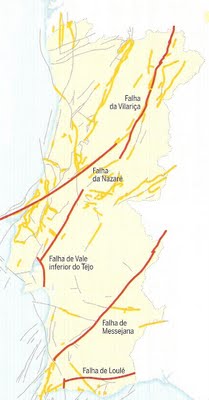
A Falha da Vilariça é uma estrutura geológica, de direcção global NE-SW, constituída por uma falha activa, que se desenvolve desde a Serra da Estrela (Unhais da Serra, Manteigas) a sul, passando pelo local das Quintâs, geologicamente conhecido por
graben de Longroiva, e evolui até à Vilariça, já a norte do Rio Douro, com continuidade mais para norte, para Espanha. A Falha da Vilariça corresponde a um desligamento esquerdo com cerca de 5,5 km de rejeito, sendo o resultado de um acidente complexo.
O
graben de Longroiva é o prolongamento para Sul do
graben da Vilariça.
Graben
Graben é a designação dada em geologia a uma depressão de origem tectónica, geralmente com a forma de um vale alongado com fundo plano, formado quando ocorre o abatimento de um bloco em relação ao terreno circundante em resultado dos movimentos combinados de falhas geológicas paralelas ou quase paralelas.
A formação de um
graben resulta do abatimento relativo de um bloco, formando uma estrutura que se distingue dos vales de origem erosiva pela presença de escarpas de falha em ambos os lados da zona em depressão. Dada a sua origem tectónica, os
graben estão frequentemente associados a estruturas complexas onde se alternam as zonas em depressão (os
graben) e as zonas elevadas (os
horst), em faixas com relativo paralelismo.
A palavra "
graben" é de origem alemã, e significa escavação ou vala.
Longroiva
Graben
The Longroiva
graben is a tectonic depression resulting from the upthrown of the side blocks and the downthrown of the central block of a parallel fracturing in a width strip of 0.5 to 1 km in the Vilariça fault. The West block grows in levels from the Centieira Stream, that flows in the valley, to altitudes of 300m, to the region of Mêda, with altitudes of 650 to 700m. The East block is a fault scarp of 150 to 200 meters high.
The Vilariça fault is a geologic structure, with a global direction NE-SW, made of an active fault, that progresses from Serra da Estrela (Unhais da Serra, Manteigas) in the south, passing by the Quintãs, geologically known as Longroiva
graben, and evolve till Vilariça, in the North of Douro river, and continues further North, to Spain. The Vilariça fault corresponds to a slip with left-lateral motion with an offset of about 5.5km, being a result of a complex phenomenon.
The Longroiva
graben is the south extension of the Vilariça
graben.
Graben
In geology, a
graben is a depression of tectonic origin, usually with a form of a flat and elongated valley created when a block of land is downthrown relatively of the surrounding terrain as a result of combined movements of parallel, or almost parallel, geologic faults.
The formation of a
graben results from a downthrown of a block of land, forming a structure that is distinct from the valleys of erosive origin by the presence of a fault scarp on each side of the depressed area. Due to its tectonic origin, the
graben are usually associated to complex structures where depressed (
graben) and elevated (
horst) zones alternate in strips of relative parallelism.
"
Graben" is the German word for ditch or trench.