Introduction
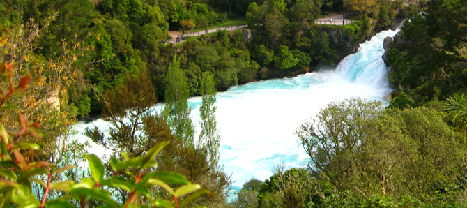
The Huka Falls are located on the Waikato River, New Zealand's longest river at 425 km in length, which runs from its headwaters at Lake Taupo to the sea just south of Auckland.
The energy in the flow of the Waikato River is harnessed by eight hydroelectrical power stations along it's path, and also used by two geothermal and one thermal powerstation, in total producing 15% of New Zealand's electricity. It is one of New Zealand's major electricity-producing rivers, and all the water that is used to produce that electricity is flowing over the waterfall in front of you at this spot.
Historically, Maori canoes were the first to navigate the river, but they normally steered clear of the falls. One chief nearly died trying to navigate the falls.
The flow over the Huka Falls is so strong that it prevents the migration of trout, or eels and other native fish. This is the reason that there are no eels in Lake Taupo or its tributaries.
All tasks to be completed can be done so from the paths through the area. Do not leave the paths or cross any railings. Answers for all questions can be found on information boards alongside the formed paths. Any attempts based on internet research will be detected and rejected - you MUST physically visit the location in order to complete the tasks and log this earthcache.
Geology
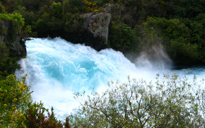
At the Huka Falls, the Waikato River is constrained from a width of approximately, 100m shortly upstream, down to a thin channel before plunging over the falls where the river widens once again. This change in topology of the river at this point is significant as it is the point where the river descends to meet a layer of rock known as the Huka Falls Formation.
The Huka Falls Formation is a geologically altered and hardened rock layer, of lacustrine shales, which caps much of the geothermal activity in the area. It was formed from mid-Pleistocene sediments laid down on the floor of a lake that covered the area well before the Oruanui eruption of Lake Taupo 26,500 years ago, and that have been geothermally altered, hardened and set like a natural concrete.
Before the river valley had deepened to the point where it reached the much harder 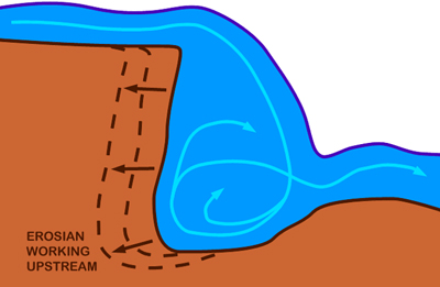 Huka Falls Formation rock layer, the river was much wider at this point, and the roughly flat areas either side of the channel would have once been the riverbed. The river then began to exploit weaknesses and fissures in the hard rock, ultimately carving out the deep channel that we see today above the falls.
The falls are currently slowly moving upstream by an erosive process whereby the power of the falls themselves chip away the edge, and the swirling action under the surface undercuts the cliff face behind the falls. Eventually the falls will move upstream past even where the pedestrian access bridge crosses the channel - just not in our lifetime.
This Earthcache
To claim a find on this earthcache, please complete the tasks outlined below. Answers to the questions should be emailed to the cache owner and not mentioned in your online log.
1. From the information boards, about how many litres of water flow over the falls and fall how many metres every second? And it's enough water every minute to fill what?
2. The icy blue colour of the water below the falls is caused by what, and how does this relate to "Huka", the Maori name of the falls, according to the information boards?
3. When standing on the pedestrian access bridge, estimate how many metres below the bridge is the churning surface of the water. If you can accurately measure it using a weight on a piece of string, even better.
4. Take a photo of the falls or the channel above the falls and include yourself, your GPS, or a personal item in the photo - upload this with your online log (do not send it to the cache owner). Who would visit Huka Falls without their camera anyway, right?!
You can log this cache straight away after you have emailed your answers to the cache owner, no need to wait for confirmation. Please include the name of this earthcache in the email - you'd be surprised how many people forget. Also, when contacting us with answers, if you want a reply, please include your email address. Don't forget to upload your photo with your online find log. Any problems with your answers we'll be in touch.
Happy Earthcaching!!!
 TGC4
TGC4