As an earthcache, there is no “box” or “container” to discover. Rather, with this cache, you discover something about the geology of the area. For more info about Earth Caches take a look at www.earthcache.org
River
A river is a natural watercourse, usually freshwater, flowing towards an ocean, a lake, a sea, or another river. In a few cases, a river simply flows into the ground or dries up completely before reaching another body of water. Small rivers may also be called by several other names, including stream, creek, brook, rivulet, tributary and rill. There are no official definitions for generic terms, such as river, as applied to geographic features, although in some countries or communities a stream may be defined by its size. Many names for small rivers are specific to geographic location; one example is "burn" in Scotland and northeast England. Sometimes a river is said to be larger than a creek, but this is not always the case, because of vagueness in the language.
Rivers are part of the hydrological cycle. Water within a river is generally collected from precipitation through a drainage basin from surface runoff and other sources such as groundwater recharge, springs, and the release of stored water in natural ice and snowpacks (e.g., from glaciers). Potamology is the scientific study of rivers.
Meander
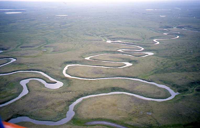
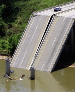
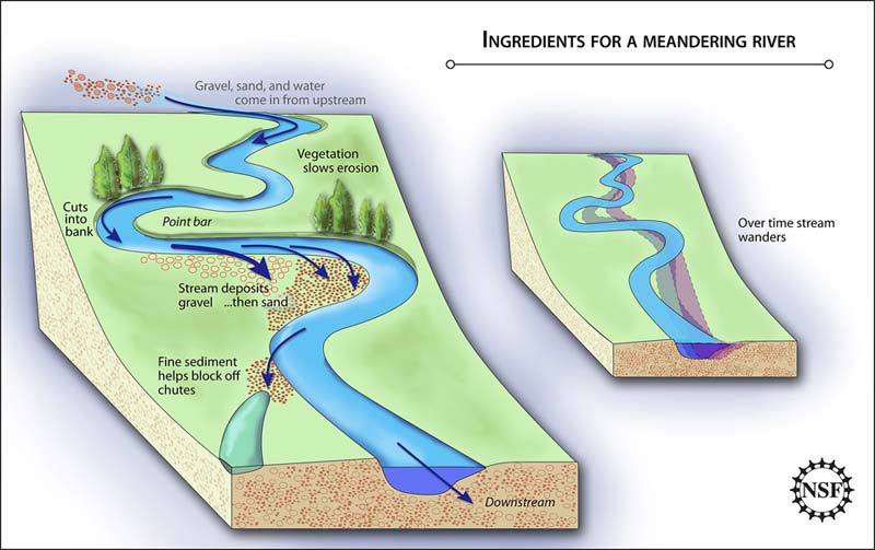
A meander, in general, is a bend in a sinuous watercourse or river. A meander is formed when the moving water in a stream erodes the outer banks and widens its valley. A stream of any volume may assume a meandering course, alternately eroding sediments from the outside of a bend and depositing them on the inside. The result is a snaking pattern as the stream meanders back and forth across its down-valley axis. When a meander gets cut off from the main stream, an oxbow lake is formed. Over time meanders migrate downstream, sometimes in such a short time as to create civil engineering problems for local municipalities attempting to maintain stable roads and bridges.
Origin
The term derives from a river located in present-day Turkey and known to the Greeks as (Μαίανδρος) Maiandros or Maeander, characterised by a very convoluted path along the lower reach. As such, even in Classical Greece (and in later Greek thought) the name of the river had become a common noun meaning anything convoluted and winding, such as decorative patterns or speech and ideas, as well as the geomorphological feature. Strabo said: "... its course is so exceedingly winding that everything winding is called meandering."
The Meander River is located south of Izmir, east of the ancient Greek town of Miletus, now, Milet, Turkey. It flows through a graben in the Menderes Massif, but has a flood plain much wider than the meander zone in its lower reach. In the Turkish name, the Büyük Menderes River, Menderes is from "Meander".
Formation
Meander formation is a result of natural factors and processes. The waveform configuration of a stream is constantly changing. Fluid flows around a bend in a vortex. Once a channel begins to follow a sinusoidal path, the amplitude and concavity of the loops increase dramatically due to the effect of helical flow sweeping dense eroded material towards the inside of the bend, and leaving the outside of the bend unprotected and therefore vulnerable to accelerated erosion, forming a positive feedback loop.
The cross-current along the floor of the channel is part of the secondary flow and sweeps dense eroded material towards the inside of the bend. The cross-current then rises to the surface near the inside and flows towards the outside, forming the helical flow. The greater the curvature of the bend, and the faster the flow, the stronger is the cross-current and the sweeping.
Due to the conservation of angular momentum the speed on the inside of the bend is faster than on the outside.
Since the flow velocity is diminished, so is the centrifugal pressure. However, the pressure of the super-elevated column prevails, developing an unbalanced gradient that moves water back across the bottom from the outside to the inside. The flow is supplied by a counter-flow across the surface from the inside to the outside. This entire situation is very similar to the Tea leaf paradox. This secondary flow carries sediment from the outside of the bend to the inside making the river more meandering.
Logging Requirements
To be able to log this Earthcache as found you need to first email the answers to the following questions to CO through the mail link in the above profile, you can then log as found. Please don't include any answers in your logs or they will be deleted.
1. Stand on the bridge at the Co-ordinates above and look downstream - Which river bank directly in front of you is showing signs of erosion and explain why?
2. From the same location observe the water flow - Is it faster on the inside or outside of the bend and explain why?
3. Look at the river bed from either side of the bridge - What signs of erosion and particle drift can be clearly seen?
4. Please post a Pic of you and your GPSR at GZ (Optional)
