CJS - Eastern Shore of VA National Wildlife Refuge Traditional Geocache
CJS - Eastern Shore of VA National Wildlife Refuge
-
Difficulty:
-

-
Terrain:
-

Size:  (regular)
Please note Use of geocaching.com services is subject to the terms and conditions
in our disclaimer.


Come on a journey to remember and commemorate the history and travels of Captain John Smith! Over four hundred years ago, Englishman John Smith and a small crew set out in an open boat to explore the Chesapeake Bay. Between 1607 and 1609 Smith mapped and documented nearly 3,000 miles of the Bay and its rivers. Along the way he visited many thriving American Indians communities and gathered information about this “fruitful and delightsome land.” In December 2006 the U.S. Congress designated the routes of Smith’s explorations of the Chesapeake as a national historic trail—the first national water trail.
Are you ready to follow in the wake of Captain John Smith? Visit sites along the National Historic Trail and learn about the native cultures and the natural environment of the 17th-century Chesapeake through the Captain John Smith Chesapeake Geotrail. The Trail provides opportunities for you to experience the Bay through the routes and places associated with Smith’s explorations. Caches will be located in museums, refuges, parks, and towns in Virginia, Maryland and Delaware along the rivers and creeks that Smith and his crew explored four centuries ago.
The Captain John Smith (CJS) Geotrail launched June 4, 2011 with over 40 caches within Maryland, Virginia and Delaware. A trackable geo coin will be awarded to the first 400 geocachers, while supplies last, for locating at least 15 CJS caches. To be eligible for the coin, geocachers must download a passport from either the CJS Geotrail or Maryland Geocaching Society website. Geocachers must find and log at least 15 finds, record the code word from each cache on their passport and post a picture of themselve at each cache location. After discovering the 15 required caches, geocachers may have thier passports validated in person or via mail at the National Park Service, Chesapeake Bay Office located at 410 Severn Ave, Suite 314, Annapolis, MD 21403. Please refer to the passport for complete validation instructions.
Participating in the CJS geotrail is fun and we hope that many people join in. However, it is not a requirement for logging your find on this cache once you find the container.
This cache was placed with special permission from the VA NWR. We ask that cachers follow all facility rules, regulations and park hours. Please NO night caching! You are seeking a traditional hide stocked with a variety of items. After you find the cache, take the time to enjoy this special park property!
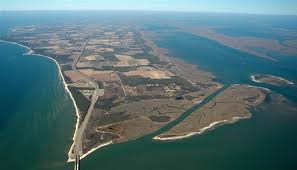
The Eastern Shore of Virginia National Wildlife Refuge (NWR) was established on 1984 and is located on the tip of the Delmarva Peninsula at the mouth of the Chesapeake Bay. The land area encompasses 1,415 acres of maritime forest, myrtle and bayberry thickets, grasslands, and fresh and brackish ponds. The NWR is managed by the U.S. Fish and Wildlife Service. An avian migration occurs each fall with a major stopover on the NWR for birds and butterflies, including hawks, falcons, songbirds, black ducks, blue herons, chickadees, great horned owls, woodpeckers, warblers and more. These aviation species wait at the NWR each fall for favorable winds and weather to make the journey across the Chesapeake Bay to continue their migration south for the winter. Fisherman Island is within the NWR lands, which is a Wetland of International Importance for its waterfowl habitat.
Captain John Smith left Jamestown in 1608 to explore the Chesapeake Bay. His stops along the Eastern Shore yielded precious little fresh water, but he left a legacy by naming an island for himself and other landmarks for men in his crew. The Eastern Shore was largely isolated from the "western shore" for generations. The geography of the Eastern Shore molded the character of its residents: it was remote, flush with fish and shellfish, and endowed with good soil for growing crops. Today, the managed landscape within the NWR still evokes a similar landscape that Captain John Smith would have seen on his exploration of the Chesapeake Bay.
Today there are many opportunities on the NWR for wildlife observation and photography, environmental education and interpretation, hunting, and boating. Wise Point boat ramp is available for the public, and there is a visitor center with a butterfly garden as well. Hikers and bikers are welcome to explore the NWR on the new southern tip bike and hike trail.

Thanks to Banshee74 for helping with this hide and to the Maryland Geocaching Society for assisting with this project!
The refuge's headquarters is located at 5003 Hallett Circle, Cape Charles, VA 23310. It is open Monday-Friday 8:00am-4:00pm. The Visitor Center is open:
January – February, Friday- Sunday 10:00 a.m. to 2:00 p.m.
April - November daily 9:00 a.m. to 4:00 p.m.
December and March daily 10:00 a.m. to 2:00 p.m.
Additional Hints
(Decrypt)
Purpx gur fvta.