 O meu VG mais arriscado, e quiças o mais bonito.
Depois de ter descoberto que o Farol de Sta. Marta era um VG não descansei enquanto não encontrei um spot para colocar uma cache. Por isso aqui fica o meu contributo para os VG de Portugal. Este VG está colocado na cupula do próprio farol (luminária) a 28,24mts de altitude. Aproveitem visitem o farol, é grátis.
Parque de estacionamento por perto.
Vértices Geodésicos:
Conjunto de todos os vértices geodésicos e das suas relações geométricas, distribuídos pelo país, colocadosem posições dominantes de forma a garantir intervisibilidade, devidamente coordenados. Estão materializados através de diversas formas geométricas, como pirâmides ou troncos de cone sobre cilindros (bolembreanas) ou são coincidentes com estruturas já existentes.
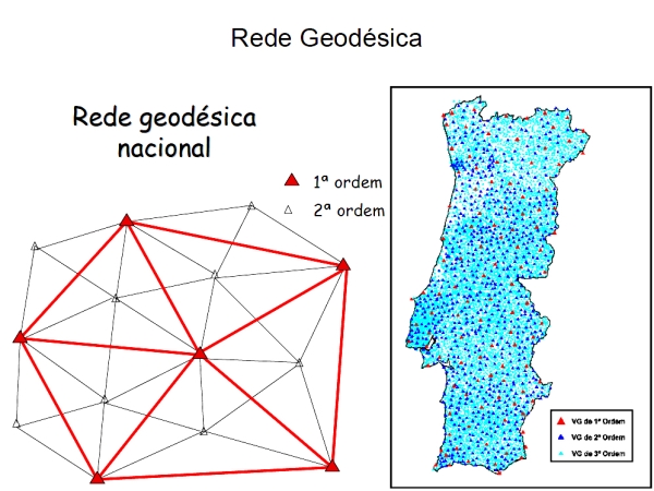
Um VG ou vértice geodésico (popularmente chamado "talefe" em Portugal, e "Pinoco" no Norte de Portugal) é um sinal que indica uma posição cartográfica exacta e que forma parte de uma rede de triângulos com outros vértices geodésicos. São escolhidos sítios altos e isolados com linha de visão para outros vértices.
A rede geodésica portuguesa é formada por vértices geodésicos que se dividem em três ordens de importância:
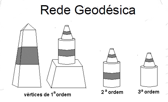
1ª Ordem - pirâmides distando 30 a 60 km
2ª Ordem - cilindro + cone listados distando 20 a 30 km
3ª Ordem - cilindro + cone distando 5 a 10 km
O número de vértices existentes na totalidade do território (Portugal Continental e Regiões Autónomas) é, actualmente, de cerca de nove mil, repartidos por vértices de: Continente: 1ª Ordem (cerca de 120), 2ª Ordem (cerca de 900) e 3ª Ordem (com uma densidade aproximada de 1 vértice por cada 10 km²) Arquipélago dos Açores: cerca de 500 Arquipélago da Madeira: cerca de 150 A RGN é a infra-estrutura básica onde se apoia toda a cartografia do País, e que serve todos aqueles (empresas, autarquias e outros organismos públicos e privados) que, por força das suas actividades, necessitam de referenciar geograficamente os seus projectos (os Planos Directores Municipais, por exemplo).
O Centro Geodésico de Portugal, está situado na Serra da Melriça, freguesia e concelho de Vila de Rei, distrito de Castelo Branco.
Encontrando-se a uma Altitude máxima ao Nível do Mar de 592m (anm/asl) é delineado fundamentalmente pelo Marco Geodésico padrão, pelo Museu da Geodesia e áreas envolvente de apoio e estacionamento.
O Marco Geodésico, é conhecido popularmente por "Picoto da Melriça", sendo constituído por um vértice geodésico de 1ª ordem, piramidal, em alvenaria com 3 metros de base e 9 metros de altura e está desde á muito associado à história da cartografia moderna em Portugal. Esta iniciou-se no século XVIII, no reinado de D. Maria I, quando a soberana convidou a Academia Real da Marinha, a iniciar os trabalhos de triangulação geral do território, para a realização da Carta Geográfica do Reino.
A importância do Marco Geodésico padrão, resulta de que foi a partir deste ponto, que se deu início à marcação dos restantes 8.000 vértices geodésicos de Portugal Continental.
As coordenadas do Marco Geodésico são: latitude: N39º 41´ 40,14" longitude: W8º 07´ 49,80" que corresponde ao Maidenhead Locator IM59wq. Nele pode-se encontrar a geocache (GC1E4NM) integrada nas caches Lusitani.
A CACHE:
A cache é uma embalagem não tradicional de plástico. Contem logbook e stashnote. Deixem como encontraram. Não é preciso inventar. O sitio onde esta a cache NÃO É FÁCIL e as coordenadas podem dar ao lado, atentem por favor na foto spoiler.
Se não se sentirem confiantes NÃO ARRISQUEM! Não façam a cache!
Sempre que possivel façam C.I.T.O. ("cache in trash out" que é como quem diz "faz a cache recolhe lixo") e divirtam-se.
Podem consultar spoiler: aqui.
Espero que gostem.

Maybe my prettiest and riskier VG. After having discovered that the Lighthouse of Sta. Marta was a VG I did not rest while I did not find one spot to place one cache. Therefore my contribute for the VG of Portugal.
This VG is placed in the cupola of the proper lighthouse (lights) 28,24mts of altitude.
It's free to enter and visit the lighthouse. There is free and charging parking nearby.
Geodesic vertices:
Set of all the geodesic vertices and its geometric relations, distributed in the country, placed in dominant form positions to guarantee intervisibilidade, duly coordinate. They are materialized through diverse geometric forms: as pyramids or trunks of cone on cylinders (bolembreanas) or are coincident with already existing structures (curches, lighthouses monuments etc etc.)
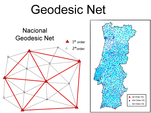
A VG or geodesic vertex (popularly called " talefe" in Portugal, and " Pinoco" in the North of Portugal) it is a signal that indicates a cartographic position exacta and that it forms part of a net of triangles with other geodesic vertices. High and isolated small places with line of vision for other vertices are chosen. The Portuguese geodesic net is formed by geodesic vertices that are divide in three orders of importance:
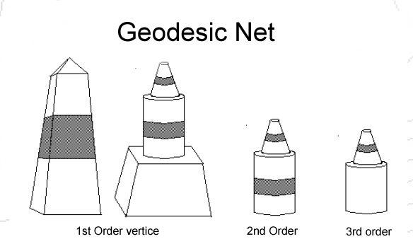
1ª Order - pyramids apart betwenn 30 km and 60km
2ª Order - cylinder + cone apart 20 to 30 km
3ª Order - cylinder + cone apart 5 to 10 km
The number of existing vertices in the totality of the territory (Continental Portugal and Autonomous Regions) is, currently, of about nine a thousand, distributed for vertices of: Continent: 1ª Order (about 120), 2ª Order (about 900) and 3ª Order (with an approach density of 1 vertex for each 10 km ²) Archipelago of the Açores: about 500 Archipelago of Madeira: about 150 the RGN is the basic infrastructure where if the cartography of the Country supports all, and that it serves all those (public and private companies, autarchies and other organisms) that, for force of its activities, they need to mention its geographically projects (the Municipal Director Plan, for example).
The Geodesic Center of Portugal, is located in the "Serra da Melriça" (Melriça Mountain), coucil of Vila de Rei, Castello Branco's district. Meeting it a maximum Altitude to the Level of the Sea of 592m (anm/asl) standard is delineated basically by the Geodesic Landmark, for the Museum Geodesy (located there) and areas of support and parking. The Geodesic Landmark, is known popularly by " Picoto of the Melriça" , being constituted of a geodesic vertex of 1st order, piramidal, in masonry with 3 meters of base and 9 meters of height and it is since very the associate to the history of the modern cartography in Portugal. This was initiated in century XVIII, in the reign of D. Maria I, when the sovereign invited the Real Academy of the Navy, to initiate the works of general triangulation of the territory, for the accomplishment of the Geographic Letter of the Kingdom.
The importance of the Geodesic Landmark standard, results of that it was from this point, that if gave beginning to the marking of the remains 8,000 geodesic vertices of Continental Portugal.
The coordinates of the Geodesic Landmark are: latitude: N39º 41´ 40,14" longitude: W8º 07´ 49,80" that it corresponds to the Maidenhead Locator IM59wq. There is a geocache (GC1E4NM) integrated in caches Lusitani to be found.
THE CACHE:
Cache is a not traditional plastic packing. There you find logbook and stashnote. Please leave as you have found it. It's not necessary to invent anything. The cache place IS NOT EASY and the coordinates can give to the side, please pay the due attention to photo spoiler.
If you do not to feel confident DO NOT RISK! do not do the cache!
You can see spoiler here.
Whenever possible then make C.I.T.O. (cache in trash out), and of course, have fun.
I hope you like it.
Mais uma cache by/another cache by:

ENJOY!