Mestne vpadnice / Radial roads Mystery Cache
Mestne vpadnice / Radial roads
-
Difficulty:
-

-
Terrain:
-

Size:  (small)
Please note Use of geocaching.com services is subject to the terms and conditions
in our disclaimer.
SLO: Pri tej nalogi bo prav prišlo znanje geometrije, s pomocjo katere boste dolocili koncne koordinate še ene Ljubljanske vpadnice. Ta vpadnica je najmogocnejša in najlepša, vendar lahko zelo hitro pozabimo nanjo.
EN: In this task the knowledge of geometry will help you to determine the final coordinates of another radial road of Ljubljana. This road, which enters the capital, is the mightiest and most beautiful, but very quickly forgotten.
SLO: Pomembno je da sledite navodilom, rešujete po vrstnem redu, še najbolj pomembno pa je, da si vzamete cas in natancno narišete, kar je od vas zahtevano. Saj vam bo samo tako delo omogocilo hitro in enostavno rešitev. Seveda si lahko pomagate tudi s kakšnim programom za risanje(AutoCad).
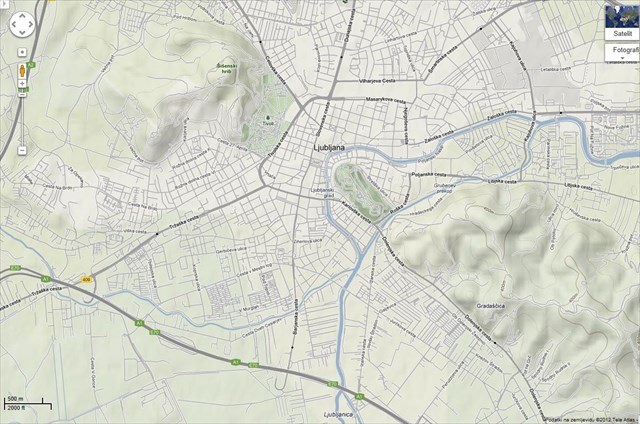
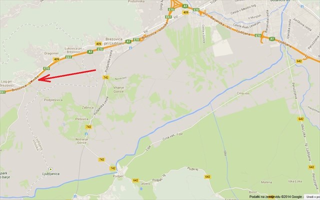
Naložite si oba zemljevida, ki sta pripeta k navodilom!

Tocka A = Tržaška cesta
Tocka B = Barjanska cesta
Tocka C = Dolenjska cesta
Tocka D = Zaloška cesta
Tocka E = Šmartinska cesta
Tocka F = Dunajska cesta
Tocka G = Celovška cesta
----------------------------------
Tocka H = Log pri Brezovici (že vrisana)
Tocka I = dobljena na sliki 1
Tocka J = končna točka
Vaše naloge:
1. slika:
• Na vsaki Ljubljanski cestni vpadnici je postavljena tocka, katere je potrebno povezati v mnogokotnik (7 tock).
• Razdeli kot DEF na polovico in potegni premico do daljice BC.
• Naredi 2 simetrali daljic: AB in EF. Dobiš tocko na vsaki omenjeni daljici.
• Poveži vse tri novonastale tocke v trikotnik (dobite klin)
• Klinu ocrtajte krog
• Dolocanje ozkega podrocja (manjši trikotnik):
1) Potegni navpicnico skozi krožnico cez središce krožnice
2) Od tocke B potegni premico cez sredino daljice CD
3) Zadnjo mejo podrocja doloca že zarisana daljica: spodnja stranica klina
• Dobiš majhen trikotnik v katerem doloci težišce
• Težišce doloca prvo točko na mestni vpadnici - točko I
• Določi mestno vpadnico
2. slika:

• Poiskusi prerisati točko I iz slike 1 na sliko 2 čim bolj natančno
• Zapiči šestilo v točko I do točke H (glej kam kaže puščica) in naredi lok tako, da dobiš še drugo točko J na mestni vpadnici
• Dobil si lokacijo zaklada!
BONUS TOCKE: Za simetralo kota in daljic ne potrebuješ kotomera ali merila, vse lahko narediš z šestilom! Znaš kako?
Kontaktiraj me prosim, ce imaš težave zaradi majhne slike. Bom poslal original! Drugace lahko sliko povecaš v Wordu.
EN: It is important to follow instructions, working in the subscribed order, but the most important is that you take the time to carefully draw what is required of you. Only working in this way will provide you fast and easy solution. Of course you can also help youself with one of the drawing programs (AutoCad).
Download both maps, that are attached to the instructions!

Point A = Trzaska road
Point B = Barjanska road
Point C = Dolenjska road
Point D = Zaloška road
Point E = Šmartinska road
Point F = Dunajska road
Point G = Celovška road
----------------------------------
Point H = Log pri Brezovici (allready inserted)
Point I = result given from picture 1
Point J = end point
Your tasks:
1. picture:
• Points are set at each Ljubljana radial road, which are necessary to connect to make a polygon (7 points).
• Divide angle DEF in half and pull the line to line segment BC.
• Make 2 symmetry line segments: AB and EF. You get the point mentioned in each segment.
• Connect all three newly created points in a triangle
• inscribe the triangle with circle through the points
• Determination of the narrow area of Point I (smaller triangle):
1) Pull the vertical line through the circle through the center of the circle
2) From point B, pull the line across the middle line segment CD
3) The final frontier is already defined by the lower segment of the triangle.
• You get a small triangle in which you must define balance point
• The balance point provides the first point on radial road
• Define or name the radial road
2. picture:

• Copy point I from picture 1 to picture 2 as carefull as possible
• Use a pair of compasses again: use point I and draw an arc from point H (arrow is pointing on it) to radial road to get another point J on it
• You got the location of cache
BONUS POINTS: For making halfs of angles and line segments you do not need a angle measurer or ruller. All you need for those tasks is pair of compasses! You know how to do it?
If you have difficulties with the small image, please contact me and i will send you original. Otherwise you can adjust image size in Word.
--------------------------------------------------------------------------------------------------------------
You can check your answers for this puzzle on GeoChecker.com.
--------------------------------------------------------------------------------------------------------------

Additional Hints
(Decrypt)
Mtbenw / Nobir
n = 38°