 English
Tenerife: Geological Background
Tenerife looks back onto a long and varied history of volcanism. Unlike other volcanoes, the island is not situated on a tectonic plate boundary but on a hot spot right on the African Plate. The very hot material under the hot spot melts its way through the Lithosphere and builds volcanoes on the surface.
7-9 million years ago, Tenerife's position was occupied by three islands consisting of shield volcanoes. Their remains today are the massifs of Teno (in the northwest), Adeje (in the southwest) and Anaga (in the east). 3 million years ago the volcanism had shifted and created a high ridge (the Cordillera Dorsal) southwest of the Anaga massif, connecting the three islands. Later, a new, big volcano called "Las Cañadas" appeared close to the Adeje massif. It may have had 40km in diameter and 4.500 m in height, and it collapsed several times. The last of these collapses occured 170 thousand years ago, the mountain either falling vertically into an empty magma chamber or sliding into the sea in giant gravitational landslides. That was when the caldera Las Cañadas appeared, a kettle-like crater in the centre of Tenerife, 12-17 km in diameter. Today, this is also where Mount Teide rises 3,718 metres high.
Tenerife's valleys, like La Orotava and Güímar, are reaching down to the sea and were created by landslides down the Cordillera Dorsal and other ranges. The Earthcache's position is on the coastline of the Valle de La Orotava.
Erosion
Where volcanism is adding material, erosion takes it away again. Types of erosion are:
- fluvial erosion - e.g. rivers cutting their own valleys;
- glacial erosion - by glaciers;
- aeolian erosion - wind blowing away sand and dust;
- marine erosion - caused by surf and breakers.
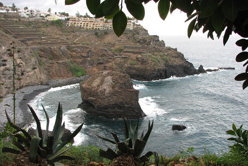
Playa de los Roques
On the Playa de los Roques you can see several types of erosion. Different kinds of rock material have been brought to the coast by landslides; they vary in hardness, and thus in the speed they are being eaten away.
- Between Punta Pejes Reyes and Punta Piedra Gorda, the surf has created a bay by eating material out of the coastline (marine erosion). Not only the water itself is at work here. Stones moved by the surf act on the shoreline like a chisel.
- From higher up, material slides down into the sea, as the shoreline is hollowed out. Wind and rain play a part here, too (aeolian and fluvial erosion). Small stones and sticks often fall down on the beach, so better be a little careful when you walk the beach.
- In front of the slope, rocks have accumulated to form a beach, protecting the slope from most of the surf. The strength and the direction of the wind decide if the surf can reach the slope at all. Another factor are the tides, obviously, since the tide range on Tenerife is between one and two metres (cf. http://tides.mobilegeographics.com/locations/5612.html).
- Standing on the beach, you can hear a sound like gravel being dumped from a truck, which is exactly what it is. The surf lifts up the heavy rocks and beats them against each other.
- Finally, most spectacular to look at, there are the two large boulders in the bay. The minerals they consist of differ in hardness. The surf has eroded away the softer parts, leaving the harder material to form the pillars of natural arches.
Logging Requirements:
To log this Earthcache as found, you must have visited the place, and you must have answered the questions below. A sign at WP "VIEWE - View from the East" will help you answer question 2a). The answer to question 2b) can be observed from the vicinity of WP "VIEWW - View from the West".
1) How for up the beach does the surf get? Does it reach the slope? Make a sketch or take a photo of the beach as seen from WP "VIEWE - View from the East" and measure (or estimate) how wide the dry stretch of beach is (if any). Please add date and time and the approximate wind direction and strength.
2a) Sign "El Burgado": Pigeon, kestrels and yellow-legged gulls all make up this "??? ???".
2b) How many pillars does the large, western boulder rest on? (including the very thick main pillar to the east)?
2c) In your own words, briefly describe why the stones on this beach (and pebbles everywhere) are rounded.
Please add your solutions of task no. 1) to your log on geocaching.com.
Please do NOT put the answers of tasks no. 2a/b/c) into the log, but send me a personal e-mail containing the answers. You do not have to wait for my confirmation to log the earthcache; if something is wrong, I'll get in touch with you.
* * * * *
 Español
La geología de Tenerife
La historia de Tenerife es largo, emocionante y volcánicas. A diferencia de otros volcanes, la isla no ha sido - y no es - en la costura entre dos placas lithosphärias, en lugar de una llamada “Hotspot“ en el centro de la placa africana.
Antes de 7-9 milliones de años estan, en lo que hoy es Tenerife, tres “Escudo-del-volcán-islas“, sus restos hoy representar la enorme montaña Teno (en el noroeste), Adeje (en el suroeste) y Anaga (en el este). Antes 3 milliones de años la actividad volcánica se había desplazado un poco, crea ahora por primera vez al sudoeste de la masiva Anaga un cresta alto (la cordillera dorsal), lo que unido las tres islas. Luego vino cerrar de la masiva Adeje una muy grande, nuevo volcán. Este volcán llamada “Las Cañadas“ podría tener un diámetro de hasta 40 kilómetro y un alto de 4.500 metro y se derrumbó en varias ocasiones. Alrededor de 170.000 años se rompió la última vez, cualquiera verticalmente en un blanco cámara magmática, o bien – probablemente es más probable – deslizarse através de un lado de las laderas de las montañas. Esto resultó en la Caldera Las Cañadas con un diámetro de 12-17 km y un cráter parece una caldera que representa el media de Tenerife. A partir de este cráter hoy se levanta entre otros el Pico del Teide en 3.718 m de altitud.
Los valles de Tenerife llegan hasta el mar. El valle de la Orotava y el valle de Güímar, por ejemplo, causada por el deslizamiento de la roca - a partir de la Cordillera Dorsal. El geocaché se encuentra en la costa del valle de la Orotava.
Erosion
Dondé los materiales de origen volcánico añadido, como la erosión que se quitar de nuevo. La erosión es el proceso de extracción de roca. Despendiendo de la fuerza que actúa, se establece una distinción entre otras cosas:
- La erosión fluvial – por el agua que fluye; así, por ejemplo la formación de los valles de los ríos
- La erosión glazial – por los glaciares
- La erosión eólico – por el viento, lo que soplando el polvo y la arena
- La erosión marina – por el efecto de las olas
Playa de los Roques
En Playa de Los Roques se pueden observar diferentes tipos de erosión. Los deslizamientos de tierra han traído diferentes duras rocas de la costa, que se eliminan en diversos grados.
- La bahía entre los dos cabos Punta Pejes Reyes y Piedra Gorda se ha lavado de las olas (erosión marina). El agua disuelve el material de la línea de costa y ahuecado hacia fuera. No tanto de la propia agua juega un papel, sino también las piedras llevadas por las olas: El agua puede ser el martillo, el cincel son las piedras.
- Socavada por la fuerte pendiente de deslizamiento de material adicional y aumenta el efecto. Aquí también juegan un papel del viento y la lluvia (erosión eólico y erosión fluvial). Casi siempre hay asteriscos pequeños y partes de plantas de la parte superior de la playa; algo así que ten cuidado.
- Contra el acantilado de una playa fue creado a partir de los cálculos de la protección de taludes contra la erosión son ahora parcialmente. Ya sea que el oleaje llega a la inclinación depende de la intensidad y dirección del viento, y también por las mareas.El rango de mareas es de al menos 1-2 metros (ver. http://tides.mobilegeographics.com/locations/5612.html)
- Si usted está parado en la playa, entonces se puede oír un ruido, como un camión de grava descargando: es sólo que. Las libras de surf a menudo levanta las pesadas piedras y golpear juntos.
- La vista más espectacular de las dos rocas que se encuentran en la bahía, y que consisten en varias rocas duras. El surf se ha desgastado las partes más blandas y salió de las dificuktades; creó las puertas de surf llamados.
Las tareas
Tener que registrar este caché de la tierra, debe estar en el sitio y se han completado las tareas. En el punto de referencia „VIEWE – View from the East“ es un panel de información en la que se pida la respuesta a la 2a. La respuesta a la pregunta 2b se puede ver en las proximidades del punto de referencia „VIEWW – View from the West“.
1) Qué tan cerca viene el agua a las pistas? Una vez que alcanza la pendiente? Dibujo o fotografía a la playa desde el punto de referencia „VIEWE – View from the East“ y la medida o estimación de la anchura de la franja seca de playa, entre el oleaje y la pendiente es. Por favor, llamar a esta fecha y la hora, la dirección del viento y si el viento es más fuerte o débil.
2a) Panel informativo "El Burgado": Palomas, cernicalos y gaviotas patiamarillas forman un "??? ???".
2b) Cómo muchos pilares descansa la roca del oeste grande (incluyendo el muelle este de muy grueso principal?
2c) Describa brevemente con tus propias palabras por qué las piedras y guijarros en la playa, aquí están redondeadas.
Colgar la solución 1 a su registro en la geocaching.com.
Envíe sus respuestas a la 2a a 2c en mi perfil; estas soluciones no escribir en el registro! Usted no necesita esperar a que el registro de aprobación; si algo no está bien, firmo.
(Danke an K.S. für die Übersetzung!)
* * * * *
 Deutsch
Die Geologie von Teneriffa
Teneriffas geologische Geschichte ist lang, bewegt und vulkanisch. Anders als andere Vulkane lag - und liegt - die Insel nicht auf der Naht zwischen zwei Lithoshärenplatten, sondern über einem sogenannten Hotspot mitten auf der Afrikanischen Platte. Das flüssige Gestein unter einem Hotspot ist besonders heiß und daher in der Lage, sich Wege durch den Erdmantel zu schmelzen und an der Oberfläche Vulkane zu erzeugen.
Vor 7-9 Mio. Jahren entstanden dort, wo heute Teneriffa ist, drei Schildvulkan-Inseln, deren Überreste heute die Gebirgsmassive Teno (im Nordwesten), Adeje (im Südwesten) und Anaga (im Osten) bilden. Vor 3 Mio. Jahren hatte sich der Vulkanismus etwas verschoben schuf nun südwestlich des Anaga-Massivs zuerst einen hohen Gebirgsrücken (die Cordillera Dorsal), der die drei Inseln vereinte. Später entstand in der Nähe des Adeje-Massivs ein sehr großer, neuer Vulkan. Dieser "Las Cañadas" genannte Vukan könnte bis zu 40 km Durchmesser und 4.500 m Höhe gehabt haben und stürzte mehrfach ein. Vor rund 170.000 Jahren brach der Vulkan letztmalig zusammen, entweder vertikal in eine leere Magmakammer, oder - wohl wahrscheinlicher - durch seitliches Abrutschen der Berghänge. Dabei entstand die Caldera Las Cañadas, ein 12-17 km durchmessender, kesselartiger Krater in der Mitte Teneriffas. Aus diesem Krater erhebt sich heute u.a. der Pico del Teide mit 3.718 m Höhe.
Die bis ans Meer reichenden Täler von Teneriffa, z.B. das Valle de La Orotava und das Valle de Güímar, entstanden durch das Abrutschen von Gestein z.B. von der Cordillera Dorsal. Der Earthcache liegt an der Küstenlinie des Valle de La Orotava.
Erosion
Wo Vulkanismus Material hinzufügt, da nimmt Erosion es wieder weg. Erosion ist der Prozess der Abtragung von Boden bzw. Gestein. Je nach wirkender Kraft unterscheidet man u.a.:
- fluviatile Erosion - durch fließendes Wasser; also z.B. die Bildung von Flusstälern;
- glaziale Erosion - durch Gletscher;
- äolische Erosion - durch Wind, der Staub und Sand fortweht; und
- marine Erosion - durch die Wirkung der Meeresbrandung.
Playa de los Roques
Am Playa de los Roques kann man verschiedene Arten der Erosion beobachten. Die Erdrutsche haben verschieden harte Gesteine an die Küste gebracht, die unterschiedlich stark abgetragen werden.
- Die Bucht zwischen den beiden Kaps Punta Pejes Reyes und Punta Piedra Gorda hat die Meeresbrandung ausgewaschen (marine Erosion). Das Wasser löst Material aus der Küstenlinie und höhlt sie aus. Dabei spielt weniger das Wasser selbst eine Rolle, sondern auch die von der Brandung mitgeführten Steine: Das Wasser mag der Hammer sein, die Steine sind der Meißel.
- Vom unterhöhlten Steilhang rutscht weiteres Material nach und verstärkt den Effekt. Hier spielen auch Wind und Niederschlag eine Rolle (äolische und fluviatile Erosion). Es fallen fast ständig kleine Steinchen und Pflanzenteile von oben auf den Strand; etwas Vorsicht ist also geboten.
- Vor dem Steilhang ist ein Strand aus Steinen entstanden, der den Hang nun teilweise vor Erosion schützt. Ob die Brandung den Hang erreicht, hängt von der Stärke und der Richtung des Windes ab, und auch von Ebbe und Flut. Der Tidenhub um Teneriffa beträgt immerhin 1-2 Meter (s. http://tides.mobilegeographics.com/locations/5612.html).
- Wenn man am Strand steht, dann kann man ein Geräusch wie von einem abkippenden Kieslaster hören: es ist genau das. Die Brandung hebt die oft kiloschweren Steine an und schlägt sie gegeneinander.
- Der spektakulärste Anblick sind die beiden großen Felsen, die in der Bucht liegen, und die aus unterschiedlich harten Gesteinen bestehen. Die Brandung hat die weicheren Teile abgetragen und die härteren stehen gelassen; es entstanden sogenannte Brandungstore.
Aufgaben
Um diesen Earthcache zu loggen, müsst ihr vor Ort gewesen sein und die Aufgeben erledigt haben. Am Wegpunkt "VIEWE - View from the East" steht eine Informationstafel, auf der ihr die Antwort zu Frage 2a) findet. Die Antwort auf Frage 2b) könnt ihr aus der Umgebung von Wegpunkt "VIEWW - View from the West" sehen.
1) Wie nah kommt das Wasser dem Hang? Erreicht es den Hang? Skizziere oder fotografiere dazu den Strand vom Wegpunkt "VIEWE - View from the East" aus und messe oder schätze dazu, wie breit der trockene Streifen des Strandes zwischen Brandung und Hang ist. Nenne dazu bitte auch Datum und Uhrzeit, die Windrichtung und ob der Wind eher stark oder schwach ist.
2a) Infotafel "El Burgado": Tauben, Turmfalken und Möwen bilden eine "??? ???".
2b) Auf wie vielen Pfeilern ruht der große, westliche Felsen (einschließlich des sehr dicken, östlichen "Haupt-Pfeilers")?
2c) Beschreibe kurz mit eigenen Worten, warum die Steine hier am Strand (und Kieselsteine überall) abgerundet sind.
Hänge Lösung 1) an dein Log bei geocaching.com.
Schicke mir die Antworten zu 2a) bis 2c) über mein Profil; diese Lösungen bitte nicht ins Log schreiben! Du brauchst nicht auf die Log-Genehmigung zu warten; wenn was nicht stimmt, melde ich mich.
Wer's poetisch mag, lese hier weiter:
http://gedichte.xbib.de/Schack_gedicht_Auf+dem+Pik+von+Teneriffa.htm
* * * * *
04.02.2024: Aufgabe 2a) geändert; andere / neue Infotafel.
* * * * *
 Quellen / Sources
German Wikipedia: Los_Realejos, Hotspot, Erosion, Felsentor. English Wikipedia: Coastal_erosion, Teide and others. http://www.webtenerifeuk.co.uk/Sobre-Tenerife/La-isla/Geologia/, http://www.tenerife-information-centre.com/tenerife-geography.html, and information panels in the Teide National Park.