
El parque nacional Torres del Paine es un área de gran belleza y sorprendente geología. Fue declarado Patrimonio de la Humanidad por la UNESCO en 1978. Las principales atracciones del parque son Las Torres y Los Cuernos, cumbres de granito que forman parte del Macizo del Paine, también llamado Cordillera del Paine.
Visita el sitio de este Earthcache para maravillarte por el dramatismo y la belleza de las cumbres que allí se encuentran y para aprender un poco de cómo se formó esta parte del macizo. Al mirar hacia el Lago Grey, con su enorme glaciar al fondo, imagina una acumulación de roca fundida o magma, formando una especie de piscina bajo la superficie.
La piscina encuentra una falla o pequeña grieta por la cual el magma sube a la superficie. Esto es similar a un volcán, pero la diferencia es que el magma se mueve bajo la superficie y no hace erupción, pero crea una forma parecida a un hongo bajo la superficie. Esto se va enfriando gradualmente a lo largo de millones de años y la roca que se forma de este magma se llama plutón o roca plutónica. Mientras más largo es el periodo de enfriamiento, más grandes serán los cristales presentes en el magma.
Las rocas plutónicas formadas por este proceso eventualmente, en intrusiones posteriores, pueden salir a la superficie. En el caso del paisaje que está frente a ti, se presume que hace 13 millones de años se produjo una intrusión de magma bajo las rocas en el fondo del Lago Grey, formando una acumulación subterránea con forma de hongo llamada lacolito. La intrusión del lacolito emerge por un canal estrecho para luego expandirse.
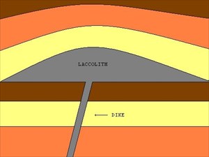
Fig: Ejemplo de un lacolito - en el caso de las Torres del Paine, el lacolito se extiende a un lado del canal en lugar de hacia ambos lados.
Hubo varias etapas de intrusión, la primera de rocas plutónicas máficas (de color oscuro) formando gabro y láminas o sills de diorita, luego le siguieron tres intrusiones posteriores de roca plutónica mas clara con los cristales mas visibles y brillantes - el granito. Los tres tipos diferentes de granito hicieron intrusión en capas, el cerro Almirante hace 12.58 millones de años, el cerro Fortaleza entre 12.58 a 12.5 millones de años y el cerro Catedral se formó con una intrusión de granito hace aproximadamente 12.5 millones de años. Existen diferencias entre ellos en cuanto a su composición química y color, aunque esto no siempre es observable para el ojo no entrenado ¡y ciertamente no a esta distancia!.
La capa formada por la intrusión del granito se puede apreciar claramente (si lo permiten las nubes) sin embargo las distinciones entre capas puede que no.
Las cuatro capas de roca plutónica terminaron bajo la antigua roca sedimentaria levantando la lutita en su parte superior, y el calor que las capas de magma le transmitieron a la lutita la convirtió en una roca mucho más resistente a las inclemencias climáticas y a la erosión que, de no haber sido por este proceso, habría sufrido.
Las erosiones subsecuentes producidas por los glaciares a lo largo de muchos años han dejado el macizo de la forma en que tu lo ves ahora, con roca sedimentaria transformada y endurecida (color oscuro) encima de un cuerpo de granito (color más claro)
Disfrútenlo.
Para reclamar este caché como encontrado, por favor envíenme un email (a través de esta página) y cuéntame:
¿cuál es el color de la gran roca (llamada errática) ubicada en S51 06.651 W073 06.959? y dime también si piensas que esta roca es sedimentaria o plutónica. Por favor no pongas fotografías de ella en el sitio web.
Segundo, ¿cuál es el nombre de la falla que, según algunos geólogos, llevo a la intrusión de lacolito en este lugar? La respuesta es Río xxxxxx. La señalética informativa en el lugar puede ayudarte.
Responderé el correo en 48 horas. Por favor selecciona la opción de incluir tu email cuando me envíes el mensaje para hacer más fácil el enviarte una respuesta.
Finalmente, pero en forma voluntaria y sin ser requisito para reclamar el cache como encontrado, por favor toma una foto de algún gabro que encuentres en el lugar y ponla en el sitio web. La señalética informativa en el lugar puede ayudarte si no sabes qué es o como luce un gabro.
Gracias por visitar este caché y este sitio tan interesante. Espero que puedas ver algunos icebergs de interesantes formas y dramáticos colores en tu camino hacia acá y de regreso.
Many congratulations to Alentium for being the first to find and HUGE thanks also to him for translating this cache into its native language.
Torres del Paine Massif Intrusion
The Laccolith
English: The Parque National Torres del Paine is an area of great beauty and amazing geology. Awarded Unesco World Heritage Status in 1978, the stars of the park are the Torres (towers) and Cuernos (horns), granite peaks that form part of the Paine Massif.
Visit this Earthcache site to marvel at the drama and the beauty of these peaks and to learn a little of how this part of the Massif was formed. As you look out over Lake Grey, with its large glacier at the far end, imagine a build up of molten rock or magma, building up in a pool way under the surface.
The pool finds a fault or small crack in the surface above it and the magma rises to the surface. This is similar to a volcano, but unlike it in that this internal movement of magma does not erupt but creates a shape like a mushroom below the surface of the earth. Gradually cooling over millions of years, the rock that is formed by this magma is called plutonic rock. The longer the cooling period the larger are the crystals formed by the minerals present in the magma.
The plutonic rocks form intrusions, also called plutons, from this cooling process, and the intrusions can then emerge to the surface. In the case before you 13 million years ago the intrusion is assumed to have entered under the existing rocks from the Lake Grey area in the form of a mushroom shape called a laccolith. The laccolith intrusion rises through a narrow space and then opens up.
Fig: Idealised picture of a laccolith – in the case of the Torres de Paine, the laccolith extends on one side of the dyke rather than on both.
There were several stages of intrusion, the first of mafic (dark coloured) plutonic rocks forming gabbro and diorite sills, followed by three further intrusions of lighter plutonic rock with the brightest and most visible crystals - granite. The three different types of granite followed as intrusions in layers. Almirante granite 12.58 million years ago. Fortaleza granite from 12.58 to 12.5 million years ago. Catedral granite was the granite entering some 12.5 million years ago. There are differences between them in chemical composition and colour although these may not be noticeable to the untrained eye and also not at this distance!
The layer of granite intrusion is however clearly visible (if the clouds allow) even if the distinction between the layers is not.
The four layers of plutonic rocks ended up underneath and lifting the older sedimentary mudstone rock on top of it and the heat transmitted to that mudstone rock from the magma layers below transformed it into a rock which is more resistant to weathering and erosion than it otherwise would have been.
Subsequent erosion by glaciers over many years have left the massif in the way you see it today, with transformed and hardened sedimentary rock (black) on top of a (lighter) granite body.
Enjoy!
To claim this cache as found, please email me (via my link on this page) what the colour is of the large rock (called an erratic) at S51 06.651 W073 06.959 and whether you think this is a sedimentary or plutonic rock. Please don't post a picture of it on the site.
Secondly - what is the name of the fault, which some geologists say led to the laccolith intrusion here? Answer is Rio xxxxxx. Again the information board will help.
I will reply within 48hrs of the email. Please tick the option to include your email in the email to me as it makes it easier to send a reply.
Finally, but voluntarily, and not required for the log, please take a photo of some gabbro that you can find at the site and post it to the site - the information board nearby will help if you don’t know what gabbro looks like.
Thanks for visiting this cache and interesting spot. I hope you will see some interesting shaped and dramatically coloured icebergs on the way here and back...
References:
Tectonic controls and Cenozoic magmatism at the Torres del Paine, southern Andes (Chile, 51°10'S) - Altenberger, Oberhänsli, Putlitz, Wemmer
Incremental growth of the Patagonian Torres del Paine laccolith over 90 k.y - Michel, Baumgartner, Putlitz, Schaltegger and Ovtcharova
Assembling a pluton…one increment at a time - Miller
The Geology of the Torres del Paine Laccolith - S.Chile - Baumgartner
Information Board at the site provided by Chilean Geological Society and Geologist Cecilia Hofling.