FRANCAIS
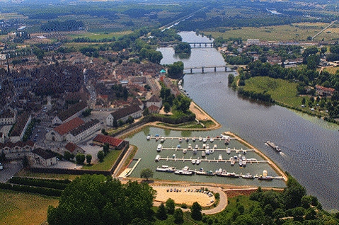
Depuis juin 2011, la ville d’Auxonne est dotée d’un port de plaisance de 150 emplacements au pied des remparts bâtis par VAUBAN.
Par cette nouvelle infrastructure, la Ville espère dynamiser son tissu économique local (commerces, cafés et restaurants) et valoriser son patrimoine historique militaire, comme l’attestent son château fortifié, construit sous Louis XI, ses remparts et son arsenal signés Vauban. Des travaux d’embellissement sont déjà prévus (éclairage des fortifications sous lesquelles seront stationnés les bateaux, aménagement de sentiers de randonnée pédestre, qui sillonneront l’une des plus grandes forêts communales de la Côte-d’Or).
Poser votre voiture au PK. Rendez vous aux coordonnées N47°11.836’ E005°23.207.
Une pancarte (que vous venez de dépasser) fixée sur les remparts vous donne une information sur le site. Comptabiliser le nombre de lettres des 5 mots (premier mot = A, deuxième mot = B…cinquième mot = E) .
Rendez vous à la cache en sachant que la direction à suivre est (A+E), et que la distance est XYZ avec : .
X= B-E.
Y=A/C.
Z=Y+D.
APPORTEZ VOTRE CRAYON.
ENGLISH
Since June 2011, the city of Auxonne has a marina of 150 places at the foot of the ramparts built by Vauban.
With this new infrastructure, the City hopes to boost its local economy (shops, cafes and restaurants) and enhance its military heritage, as evidenced by its fortified castle built under Louis XI, its ramparts and its arsenal signed Vauban. Beautification works are already planned (lighting of the fortifications which will be stationed in boats, construction of hiking trails that criss-cross one of the largest communal forests of Côte-d'Or).
Ask your car at KP. Go to coordinates N47 ° 11,836 'E005 ° 23,207.
A sign (you just exceed) fixed on the walls gives you information on the site. Count the number of letters of five words (the first word = A, B = second word ... fifth word = E).
Go to the cache, knowing that the way forward is (A + E), and the distance is XYZ with:
X= B-E.
Y=A/C.
Z=Y+D.
BRING YOUR PENCIL.

Consultez le site Geocaching en France