Alldridge Point Petroglyphs EarthCache
Alldridge Point Petroglyphs
-
Difficulty:
-

-
Terrain:
-

Size:  (other)
Please note Use of geocaching.com services is subject to the terms and conditions
in our disclaimer.
To log this EarthCache, you need to send me a message with the answers to the questions at the end of the description. Failure to do so may result in your log being deleted. I also ask that you don't "save" your find for a different day (for example to extend a streak, fill a hole in your calendar, etc.). Please log your find for the day you visited the location.
This Earthcache will take you to the coastline in East Sooke Regional Park. The rocks on the trail, and especially near the water, can be very slippery, so be careful. Do not touch the petroglyphs! They are protected by law and it is illegal to touch them! Keep in mind that cell phone reception is non-existant in parts of the park, so you may need to print out this description to take with you.
Alldridge Point Petroglyphs
Geology
The rock in East Sooke Park was formed during the Eocene epoch, which occurred between 34 and 56 million years ago. It was formed as a result of volcanic action on what was then the ocean floor. There were two major layers of rock that came from this: the Sooke Intrusions, and the Metchosin Volcanics.
The upper layer, the Metchosin Volcanics, consists of basalt. Molten rock, or magma, forced its way upward until it reached the sea floor, where it met with sea water. This caused it to quickly cool and become basalt rock.
After the Metchosin Volcanics layer had cooled, it was filled with gaps and cracks. Underneath, the still-molten magma, under extreme pressure, was pushed upward into these cracks, where it cooled more slowly. This process is called intrusion, and the name given to this layer is the Sooke Intrusions. The rock in this layer is called gabbro.
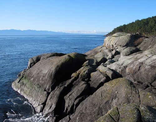
Later, when tectonic activity caused the Earth's tectonic plates to shift, the piece of the Earth's crust containing these layers was pushed on top of the existing continental plate, and above the surface of the ocean. Over time, some of the upper layer of basalt eroded away, exposing the gabbro underneath. The rock at Alldridge Point is part of one of these exposed gabbro intrusions.
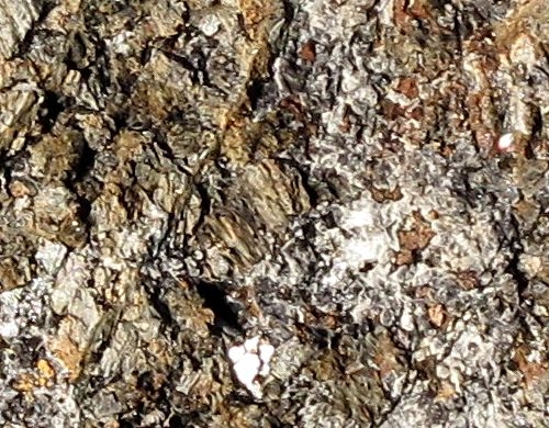
Closeup of gabbro at Alldridge Point
Since they were both formed from the same magma, gabbro and basalt are chemically equivalent, but have different crystalline structures. Basalt was cooled very quickly, so its crystals didn't have very long to form. This leads to small, fine crystals and a smoother surface. Gabbro, however, cooled more slowly, so the crystals were able to grow larger. Gabbro has coarser crystals, and a very rough surface. The gabbro at Alldridge Point is grey in colour, and contains several other minerals, including white to grey bytownite, colourless pyroxene, and yellow-green olivine.
Petroglyphs
Petroglyphs are images engraved into native rocks. The word "petroglyph" comes from the Greek words "petra", meaning "stone", and "glyphein", meaning "to carve". The petroglyphs at Alldridge Point weren't actually carved into the rock, but rather bruised into it by placing a stone against the gabbro, and hammering it with another. The rough surface of the gabbro tends to catch dirt and lichens, causing the rock to darken. When the surface is bruised, it becomes smoother, and therefore doesn't gather as much dirt. This leads to the lines being lighter than the surrounding rock. The Alldridge Point petroglyphs haven't been dated, but are thought to be thousands of years old. They were made by ancient people of the T'Sou-ke Nation, who had the following legend:
"Long years ago a great supernatural animal like a sea lion killed many of the Beecher Bay Indians while they were canoeing. The tribe nearly became extinct; the remaining members were afraid to go on the water until one day a mythical man caught the sea lion and turned him into the stone representation on Alldridge Point" (Anonymous, Report of BCPM, 1928)
The petroglyph of the sea lion can be seen at the posted coordinates. You can also make out some faint lines just west of there, at N48° 18.989 W123° 38.315 (Waypoint A), next to the metal sign.

Sea lion petroglyph
Erosion
Erosion by the ocean is slowly causing the petroglyphs to disappear. Some that were known to exist as little as 90 years ago are no longer visible. Until recently, a petroglyph of a fish was visible directly below the head of the sea lion, and there used to be another nearby at Waypoint A. Eventually, all of them will be gone. There are many forms of shoreline erosion, but the ones most likely in effect here are hydraulic action and abrasion.
Hydraulic action is the process by which waves force air into small cracks and holes in the rock. As a wave breaks onto the rock, it traps a small amount of air in the crack. The force of the wave then compresses the air, causing its pressure to increase. Over time, this action will weaken the rock, until it starts to break off.
Abrasion occurs when the breaking waves pick up small particles of sand and rock, known as scree, and smashes it against the bedrock. Think of it as being similar to sandblasting.
Eroded rocks
Questions
To log this Earthcache, please send me a message with the answers to the following questions (don't include them in your log):
1. What type of rock are the petroglyphs engraved into?
2. A. When you visited, approximately how far from the sea lion petroglyph was the edge of the water?
2. B. Were the waves reaching the petroglyph?
3. On the nearby CRD sign titled "The Petroglyphs" at N48° 19.010 W123° 38.290 (Waypoint B), "the historic artist pounded lines made of a series of _____ _____" (2 words).
4. (Optional) Post a photo of yourself or your GPSr with the sea lion petroglyph.
You don't need to wait for a response from me before logging your find. If there are any problems, I'll contact you.
Bibliography
- Harlan I. Smith, "The Petroglyph at Aldridge Point, near Victoria, British Columbia"
- J. E. Muller, "Field Trip 7: Guidebook", Geological Association of Canada, 1977
- Wikipedia
Additional Hints
(No hints available.)