A Litosfera é constituída por diversas "placas", denominadas "Placas Tectónicas", que se deslocam umas em relação às outras. Ao movimentarem-se entre si causam a deformação das rochas presentes nas zonas junto às suas fronteiras. Esta deformação pode ser frágil (falhas) ou dúctil (dobras).
A deformação pode compreender um comportamento frágil se as rochas estiverem sujeitas a baixas pressões e temperaturas muito abaixo do ponto de fusão dos minerais que as constituem. Nessas circunstâncias, como se verifica uma grande rigidez dos materiais, a deformação pode conduzir a fractura dos blocos rochosos , ou seja, à formação de FALHAS.
(Fig. 1)
Por outro lado as deformações sofrem um comportamento dúctil se as rochas estiverem sujeitas a pressões e temperaturas elevadas. Daqui resulta que as DOBRAS se formem geralmente em zonas mais profundas da litosfera, onde a temperatura é mais elevada, potenciando a deformação dúctil das rochas.
O dobramento das rochas ocorre normalmente de forma lenta no interior da crosta ou do manto. Emergem à superfície devido aos movimentos tectónicos e à erosão.
A forma das dobras é o resultado das forças a que as rochas estiveram sujeitas:
Quando a dobra é côncava (concavidade voltada para cima) encontramo-nos perante uma dobra do tipo sinclinal (ou negativa); quando a dobra é convexa (concavidade voltada para baixo) então a sua denominação é anticlinal. As dobras dizem-se neutras quando apresentam a concavidade exposta lateralmente.
(Fig. 2)
O estudo das dobras tem vindo a assumir grande relevância para os geólogos pois permite desvendar a história geológica de uma região e perceber o sentido e a intensidade das forças que agiram sobre as rochas. A disciplina que estuda a deformação causada pela interacção das placas tectónicas é a Geologia Estrutural.
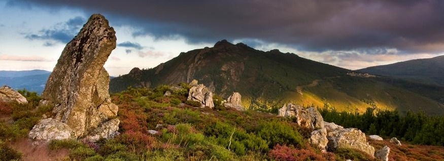
Poderão apreciar várias dobras de uma beleza extraordinária no GZ, em plena zona dos Penedos de Góis.
Pelo caminho poderão ainda encontrar com facilidade icnofósseis, marcas representativas da actividade de animais marinhos.
Como podes logar esta cache?
Envia uma mensagem com as respostas às seguintes perguntas:
-O GZ localiza-se em cima da dobra. Recolhe a altitude no GZ e em seguida dirige-te para a base e recolhe a sua altitude. Quais os dados recolhidos e a altura estimada da dobra ?
- Posicionando-te na base da dobra, qual a orientação da mesma ?
- Facultativo: Sugere-se ainda que tires uma foto a ti ou ao teu GPS junto das dobras e anexes ao teu log. Sê criativo e diverte-te.
Caches por perto:
- Convite para escutar a natureza... saborear a vida
- "Pena"... se não conseguires...
- Peneda redonda
- Penedos Altos
- Penedos de Góis
- Levadas da Pena I
- Levadas da Pena II
- Aigra Velha
As "Dobras da Pena" distam cerca de 1 Km da aldeia da Pena, local onde deverão deixar o carro e seguir a pé pelo trilho das "Aldeias do Xisto" (sinalização amarela e vermelha)no sentido Pena - Comareira (para Norte).
Venham com tempo pois vale bem a Pena!

The lithosphere consists of several "plates", called “Tectonic Plates”, which move in relation to each other. When it moves to each other causes the deformation of rocks present in the areas on their borders. This deformation may be brittle (faults) or ductile (folds).
The deformation may comprise a brittle behavior if the rocks are subjected to low pressures and temperatures well below the melting point of the minerals that constitute them. In these circumstances, as there is a great rigidity of the material, the deformation can lead to fracture of rock blocks, i.e., the formation of FAULTS.
(See figure nº 1)
On the other hand, the deformations undergo a ductile behavior if the rocks are subjected to high pressures and temperatures. It follows that the FOLDS are usually in the deepest zones of the lithosphere, where the temperature is higher, enhancing the ductile deformation of rocks. The folding of rocks usually occurs slowly within the crust or mantle. They emerge to the surface due to tectonic movements and erosion.
The shape of the folds is the result of the forces they were subject to:
When the fold is concave (concave side up) we have a synclinal fold type (or negative), and on the other hand, convex (concave down) then its name is anticline. The folds are said to be neutral have the concavity is laterally exposed.
(See figure nº 2)
The study of folds assumed great importance because it allows geologists to unravel the geological history of a region and it reveals the direction and intensity of the stresses that have acted on the rocks. The discipline that studies the deformation caused by the interaction of tectonic plates is the Structural Geology.
You can enjoy many wonderful examples of folds at GZ, at Penedos de Gois.
Along the way, you can still easily find ichnofossils, marks representing the activity of marine animals.
How can you log this cache?
Send an message with the answers to the following questions:
- GZ is located on top of the fold. Collect the elevation of the GZ and then go to the base and collect also the elevation with your GPS. What data did you collected and what the estimated height of the fold?
- Positioning yourself at the base of the fold, what is its orientation?
- Optional: We also sugest you to take a photo of you or of your GPS near the folds to attach to your log. Be creative and have fun
Caches around:
- Convite para escutar a natureza... saborear a vida
- "Pena"... se não conseguires...
- Peneda redonda
- Penedos Altos
- Penedos de Góis
- Levadas da Pena I
- Levadas da Pena II
- Aigra Velha
The "Dobras da Pena" are about 1 km distant from the village of Pena, where you should leave the car and then walk by the trail of the "Schist Villages"(yellow and red signal) in the direction to Comareira (north).
Come with time because Pena worth it well!
The most exciting way to learn about the Earth and its processes is to get into the outdoors and experience it first-hand. Visiting an Earthcache is a great outdoor activity the whole family can enjoy. An Earthcache is a special place that people can visit to learn about a unique geoscience feature or aspect of our Earth. Earthcaches include a set of educational notes and the details about where to find the location (latitude and longitude). Visitors to Earthcaches can see how our planet has been shaped by geological processes, how we manage the resources and how scientists gather evidence to learn about the Earth. To find out more click HERE.