Czech
Uvod
Jednoducha mestska multina, ktera vas zavede do mist, kde kdysi
stavalo mestske opevneni Mlade Boleslavi. Ani zaryti odpurci kesi
typu mystery se nemusi obavat. Zastavky jsou pouze dve a kes se da
cela zvladnout do 15 minut. Na uvodnich souradnicich muzete nechat
svuj dopravni prostredek. Pokud se na prvni stage nevydate primo
pres namesti, ale pujdete na zapad Belskou ulici, na jejim konci
narazite na prvni pozustatky mestskeho opevneni.
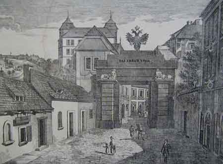
Prazska neboli Svatovitska
brana
Prvni zminka o teto brane se v mestskych pisemnostech objevuje na
konci 15. stoleti. V te dobe uz zde zrejme stala kamenna brana a
tehdy se ji rikalo Svatovitska. Zanikla v roce 1827 pri stavbe nove
silnice - jiz nevyhovovala svou sirkou. Brana byla tehdy prodana v
drazbe a nasledne zborena. Jeji existenci od te doby pripominaji
pouze dva pylony s plastikami lvu pochazejicich az z 19.
stoleti.
Brana uzavirala silnici vedouci z mesta dolu na Podolec a ke
klasteru sv. Vita - odtud take jeji nazev. Brana byla dvojita -
vnitrni brana stala na urovni dnesniho domu cp. 5, vnejsi brana
byla predsunuta o neco niz. Mezi obema branami stalo jeste nekolik
domu.
Nove Mesto sice v roce 1528, kdy dostalo stejna prava jako sousedni
Stare Mesto, obdrzelo take pravo na vybudovani hradeb, k jejich
skutecnemu postaveni vsak nikdy nedoslo. Pouze pri vyusteni
hlavnich komunikaci byly zbudovany pevne uzavery, tzv. sranky. Byl
to srank brezensky, kosmonosky a bradlecky.
Hradby Stareho
Mesta
Proti Novemu Mestu zacinalo hrazeni u Klasterske brany, pokracovalo
ke kostelu Panny Marie a odtud se obloukem stacelo do dnesni
Zelezne ulice, kde byla dalsi brana. Pred hradbou byl vyhlouben
prikop. Po stranach do udoli Klenice a Jizery zpevnovaly hradby
kruhove basty.
Opevneni mesta bylo postaveno ve 14. stoleti a vstup zajisovaly tri
(pozdeji ctyri) brany a ctyri fortny. Opevneni sestavalo z hradby s
parkanem a v mistech prepazeni ostrozny bylo doplneno vnejsim
prikopem, který se v jednom useku dochoval ve velice poskozene
forme. Na konci ostrozny stoji hrad, k nemuz se pripojovala
obvodova hradba. Belska brana na severozapade mela venkovni
prihradek v linii parkanu. Svatojanska, nekdy i Novomestska, brana
byla nejpouzivanejsim vstupem a vchazelo se do ni pres padaci most.
Vedle ni mladsi brana tvorila se Svatojanskou jeden komplex.
Zanikla zidovska brana nebyla zapojena do opevneni. Z fortny u
klastera se dochoval zazdeny kamenny oblouk v byvale bratske skole
cp. 73 Na Karmeli. Fortna u Templu slouzila jako pristup k rece a
laznim. Z opevneni se nejlepe dochoval jihovychodni usek hradby,
ktery navazuje prave na Prazskou branu.
Stage 1
Na souradnicich
N50°24.596 E014°54.066 naleznete pozustatky
fortny, ktera kdysi slouzila jako pristup k rece a laznim. Pocet
kamenu, ze kterych se torzo sklada, je vase
A.
Stage 2
Na souradnicich
N50°24.560 E014°54.117 naleznete dva lvy
sedici na sloupech. Jste u Prazske brany.
Pocet kamennych bloku, ze kterych je sloup postaven, (pocitejte
pouze na jednom sloupu a pouze stejne velke bloky - sokl a hlavici
ne) je vase
B.
Pocet kamenu ve zdi JIHOZAPADNE od lva je vase
C.
Pocet kamenu ve zdi SEVEROVYCHODNE od lva je vase
D.
FINALKA
Dosadte do teto rovnice:
N50°24.434+A*B E014°54.359-C*D. Na
vyslednych souradnicich se nachazi kes.
English
Introduction
This easy city multi-cache will take you to the places where city
walls of Mlada Boleslav have been built. There are only two stops
on the way and you will be able to make it in 15 minutes. You can
park your car at the above coordinates. If you will decide not to
go to the first stage directly across the square but you will head
west to the Belska street at the end you will see first remains of
the city walls.
Prague or St. Vitus
gate
First mention about this gate is in city documents from the end of
the 15th century. In these times the gate was made of stone and
locals called it Saint Vitus gate. The gate was destroyed in 1827
because it was too narrow for the new road to Prague. The gate was
sold in public sale and demolished. From this time only two lions
on two columns are reminding the gate. The lions were placed there
in 19th century.
The gate was at the end of the road leading down to district called
Podolec and to St. Vitus convent. The gate was double. Inside gate
was at the level of house number 5, outside gate was placed few
meters lower and there were few houses between the gates.
City walls of the Old
City
City walls where built on the place of Klasterska brana then it
continued to church of St. Maria and from this place to Zelezna
street where was another gate. There was moat in front of the
walls. On the sides to valleys of Jizera and Klenice wall was
stabilized by two forts.
City walls where built in 14th century and entrance was facilitated
by three (later four) gates and four portals. At the end of the
promontory is the castle which was connected with the city walls.
St. Johan’s gate was the most used entrance and there was the
bascule-bridge in front of the gate. Next to this gate was another
gate which has been creating one complex with St. Johan’s
gate. The abolished Jewish gate was not part of the city walls.
Portal near the Templ was used like an entrance to the river and to
the baths. From whole city walls is in best condition south-east
part which is connected to the Prague gate.
Stage 1
At coordinates
N50°24.596 E014°54.066 you will se torso of
the portal which was used like an entrance to the river and to the
baths. It consists of
A stones.
Stage 2
At coordinates
N50°24.560 E014°54.117 you will find two
lions sitting on the columns. You are at the Prague gate.
How many stone blocks was used to build the column? Count block of
same size only - not the footstall and capital. This is your
B.
Number of stones in the wall SOUTHWEST from the lion is your
C.
Number of stones in the wall NORTHEAST from the lion is your
D.
FINAL STAGE
Now solve this formula:
N50°24.434+A*B E014°54.359-C*D. The
cache is at these coordinates.
Informace prevzaty z techto webu
– sources of information:
www.stredovek.com
www.depositum.cz
www.is.mb-net.cz