|
Connection to the Earth Science
Curriculum
Essential
Question:
How
have humans positively and negatively affected Torch Lake?
Earth Science Literacy Principles-
8.3
Human activities can contribute to the frequency and intensity of
some natural hazards.
1.7
Technological advances, breakthroughs in interpretation, and new
observations continuously refine our understanding of
Earth.
3.7
Changes in part of one system can cause new changes, to that system
or to other systems, often in surprising and complex
ways.
Common misconceptions
- The
atmosphere, hydrosphere, lithosphere, and biosphere do not cause
changes in one another; these systems operate independently on
Earth.
-
Earth and its systems are too big to be affected by human
actions.
-
Human activities cannot affect geological processes like river
flow, flood cycles, etc
Michigan State Science Content Expectations
Addressed:
S.IP.07.11 Generate scientific questions based on
observations, investigations, and research.
S.RS.07.17 Describe the effect humans and other organisms
have on the balance of the natural world.
E.ES.07.41 Explain how human activities (surface mining,
deforestation, overpopulation, construction and urban development,
farming, dams, landfills, and restoring
natural areas) change the surface of the Earth
and affect the survival of organisms.
E.ES.07.42 Describe the origins of pollution in the
atmosphere, geosphere, and hydrosphere, (car exhaust, industrial
emissions, acid rain, and natural sources), and how pollution
impacts habitats, climatic change, threatens or endangers
species.
Vocabulary
Area of
Concern: A
term used by the Department of Environmental Quality to describe an
area in the Great Lakes Basin that has had major environmental
issues.
Alluvial fan- An area of dry
sediment that is deposited through gravity or human means that
forms a fan shape.
Stamp
sand: In
mining for copper there was waste left over after the basalt rock
had been crushed by a stamper to find the copper hidden in the
basalt. The stamp sand was then added to a stream of water and the
copper will fall out of the mixture because it is denser than the
remaining crushed rock. The crushed
rock was then deposited in half circle forms on the sides of
lakes. The stamp sand still has copper
in it but it is in such small amounts that it was not worth
processing further, but it is still toxic.
Superfund site: A hazardous waste site that has
been cleaned up using government money
Date
Visited: July 14,
2011
|
Torch
Lake Stamp Sands EarthCache
Lake Linden , MI.
This EarthCache site
displays several pieces of historical information from the copper
mining era in the Keweenaw. After
finding this site visitors will understand a little more about what
part Torch Lake played in the mining era and how it became an Area
of Concern.
Site :Lake Linden
Park
Materials needed for your
visit: GPS, the questions provided
in this document, a pen/pencil.
Coordinates:
N 47 °11.125’ W 88 °24.340’
Content
Explanation:
At the Lake Linden Park there is parking, restrooms,
picnic tables and a boat launch. The
sign in the picture will give a
significant amount of information needed for this
EarthCache.
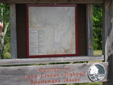
Figure 1-This is the sign you will be
looking for to help you answer the questions. Picture taken by
Julie Jenkins 7/14/11
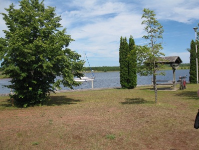
Figure 2 The park has picnic and
boating facilities. Picture taken by Julie
Jenkins7/14/11
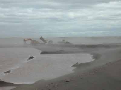
Figure 3 Hubbell/Tamarack City Stamp
Sand Parcel of Torch Lake AOC during remediation. http://epa.gov/glnpo/aoc/trchlke.html
8/8/11
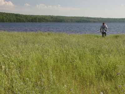
Figure 4 Hubbell/Tamarack City Stamp
Sand Parcel of Torch Lake AOC after remediation.
http://epa.gov/glnpo/aoc/trchlke.html 8/8/11
Torch
Lake was one of the first Superfund sites that the Environmental
Protection Agency funded in 1972. It
was funded due to the tumors that showed up inside and outside of
older sauger fish and walleye from the contaminated sediments found
in the lake (MDNR, 1986a; MDNR, 1987). The sediment of great concern came
from the stamp sands that had been deposited in the lake from
different mining companies during the mining era of the mid
1800’s through 1968. An
estimated 200 million tons of stamp sand was deposited into Torch Lake forming
alluvial fans, half circle formations the lakeshore and is
responsible for the toxins, such as mercury and PCB’s, found
in the lake. The stamp sand was deposited in the lake
because the sand was carried in river water and the water was then
just added to the lake with the stamp sand. After the stamp sand was deposited by the mining
companies, it was dredged out of the lake to be processed again for
any remaining copper and then deposited in the lake
again. After the government labeled
this site a Superfund site, clean sediments were brought in to
cover the stamp sand in the attempt to stop the leaching of toxins
into the lake. Questions have been
raised about the covering of the stamp sands, depleting the sand
from oxygen making the toxins even more soluble in water and doing
more harm than good.
Logging Question:
1. How
many stamp sand deposits are shown in the map at Lake Linden
Park?
2. How
many mining companies might have dumped their stamp sand
here?
Access Information:
Permission for this EarthCache was given by Village Clerk’s Office
at 906-296-9911 or visiting at 401 Calumet Street, Lake Linden, MI
49945.
References
Baker,
Shannon ( 2007).
The Michigan Department of Environmental Quality Biennial
Remedial
Action Plan Update For the Torch Lake Area of
Concern. Retrieved
from
http://www.glc.org/spac/pdf/rapupdates/Torch%20Lake%20RAP%20Final%2010.29.07.pdf
7/28/11
Simmons,
Nefertiti (2010). Region 5 Superfund
Environmental Protection Agency . Retrieved from http://www.epa.gov/R5Super/npl/michigan/MID980901946.htm
8/8/11
Rose,
Dr. William, Michigan Tech University,
Lecture, Linden Park, Lake
Linden, MI. July 14,
2011
Schaetzl,
S. (2009). Michigan Geography and Geology. J. Darden, (Assoc.
Ed).
D. Brandt, (Assoc. Ed.) New York, NY. Custom Publishing
|