|
Connection to the Earth Science Curriculum
Essential
Lessons:
Why does Great Sand
Bay look the way it does?
Earth Science Literacy
Principles-
Big Idea 3. Earth
is a complex system of interacting rock, water, air, and life.
3.2 All
Earth’s processes are the result of energy flowing and mass
cycling within and between Earth’s systems.
Common misconceptions
The
atmosphere, hydrosphere, lithosphere, and biosphere do not cause
changes in one another; these systems operate independently on
Earth.
Michigan State Science Content Expectations
Addressed:
- S.IP.M.1 Inquiry involves
generating questions, conducting investigations, and developing
solutions to problems through reasoning and
observation.
- S.IA.M.1 Inquiry includes an
analysis and presentation of findings that lead to future
questions, research, and investigations.
- P.EN.M.3 Waves
and Energy-Waves have energy and transfer energy when they interact
with matter. Examples of waves include sound waves, seismic waves,
waves on water, and light waves.
- S.RS.M.1
Reflecting on knowledge is the application of scientific knowledge
to new and different situations. Reflecting on knowledge requires
careful analysis of evidence that guides decision-making and the
application of science throughout history and within
society.
Vocabulary
Longshore drift: The transport of sediment (sand
and sometimes coarser materials like pebbles or gravel) at an angle
to the shoreline
Fetch : the distance the winds blows over open
water
Access Information:
This is a public beach owned
and operated by the Michigan Department of Transportation.
Date Visited:
Visited July 11, 2011.
|
Great Sands
Bay
EarthCache
Great Sands Bay is a beautiful white sands
beach on the Keweenaw Peninsula. It rests between Eagle
Harbor and Eagle Bay and is a great place for swimming and enjoying
an expansive shoreline. It is also a perfect stop
to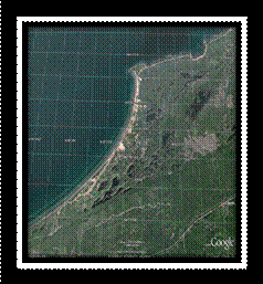 observe the geological phenomenon of
longshore
drift. observe the geological phenomenon of
longshore
drift.
Coordinates:
Stop 1: N 47 °26.822' W 088 °12.988’
Stop 2: N 47 °26.538' W 088
°13.086'
Sediment erodes by natural
forces like wind and water. The
material that erodes ends up someplace else based on its
weight, size, and make-up and also by the amount of energy the wind
and water carrying it. At Great Sand
Bay, there is a longshore drift where
sediment is carried by wave energy from one area of the beach to
another. Lighter sediments, such
as sand, need less wave energy to move and therefore drift father
along the beach than heavier sediments, such
as pebbles, which need much stronger waves to move
them. the beach than heavier sediments, such
as pebbles, which need much stronger waves to move
them.
This bay’s sandy shore is
between two large ‘arms’ called rocky
headlands. These jut into
the water and are exposed to constant waves and wind. The sediment erodes based on the strength,
direction, and the fetch of the wind.
Also, the direction and strength of the water current make Great
Sand Bay have its unique shape and make-up. Since this sediment is then made up of
smaller particles, or soft rock, it is easily transported with the
currents.
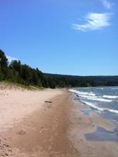
Figure 2. Great Sands Bay Shoreline by Katie
Kay
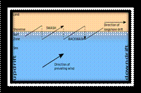
Figure 3
.
Longshore Drift Diagram. Notice how the direction of the drift is
dependent on of the prevailing wind.
http://en.wikipedia.org/wiki/Longshore_drift
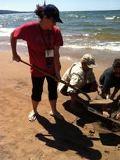 Figure 4. Student digging for sample by Katie Kay
Materials Needed
for your Visit:
GPS
Directions:
Go to stop 1 and 2 and
describe the sediment found at each location. Record your
findings.
|
Location
|
General shape
|
Color
|
Size
|
Other observations
|
|
Stop 1
|
|
|
|
|
|
Stop 2
|
|
|
|
|
Logging Question:
In which direction do you think the longshore drift
would carry particles?
Optional lesson for
school group:
Materials:
GPS, tape measure, rabbit wire, enough string for a
square meter, 4 popsicle sticks, or small sticks to hold string in
place, shovel, cloth weighing bag, and postal scale
Directions:
Before leaving make sure that
you know how to use your GPS to navigate to
waypoints.
At each given location, use the 1 meter square
string and sticks to mark off a square meter of beach. Dig approximately 1” deep, shoveling the
sand and sediment onto the rabbit wire to create a
sieve. Count the pebbles that are left
on the screen and weigh them.
|
Location
|
# of pebbles
|
Mass of pebbles (grams)
|
|
Stop 1
|
|
|
|
Stop 2
|
|
|
Logging Question:
Describe the relationship of the
number and mass of the pebbles found at each waypoint. Using
this information, then predict about how many pebbles you would
find at: 47° 25’ 30”N 88°
15’26”W.
|
|
References:
GoogleEarth. (2009)
Great Sand Bay[Image], Retrieved July
26th, 2001, from: http://www.geo.mtu.edu/~alguth/MiTEP-ESS-1/Day_1.html
Information Management
Branch of The Department of Primary Industries, Parks, Water and
Environment. (n.d.) Retrived from
http://www.environment.tas.gov.au/index.aspx?base=124
McGraw-Hill Higher Education
(Publisher). (2003). Longshore Drift of Sand [Animation], Retrieved July 26,
2011, from:
http://highered.mcgraw-hill.com/sites/0072402466/student_view0/chapter14/animations_and_movies.html
Slideshare.net (2009). Retrieved from
http://www.slideshare.net/whiskeyhj/coastal-landforms-1254812
Schaetzl, Randell J., Darden, Joe T., and
Brandt, Danita S. Michigan Geography and
Geology.
New York; Custom, 2009. Print.
Yefi
(Author). (2009). A diagram
of longshore drift [Diagram], Retrieved July 26, 2001,
from:
http://en.wikipedia.org/wiki/Longshore_drift
|