|
Connection to the Earth Science Curriculum
Essential
Lessons:
1. How do currents change the shape of
Earth’s surface?
2. How can human activities impact and
accelerate these changes on Earth’s surface?
Earth Science Literacy
Principles-
Big Idea 4.8 – Weathered and unstable rock materials erode
from some parts of Earth’s surface and are deposited in
others.
Big Idea 5.6 – Water shapes landscapes.
Big Idea 9.5 – Human activities alter the natural land
surfaces
Common misconceptions
1. Earth and its systems are too big to
be affected by human actions.
2. Human activities cannot affect
geological processes like river flows, flood cycles,
etc.
3. The Earth has always been pretty
much the way it is now.
Michigan State Science Content Expectations
Addressed:
Grade 6 & 7
S.RS.07.17
Describe the effect humans and other organisms have on the balance
of the natural world.
E.SE.06.12
Explain how waves, wind, water, and glacier movement shape the land
surface of the Earth by eroding rock in some areas and depositing
sediments in other areas.
E.ES.07.41
Explain how human activities (surface mining, deforestation,
overpopulation, construction and urban development, farming, dams,
landfills, and restoring natural areas) change the surface of the
Earth and affect the survival of organisms.
Vocabulary
Longshore Drift – the transport of sediment along a
shoreline.
Stamp Sand – is the sediment produced from the breaking down
of ore pulled from mines.
Access Information
Big
Traverse Bay is owned and maintained by the State of
Michigan. It is a public
beach.
Date Visited
July 14, 2011
|
Big Traverse Bay EarthCache
Along the eastern shore of the Keweenaw Peninsula lies Big Traverse
Bay. Visiting here gives a great
picture of how the past activities of humans can have an effect on
the environment in the future. It will
provide a vivid picture of how waves and currents are a powerful
force that can change the Earth’s surface.
Directions:
1. Before you leave make sure you know
how to use your GPS to:
*Enter and label waypoint coordinates.
*Navigate to a waypoint.
2. Navigate to each of the stops on the
tour.
3. At each stop read the introductory
material and answer the questions associated with the
stop.
Coordinates:
Big Traverse Bay is found at 47°11.362’ N, 088°14.150’
W.
Figure 1:
Aqueduct and smoke stack from the old stamp mill at Gay Sands.
Photo by J. Ernstes
Background
and History Information
Copper
mining was a major part of life andindustry
throughout the Keweenaw Peninsula from the
1840’sto
the early 1900’s. One of these
mines was Mohawk Mine in Gay, MI. The
mine took large amounts of copper ore out of the mine and
would send it to a stamp mill that was
located next to the Lake Superior coastline (picture at
right). The large smoke stack and
cement aqua duct are mostly all that remain where the stamp mill
once stood. The stamp mill consisted of
large machines that would smash and break down the rocks into small
sediment in order to separate the copper from the other
rock. An example of a stamp that still
stands is shown below. The copper was
then taken to be purified and sold for money. The other sediment, known as stamp
sands, then
was useless to the mines and had to be thrown away. The
mines looked
for somewhere open and cheap to drop these stamp sands.
Many of the mines, including this one, dumped
thesesands
into bodies of water. In this case they
deposited these stamp sands into Lake Superior. Gay, MI is located north of Big Traverse Bay along
the eastern coastline of the Keweenaw Peninsula.
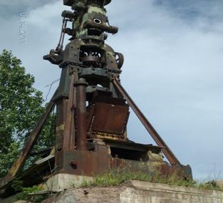
Figure 2 - Stamp
machine that was used to break up the poor rock. Photo by J.
Ernstes
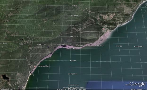
Figure 3 - Map of the eastern shore of the
Keweenaw Peninsula. http://www.geo.mtu/~alguth/MiTEP-ESS
1
Tour of Big Traverse
Bay
When you arrive at Big Traverse Bay you will notice that
there
is a boat launch along with a break
water positioned between the two beaches. This will become a very important feature in
understanding how humans have affected this area. After parking your car, walk out to the beginning
of the break water and observe the beach to the North. Look at the sand that is found on the
beach.
Logging
Q1: Describe the sand that is found
here. (Size, shape, colors,
etc.)
Next turn and look at the beach that
lies to the south of the break water at Big Traverse
Bay. If you would like you can walk
around the boat launch and go to the beach to get a better look at
what is found there.
Logging
Q2: Compare the sand found on the beach
south of the water break to the sand that is found on the north
side of the water break. (Size, shape,
colors, etc.)
Last, walk out onto the break water and observe the
beaches. This is also a great
opportunity to get a picture that shows the differences between the
two beaches. Now look back to the
north and notice that the appearance of the beach continues towards
the Gay Sands in Gay, MI. Notice that
the waves tend to hit the shoreline at an angle. Water is a very strong erosional force on earth
and can move large amounts of sediment, greatly changing the
landscape of Earth’s surface.
Since the waves hit the shores on this angle it tends to make an
overall flow of water in the direction of the angle. This is called a longshore current because it creates a current that
moves along the shore. The longshore current provides the energy to move the
sediment in the direction of the current, in this case, to the
south. This movement of sediment is
called longshore drift. Longshore drift is the
transport of sediment along a coast.
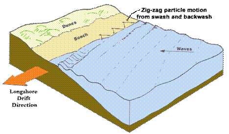
Figure 4 - Diagram of longshore drift.
http://spinner.cofc.edu/CGOInquiry/longs 1
Logging
Q3: Using what you have learned about
longshore drift and the history of the Keweenaw Peninsula, explain
what has produced the change in the beach to the north of the water
break?
References and Citations
Keweenaw Free Guide.
Retrieved from: http://keweenawfreeguide.com/gay-sands-upper/
[Lonshore Drift
Diagram].
Retrieved July 25, 2010, from:
http://spinner.cofc.edu/CGOInquiry/longshoredrift.htm?referrer=webcluster&
[Map of Keweenaw Peninsula].
Retrieved July 25, 2010, from:
http://www.geo.mtu.edu/~raman/SilverI/MiTEP_ESI-1/Day_4_Keweenaw_Stamp_Sands.html
Rose, Bill. MiTEP Website. Retrieved
from: http://www.geo.mtu.edu/~raman/SilverI/MiTEP_ESI-1/Welcome.html
Schaetzl,
Randall J., Joe T. Darden, and Danita S.
Brandt.
Michigan Geography and
Geology. New
York: Custom, 2009. Print.
|