Ponta da Fajã EarthCache
-
Difficulty:
-

-
Terrain:
-
Size:  (other)
Please note Use of geocaching.com services is subject to the terms and conditions
in our disclaimer.
[PT] Ponta da Fajã
A sensivelmente 2 km a norte da Fajã Grande fica situada uma pequena povoção que dá pelo nome de Ponta da Fajã. Esta povoação existe desde o século dezasseis. A quem se aproxima, ao longe avista a igreja branca de Nossa Senhora do Carmo, datada de 1898. Ponta da Fajã é um lugar cingido por montanha e mar. Seguir à ponta da Fajã existe uma subida para Ponta Delgada, um antigo trilho de trabalho, hoje muito apreciado por caminhantes sendo um trilho de referência nos Açores e mais concretamente na Ilha das Flores.
Próximo das coordenadas esteve há mais ou menos 25 anos um bar que oferecia refrescos. O que aconteceu para que de um dia para o outro a Ponta da Fajã se tornasse numa “Zona de alto risco“ e assim numa “Cidade fantasma”?
Após chuvadas fortes que duraram dias, atrás da igreja deu-se uma derrocada de grande parte da encosta que caiu por duas fases. Por milagre não houve feridos entre a população no entanto a derrocada destruiu muitos campos de cultivo e algumas casas. Os vestígios desta desgraça ainda hoje são visíveis pois a vegetação só muito lentamente recupera o seu terreno.
Deslizamento de terra
Um deslizamento de terra é um fenómeno geológico que inclui um largo espectro de movimentos do solo, tais como quedas de rochas, falência de encostas em profundidade e fluxos superficiais de detritos. Existem varias factores em acção:
- A erosão pelos rios, glaciares ou ondas oceânicas
- As encostas de rocha e solo são enfraquecidas por via da saturação com água proveniente do degelo ou de grandes chuvas
- Sismos
- Erupções vulcânicas
- Maquinaria o tráfego
- O excesso de peso por acumulação de chuva ou neve, deposição de rochas ou minérios, pilhas de resíduos ou criado por estruturas feitas pelo homem podem também acumular tensões sobre encostas frágeis até à sua falência.
- Aluimento: Em geologia, chama-se aluimento a um tipo de deslizamento de terras sobre outro local de menor altitude, que pode ser provocado pelo avanço dos glaciares, por chuva intensa ou por um terramoto. Este fenómeno pode dar-se tanto em terra como no fundo dos oceanos.
Fontes: “Ilha das Flores - Açores - Roteiro histórico e pedestre” , Pierluigi Bragaglia, 2009 e „Wikipedia.pt“
Sobre a EarthCache
Perguntas:
1. Quando aconteceu o deslizamento, cujos vestígios ainda hoje se podem ver acima de Ponta da Fajã ? (mês e ano)
2. Que consequências teve para os habitantes de Ponta da Fajã?
3. Indica outros deslizamentos de terra que aconteceu em Flores.
Também e apesar de ser opcional, por favor, tire uma foto no local com o seu GPS e mostre-a juntamente com o seu log.
Envie as respostas através do nosso perfil geocaching antes de efectuar o log do cache. Daremos feedback a autorizar.
[ENG] Ponta da Fajã
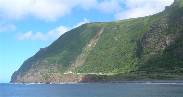
About 2 kilometres north of Fajã Grande you’ll find the small village of Ponta da Fajã, its origin to be traced back until 16th century. From afar you’ll make out the church Nossa Senhora do Carmo, gleaming white.
Ponta da Fajã, a village tightly enclosed by escarpment and coastline. At its rear, the ascent towards Ponta Delgada is beginning, small trade route of old, a popular hiking trail today. Next to given coordinates and about 25 years ago, there was a little pub. From one day to the next, Ponta da Fajã was declared ‘ghost town’ and ‘high risk area’ (zona de alto risco). What had happened?
Just behind the church and due to vehement rainfall lasting for days, a significant part of the rocky escarpment came loose and crashed down in two stages. It’s near a miracle that nobody was injured. The rockslide, however, destroyed numerous fields and a few buildings. Difference to adjacent areas reveals the trace of devastation because plants didn’t grow yet to original size.
By the way, since year 2009 a commission check to abolish the ‘zona de alto risco’ - The end of a ‘ghost town’?!
Landslide - Rockslide
A landslide is a geological phenomenon which includes a wide range of ground movement, such as rockfalls, deep failure of slopes and shallow debris flows, which can occur in offshore, coastal and onshore environments. Although the action of gravity is the primary driving force for a landslide to occur, there are other contributing factors affecting the original slope stability. Typically, pre-conditional factors build up specific sub-surface conditions that make the slope prone to failure, whereas the actual landslide often requires a trigger before being released.
A rockslide is a type of landslide caused by rock failure in which part of the plane of failure passes through intact rock and where material collapses en masse and not in individual blocks.
Causes:
- weakening of a slope through saturation by snowmelt, glaciers melting, or heavy rains
- erosion of the toe of a slope by rivers or ocean waves
- earthquakes or volcanic eruptions
- loss or absence of vertical vegetative structure, soil nutrients, and soil structure, often after a wildfire
- deforestation, cultivation and construction, which destabilize the already fragile slopes
- vibrations from machinery or traffic
- blasting or mining
About the Earthcache:
Three questions to answer:
1.When did the rockslide come down onto the village, the trace of which is still obvious? (Month and Year are enough.)
2. What were the consequences for Ponta da Fajã people?
3. Name another rockslide on Ilha das Flores.
If you want, take a photo of you and your GPS (or only your GPS) from that part of escarpment where the rocks came falling down.
Send us the answers via our geocaching profile before logging the cache. We will get back to you with the permission to do so.
[DE] Ponta da Fajã
Rund zwei Kilometer nördlich von Fajã Grande befindet sich der seit dem 16. Jahrhundert existierende kleine Ort Ponta da Fajã. Schon von weitem leuchtet einem die 1898 erbaute weiße Kirche „Nossa Senhora do Carmo“ entgegen.
Ponta da Fajã, ein Ort eng umschlossen von Bergwand und Meer. Am hinteren Ende der Aufstieg nach Ponta Delgada. Ein alter Wirtschaftsweg, der heute auch bei Wanderern beliebt ist. Ungefähr an den Koordinaten befand sich vor rund 25 Jahren eine Bar, die Ausflüglern Erfrischungsgetränke anbot. Von einem auf den anderen Tag wurde Ponta da Fajã zur „Zona de alto risco“ (Gefahrenzone) erklärt und somit eine „Geisterstadt“. Was war passiert?
Direkt hinter der Kirche löste sich infolge tagelanger starker Regenfälle ein Teil der Felswand und krachte in zwei Phasen zu Tale. Wie durch ein Wunder kamen keine Menschen zu Schaden.Der Bergsturz zerstörte jedoch etliche Felder und ein paar Häuser; die Sturztrasse ist auch Jahre später noch deutlich zu erkennen, weil in ihrem Verlauf die ursprüngliche Vegetation erst allmählich wieder zu voller Größe heranwächst.
Seit 2009 ist eine Prüfkommission dabei, die „Zona de alto risco“ wieder langsam aufzuheben. Das Ende einer Geisterstadt?
Bergsturz
Ein Bergsturz ist eine Fels- und Schuttbewegung an Bergflanken. Bei Bergstürzen gerät das Gestein großräumig in Fluss; es verhält sich ähnlich wie Wasser und kann sogar an gegenüberliegenden Hängen „aufbranden“. Die Ablagerungsgebiete können Volumina von Millionen Kubikmetern und Flächenausdehnungen von mehr als 10 Hektar erreichen. Unter Geographen werden Bergstürze als Fels- und Schuttbewegungen definiert, die in Windeseile niedergehen, ein Volumen von >1 Millionen Kubikmeter besitzen und eine Fläche von über 10 Hektar abdecken. Die Auswirkungen von Bergstürzen können verheerend sein. In den zurückbleibenden Schuttmassen bilden sich oftmals kleinere Seen.
Ursachen:
- Die häufigste Ursache ist, dass der Erdboden am Hang zu große Mengen an Wasser, beispielsweise infolge heftiger Gewitterregen oder durch Schneeschmelze, aufgenommen hat. Wegen zu geringer innerer Haftreibung folgt daraus ein Verlust der Stabilität einer Gleitfuge entlang.
Andere mögliche Ursachen sind
- Erdbeben
- tektonische Bewegungen
- Erosion durch Wind und Frost
- starke Abholzung des bestehenden Waldes
- Schädigung des Erdbodens durch ausgedehnten Bergbau oder Straßenbau
Nun zum Earthcache:
Drei Fragen sind zu beantworten:
1. Wann ereignete sich der Bergsturz, dessen Spuren noch heute offenkundig sichtbar sind? (Monat und Jahr genügen.)
2. Welche Folgen hatte der Bergsturz für die Bewohner von Ponta da Fajã ?
3. Nenne einen weiteren Bergsturz auf Flores.
Wenn du magst, nimm ein Foto von dir und deinem GPS (oder nur dem GPS) an der Stelle auf, wo der Bergsturz niederging.
Schickt die Lösung bitte an unsere Profil-Emailadresse. Wenn alles richtig ist, senden wir euch eine Antwortmail zur Logfreigabe.
Additional Hints
(No hints available.)