
Em petrography, leucocraticas um termo proposto por Brögger (1896) para designar rochas igneas caracterizadas por uma preponderância de minerais de cor clara, ou então de minerais que são normalmente claros (feldspato, minerais de feldspato e quartzo), a contrastar com aquelas (melanocraticas) nas quais existe uma preponderância de minerais de cor escura.
Rochas ígneas são aquelas que se formaram a partir de lava (magma), ela própria um produto da fusão de partes no interior da Terra. As rochas ígneas dispõem de uma variedade de composições, cores, tamanho de grão, e outros atributos. Muito do esforço cientifico tem-se centrado no como se formaram as rochas ígneas mas, devido a que é difícil observar e medi-las a uma temperatura e pressão relevante, a busca da explicação da formação das rochas ígneas tem-se centrado nas próprias rochas. O estudo de como as rochas se formam é conhecido como petrogenese. A pesquisa de rochas ígneas incluiu a identificação de minerais e determinou a concentração de elementos químicos nelas. Cada tipo de estudo produziu o seu proprio sistema e nomenclatura, consequentemente, classificação. Estas classificações conseguem estereotipar as rochas embora, apesar de úteis, tendem a concertar que existe um continuum na composição das rochas.
Ácida - Básica: Uma simples classificação baseada no conteúdo de silica (SiO2) da rocha. Rochas com menos de 45% de peso de SiO2 são chamadas de ‘ultrabasica’; 45%–52% de SiO2, ‘basica’; 52%–66% ‘intermédia’; e com mais de 66% ‘acida’. os termos 'ácida' e 'básica' não pretendem expressar a ideia de que as rochas são ácidas ou alcalinas no habitual sentido da palavra; são usadas meramente para descrever o conteúdo de silica na rocha. Rochas que são ricas em sílica ('acidas' ou silicas) são comummente (com nota de excepção para a obsidiana, um vidro vulcânico preto) leucocratica (pálida na côr), enquanto rochas 'basicas' são pretas o mesmo que dizer melanocraticas. Os termos leucocratica e melanocratica podem ser substituídas por felsica e mafica, respectivamente. As categorias 'ultrabasica', 'basica', 'intermédia' e 'ácida' podem ser subdivididas em vários tipos tendo em consideração o tamanho do grão, concentrações de outros elementos, ou o conteúdo mineral da rocha.
Classificação por tamanho grão: Rochas de composições idênticas podem ser distinguidas de cada uma na base do tamanho do seu grão. A Fig. 1 mostra como as rochas em cada grupo composicional podem ser adicionalmente subdivididos desta forma. Rochas com um grão mais pequeno são aquelas que arrefeceram mais rapidamente; elas tendem a ser associadas com vulcões, intrusões perto da superfície, pedras de grão áspero são mais prováveis de serem plutónicas (formadas dentro da crosta) de origem. Este método de classificação por composição e tamanho de grão pode ser realçado pela adição de qualificadores; por exemplo, um "gabbro" (mantido do original) onde a olivina é proeminente é chamada de olivina "gabbro", ou uma "rhyolite" que é fortemente agregada pode ser chamada de "rhyolite" agregada.
Fig. 1. A classificação tradicional de rochas igneas baseado no seu conteúdo de silica (‘ultra-basica’ a ‘acida’) e tamanho de grão.
Os métodos de classificação detalhada acima são extremamente úteis para dar nome ás rochas no terreno. Embora um campo geológico não possa necessariamente identificar todos os minerais na rocha, e quase certamente não será capaz de calcular o seu conteúdo em sílica, as pistas dadas pela cor, pelo tamanho, e minerais imediatamente identificáveis permitem um nome baseado no sistema em que será catalogado. Análises de laboratório da concentração de numerosos elementos nas rochas ígneas tornam possível definir mais pequenas e mais especificas categorias que podem, por exemplo, atingindo as concentrações relativas de potássio e sódio. Alguns outros métodos de análise e classificações de rocha são enumeradas abaixo.
Apesar do termo “acida”, “intermédia”, “básica” e “ultrabásica” são potencialmente erróneas do ponto de vista da composição química da rocha, o seu uso mantém-se porque são palavras muito bem estabelecidas e porque todos os geólogos percebem o seu verdadeiro significado.
Fonte da internet e mais informação: here
 Igneous rocks are those that form from molten rock (magma), itself a product of the melting of parts of the Earth's interior. Igneous rocks display a variety of compositions , colours, grain sizes, and other attributes. Much scientific effort has focused on how igneous rocks have formed but, because it is difficult to observe and measure them at the relevant temperature and pressures, the search for the explanation of igneous rock formation has centred upon the rocks themselves. The study of the way in which rocks are formed is known as petrogenesis. Research on igneous rocks has included the identification of the minerals and the determination of the concentrations of the chemical elements in them. Each type of study has produced its own system of nomenclature and, hence, classification. These classifications place the rocks into pigeonholes which, although useful, tend to conceal the fact that there is a continuum of rock compositions.
The proliferation of igneous rock names that were based upon the names of the localities at which type specimens of the rocks were found introduced unnecessary confusion. The Subcommission on the Systematics of Igneous Rocks of the International Union of Geological Sciences (IUGS) has a glossary of more than 1500 rock terms, from ‘A-type granite’ and ‘abessedite’ to ‘zobtenite’ and ‘zutterite’ (an erroneous spelling of ‘rutterite’). The subcommision has made a strong recommendation that the naming of rocks should be simplified and standardized in accordance with the guidelines laid out in their book (see Further reading).
Acid–basic
One simple classification is based upon the silica (SiO2) content of the rock. Rocks with less than 45 per cent by weight SiO2 are termed ‘ultrabasic’; 45–52 per cent SiO2, ‘basic’; 52–66 per cent ‘intermediate’; and more than 66 per cent ‘acidic’. The terms ‘acidic’ and ‘basic’ are not intended to express the idea that the rocks are acidic or alkaline in the customary sense; they are employed merely to describe the silica content of the rock. Rocks that are rich in silica (‘acid’ or silicic) are commonly (with the notable exception of obsidian, a black volcanic glass) leucocratic (pale in colour), while ‘basic’ rocks are darker, that is melanocratic. The terms leucocratic and melanocratic may be replaced by felsic and mafic, respectively. The simple categories ‘ultrabasic’, ‘basic’, ‘intermediate’, and ‘acidic’ can be subdivided in a number of ways by consideration of grain size, concentrations of other elements, or the mineral content of the rock. Common felsic minerals include quartz, muscovite and orthoclase.
Grain-size classification
Rocks of identical composition can be distinguished from each other on the basis of their grain size. Figure 1 shows how rocks in each compositional group can be additionally subdivided in this way. Rocks of smaller grain size are those that have cooled quickly; they tend to be associated with volcanoes and near-surface intrusions, coarser-grained rocks are most likely to be plutonic (formed within the crust) in origin. This method of classification by composition and grain size can be enhanced by the addition of qualifiers; for example, a gabbro in which olivine is prominent is called an olivine gabbro, or a rhyolite that is strongly banded may be called a banded rhyolite.
Fig. 1. A traditional classification of igneous rocks based on silica content (‘ultrabasic’ to ‘acid’) and grain size.
The methods of classification detailed above are extremely useful for the naming of rocks in the field. Although a field geologist cannot necessarily identify all the minerals in the rock, and almost certainly cannot calculate the silica content, the clues yielded by colour, grain size, and readily identifiable minerals allow a field name based upon the system to be assigned. Laboratory analysis of the concentrations of numerous elements in igneous rocks makes it possible to define smaller and more specific categories that can, for example, hinge upon the relative concentrations of potassium and sodium. Some other methods of rock analysis and classification are summarized below.
Although the terms ‘acidic’, ‘intermediate’, ‘basic’, and ‘ultrabasic’ are potentially misleading from the viewpoint of the chemical composition of a rock, their use persists because they are well-established words and because all geologists understand their true meaning.
CIPW-norm
An igneous rock of given chemical composition (of elements) usually contains crystals of the same minerals (crystalline molecules) as other rocks of that composition. Figure 2 shows the minerals that are associated with the various silica contents of igneous rocks. This led to the use of the CIPW-norm in the classification of rocks. The CIPW-norm was developed in 1902 by four eminent petrologists who also left the initial letters of their surnames (Cross, Iddings, Pirrson, and Washington) to posterity. Using their knowledge of coarse grained rocks and the results of chemical analysis, they were able to reconstitute their samples theoretically as if they were coarse-grained. This operation allowed rocks of different grain size to be compared in terms of their bulk chemistry with recourse to only a few simple rules and some elementary, but tedious, arithmetic. Comparison of the normative composition of basalt, which is very fine grained, with gabbro, which is coarse grained, shows that the two are identical in CIPW-norm terms. This implies that, apart from their cooling history, they have a similar petrogenesis. Modem techniques for the determination of bulk chemistry have made analyses widely available for comparison with one another, and the CIPW-norm as an intermediary has become largely redundant. However, as many rock analyses in the literature have been classified in terms of the CIPW-norm, it is still a standard method of classification.
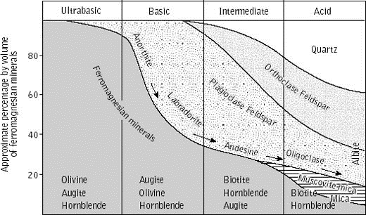
Fig. 2. Proportions of minerals in igneous rocks classified according to where they are located on the ‘ultrabasic’ to
Rock analysis
In the past, the concentrations of major elements (those that make up more than 1 per cent by weight) of the rock were determined by wet chemistry, a long and tedious process which had to be performed by specialists. Modern analytical tools include X-ray fluorescence, a technique by which the quantities of major and trace elements (those that make up less than 1 per cent by weight) of a rock can be determined. Analysis for major and trace elements is thus now relatively fast and can be performed by less expert chemists, provided that the equipment is available. This change in analytical procedure has led to a change of emphasis in rock nomenclature, now that there are enough analyses to consider the mean and variance of the rock compositions. A sample may include rocks that fall into a number of different named categories, even though analyses cluster as though they were the result of the same geological process or set of processes.
Harker plots
As a means of addressing these new data sets, the use of element–element plots (Harker diagrams), a method first used in 1909 by Alfred Harker, has become widespread (Fig.3). After plotting, the rocks can be divided and assigned names according to where they plot on the graph. An enormous variety of different indices has also been used to split groups of rocks more finely and thus assign names to the groups. The user should ascertain, before applying such an index plucked from the literature, what the index represents and what he or she expects from it.
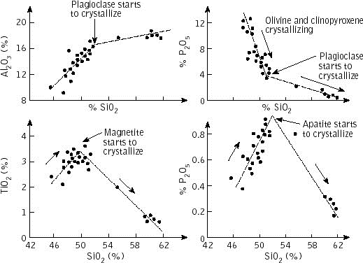
Fig. 3
Spider diagrams
The spider diagram (Fig. 4) has become a popular tool in the analysis oftrace-element compositions. Spider diagrams overcome the difficulty of plotting elements whose concentrations vary over several orders of magnitude by normalizing the elemental concentrations to a carefully chosed standard known as a norm. Common normalization standards include the concentrations of trace elements in chondrites (meteorites that are thought to have the same composition as the Earth) and MORB, the mean composition of normal (as opposed to enriched) mid-ocean ridge basalts. The compositions relative to the norm are plotted against the element names and a comparison of rocks or groups of rocks is made. It should be borne in mind that normalized values express the relative concentrations of elements to the norm and that the actual values of the elemental concentrations have been obscured.
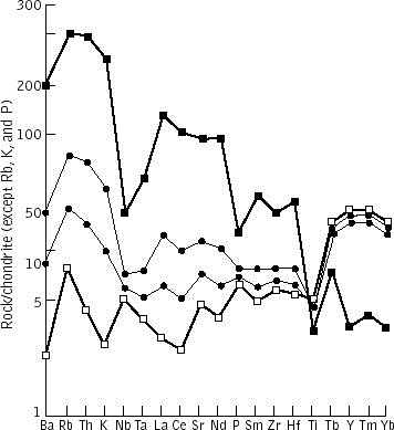
Fig. 4. Spider diagram illustrating normalized element compositions in a range of igneous rocks.
Rare-earth elements (the elements lanthanum (La) to lutetium (Lu) are also normalized and plotted in this way (Fig.5). Rare-earth elements (REE) are particularly useful in petrogenetic studies because they are chemically similar to one another and they are incompatible; when a small amount of melting occurs they move from the solid phase into the melt. Incompatible elements are hence very mobile and can move with extremely small melt fractions. This fact accounts for the extremely variable concentrations of these elements in rocks and the plethora of rock names that they have spawned. Incompatible elements are much invoked in the study of melting, particularly where small degrees of melting have occurred.
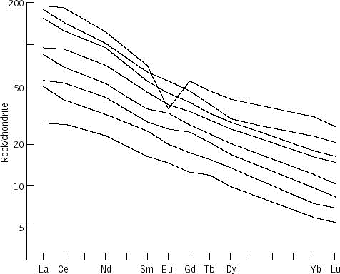
Fig. 5
The naming of rocks began with field names that were assigned so that a rock, or group of rocks, could be labelled easily in the field. As methods of analysis proliferated, and hence the criteria that could be used to discriminate between rocks became more numerous, so the range of names has snowballed. Now that modern analytical techniques can determine the concentrations of almost every element in the periodic tabele, there is a movement away from intensive naming of rocks towards a statistical treatment of multi-element data. Erstwhile names such as kulaite (a particular type of volcanic rock from the village of Kula in western Turkey) have been subsumed by much broader categories like ‘alkali-basalt’. In time, more and more use will be made of statistical analysis of data to describe rocks that fall into a few named categories. Indeed, it is essential to replace a proliferation of rock names with a sound knowledge of the petrogenetic origin of the rocks but, at the same time, to avoid generating, in their place, too many complicated ‘black-box’ diagrams of one index against another. Modern petrogenetic studies are deeply involved in the study of the different environments in which igneous rocks occur, and in mo-delling the processes that lead to the range of rock types and compositions observed.
Bibliography and More Information about igneous rock classification
- le Maitre, R. W. (ed.) (1989) A classification of igneous rocks and glossary of terms, recommendations of the International Union of Geological Sciences Subcommission on the Systematics of Igneous Rocks. Blackwell Scientific Publications, Oxford.
- Kennet, P. and Ross, C. A. (1983) Igneous rocks. Longman Group Resources Unit, York.
- Wilson, M. (1989) Igneous petrogenesis: a global tectonic approach. Unwin Hyman, London.
Source from internet and more information: here
Work done by: Judith M. Bunbury
one of many applications / uma de muitas aplicações
The Monte Farinha's Quarries
There are a great number of quarries in the Monte Farinha. In scale they are placed all over the mountain in a radius near the 3km with an area of almost 30km2. They are sub-divided in small quarries achieving a number greater the 14 spots (2010), covering an area of exploitation with a total amount rounding 17km.
The environment effects are obvious, a glance at them is all it takes to imagine the effect in the surrounding fauna and flora, and by that matter the people who live nearby.
As Pedreiras do Monte Farinha
Existe um grande número de pedreiras no Monte farinha. Em escala, estão colocadas por toda a montanha num raio de aproximadamente 3km com uma área de quase 30km2. Estão subdivididas em pequenas pedreiras atingindo um número de 14 spots (2010), cobrindo uma área de exploração num total que ronda os 17km.
Os efeitos ambientais são obvios, basta um olhar na sua direcção para imaginar o efeito na fauna e flora envolvente, e por esse motivo as implicações para as pessoas que vivem por perto.
HOW TO CLAIM THIS CACHE
To claim this cache you must answer the following questions, through this mail in order to let us know if you have readed and learned something about this type of stone, so peculiar and commun in this part of Portugal. Its used as ornament and as several types construction forms: worked stone (an example the coat of arms of the ancient mannor houses), tiles, pavement tiles, walls, façades, window's frames, etc etc. It's also called the "Mondim's (find out the colour) stone"  . Answers gaven through logs are not allowed. Such logs will be immediately deleted.
1. - Looking towards the Monte Farinha's quarries which is the main colour observed: Red? Black? Ligh Yellow?
2. - Wich is the percentage for a rock to be called "acid" or "silic"?
2.1- What makes the colour of the stone watched:
a) quartz, b) muscovite c) orthoclase d) all of them
3 - Wich is the term that classifies a light coloured stone? and a dark one?
4 - Determine, from where you're standing the "size" of the bigger quarrie in meters. Answer could be the height, the width, both or square meters.
5 - Should post a pic with an application of this stone in the monuments, houses, churches, pilloryes, open spaces, that you may observe. It is the first exercise when coming to this EC. An example could be the spaces around the Celorico de Basto or Mondim de Basto Tawn Hall, all made of that material. But it is everywhere. Just pic it. It will be made a selection of the best pics received till end 2011. Those pics will enter this cache listing. Chosen pics owners will be contacted till the end of 2011. Due to the new rules of Geocaching the point 5 is not compulsory, but it would be much appreciated as an complimentary exercise, and they will be taken in consideration when answering.
COMO RECLAMAR ESTA CACHE
Para reclamar esta cache devem responder ás questões abaixo, através deste mail para nos permitir saber se leram e aprenderam algo sobre este tipo de pedra, tão peculiar e comum nesta parte de Portugal. É usada em vários tipos e formas de construção: pedra talhada (um exemplo são os brasões da antigas casas de brasão da zona), tijolerias, chão, paredes, fachadas, molduras e janelas, etc etc. É também conhecido como a "pedra (descubram a côr) de Mondim) . Respostas dadas através de logs não estão permitidas. Esse tipo de logs serão imediatamente apagados.
1. Olhando na direção das pedreiras do Monte Farinha qual é a cor principal observada: Vermelha? Preta? Amarelada?
2. Qual a percentagem para uma pedra ser classificada como "Acida" ou "Silica"
2.1 - O que produz a cor desta pedra:
a) quartzo, b) Muscovite, c) orthoclase d) todas as anteriores
3. Qual é o termo que classifica uma pedra de côr clara? e uma de côr escura?
4. Determinar, do local onde estão colocados "o tamanho" da pedreira maior em metros. A resposta pode ser a altura, a largura, ambos ou metros quadrados.
5. Devem colocar colocar uma foto com uma aplicação deste tipo de pedra nos monumentos, nas igrejas, nos pelourinhos, nas casas, nos espaços públicos etc. Será o primeiro exercicio quando vierem fazer esta EC. Um exemplo pode ser a zona envolvente da câmara munipal de Celorico de Basto ou de Mondim de Basto. Mas existe em qualquer lado. É só procurar. Fotografem e postem. Será feita uma selecção das melhores fotos para integrar o listing da cache. Os escolhidos serão contactados até final do ano 2011. O ponto 5 não é obrigatório pelas novas regras do Geocaching, mas agradece-se que o façam enquanto exercicio complementar, e a ter em conta aquando das respostas.
One of many by:
ENJOY IT!