Marocche di Dro - Welcome to the Moon EarthCache
Marocche di Dro - Welcome to the Moon
-
Difficulty:
-

-
Terrain:
-

Size:  (other)
Please note Use of geocaching.com services is subject to the terms and conditions
in our disclaimer.
MAROCCHE DI DRO - WELCOME TO THE MOON
Deutsche Version
Die Marocche di Dro sind Teil eines noch größeren Bergsturzgebietes, welches die Einheimischen Le marocche, was etwa mit „Gesteinshalden“ zu übersetzen ist. Die Gesteinsmassen stammen vom Monte Brento (1544 m) und Monte Casale (1632 m). Sie haben in mehreren Abgängen ein etwa acht Kilometer langes und teils über zwei Kilometer breites Gelände im Talboden zwischen Dro und Pietramurata verschüttet. Das Gesamtvolumen der Gesteinsblöcke wird auf rund 1 Milliarde Kubikmeter geschätzt. Wann das Material abstürzte, ist von den Forschern noch nicht hinreichend geklärt. Die Seen, z.B. der Cavedinesee die sich dort in der Folge aufgestaut haben, dürften ein Alter von mehreren Jahrtausenden haben.
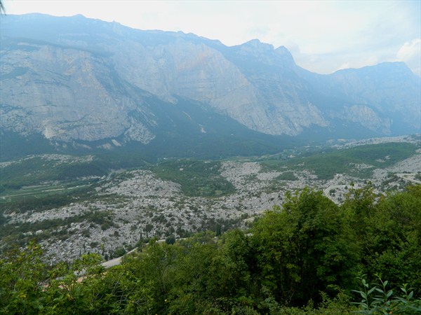
Als sich die eiszeitlichen Gletscher zurückzogen, begann bis in die frühere Neuzeit hinein der wiederholte Abbruch ganzer Felswände vom Monte Casale und Monte Brento und verschütteten das Tal. Bis ins 19. Jahrhundert bildeten diese scharfkantigen Gesteinsmassen eine fast unpassierbare Sperre. Auf einer Länge von mehreren Kilometern reihen sich gewaltige Felsblöcke mit kleinerem Schutt aneinander, die ein Durchkommen nur mit gutem Schuhwerk möglich machen.
Seit 1986 ist "la Marocche" als offizielles Naturschutzgebiet anerkannt, das nur auf den dafür vorgesehenen, markierten Pfaden erwandert werden sollte!
Nicht zu unterschätzen ist allerdings, trotz der geringen Steigungen, das äußerst scharfkantige und zum Teil lose Gestein - und die brütende Hitze! Auch gibt es keine Einkehrmöglichkeit...wie gesagt, WELCOME TO THE MOON!
UM DIESEN EARTHCACE ZU LOGGEN,BEANTWORTET BITTE FOLGENDE FRAGEN:
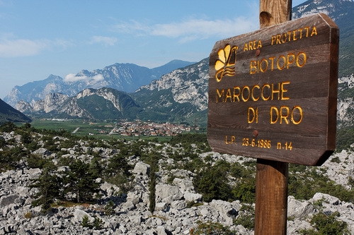
Bei N 45.59.032 und E 010.56.456
findet ihr eine Informationstafel, die euch helfen wird, allerdings ist diese wohl derzeit futsch - keine Panik, die Antworten kann man durchaus per Suchmaschine aufspüren!
1. Über welches Gebiet verteilt sich die Steinwüste "la marocche" ungefähr?
Angabe bitte in gerundeten Quadratkilometern!
2.Wodurch entstand dieses gigantische Geröllfeld?
3.Begebt euch zu
N 45.59.028 E 010.56.450
Schätzt den ungefähren Umfang dieses großen Findlings!
4. (OPTIONAL)
Erklimmt diesen Felsen,stellt euch mit eurem GPS Gerät in Pose und hängt dieses Foto eurem Log an, denn
FOTOLOG = EHRENKODEX !
Logfreigabe muß NICHT abgewartet werden - falls mit euren Antworten etwas nicht stimmt, melde ich mich!
Logs MIT Foto wären schön! ,-)

Italiano, Grazie Mille Claudia (Topona)!
Le Marocche di Dro sono parte di un'area di frana ancora più estesa, localmente chiamata "Le Marocche".
In dialetto trentino "Marocca" significa ammasso di pietre, con una probabile origine dal termine paleoeuropeo "mar", pietra. Il deposito di frana si è originato dal distacco di consistenti masse rocciose del Monte Brento (1544 m) e dal Monte Casale (1632 m).
Questo impressionante deposito si estende su un'area con dimensioni di circa 5 per 2 miglia, nella valle tra Dro e Pietramurata. Il volume totale del deposito, costituito da blocchi di roccia, è stimato in circa 1 miliardo di metri cubi (pari a 1 km cubo). Non è ancora sufficientemente chiaro ai ricercatori quando sia effettivamente avvenuto il collasso. I laghi originatisi a causa dello sbarramento formato dal deposito di frana, come quello di Cavedinese, hanno presumibilmente un'età di diverse migliaia di anni. Quando i ghiacciai iniziarono a ritirarsi, venne a mancare il supporto ai versanti del Monte Casale e del Monte Brento, che collassarono, seppellendo di materiali rocciosi la valle.
Fino al diciannovesimo secolo questo deposito costituiva, con i suoi grossi blocchi di roccia, una barriera quasi invalicabile, lunga diversi km, dove solo buone scarpe e la presenza di detrito più fine tra i blocchi permettevano di percorrerla. Dal 1986 le Marocche sono state riconosciute ufficialmente come riserva naturale, entro la quale è suggerito avvalersi dei sentieri tracciati. Nonostante le deboli pendenze, l'area non va sottovalutata, sia a causa della natura aspra del paesaggio che soprattutto del caldo torrido. Non ci sono fonti di acqua, quindi assicuratevi di averne una scorta sufficiente con voi prima di affrontare la passeggiata ... e come dicevo, BENVENUTI SULLA LUNA!
Per loggare la cache, dovrete rispondere alle seguenti domande:
Al punto N 45.59.032 E 010.56.456 troverete un pannello informativo che vi aiuterà.Attenzione Il pannello non è attualmente ci!
1.
Su quale area è distribuito il deserto roccioso delle Marocche? Specificare la superficie approssimata in km quadrati.
2.
Da cosa è stato generato questo immenso campo di massi?
3.
Andate a N 45.59.028 E 010.56.450 e stimate il volume approssimato di questo grosso masso.
4.(OPZIONALE)
Arrampicatevi sul masso e scattate una foto con il vostro GPS, perché FOTOLOG = CODE OF ETHICS!
Non è necessario attendere una risposta per loggare, se ci fosse qualcosa di sbagliato nelle vostre risposte vi contatterò io. I log corredati di fotografia sono i benvenuti! :)
English Version
The Marocche di Dro are part of an even larger landslide area, which the locals Le Marocche, which is roughly translates as "the stacks".
The rock masses are from the Monte Brento (1544 m) and Monte Casale (1632 m).
They have several outlets in one spilled about five miles long and two miles wide on some terrain in the valley between Dro and Pietramurata. The total volume of rock blocks is estimated at about 1 billion cubic meters. When the material is crashed by the researchers is not yet sufficiently clarified.
The lakes, e.g. Cavedinesee of which have accumulated there as a result, are likely to have an age of several millennia.
When the ice-age glaciers retreated, started up in the earlier modern times, the repeated demolition of entire cliffs of Monte Casale and Monte Brento and buried the valley.
Until the 19th Century, this sharp-edged rock masses formed an almost impassable barrier. At a length of several kilometers, huge boulders lined with smaller debris together to make a way through only possible with good shoes.
Since 1986, "la Marocche" recognized as an official nature reserve, which should be hiked only in the designated, marked trails!
Not be underestimated, however, despite the low slopes, the extremely sharp and partly loose rock - and the sweltering heat! Also, there are no refreshments available ... as I said, WELCOME TO THE MOON!
LOG ON TO THIS EARTHCACHE, PLEASE ANSWER THE FOLLOWING QUESTIONS:
At N 45.59.032 E 010.56.456
you will find an information board that will help you!At the moment not available but don´t panic - search through the www and you find the answers!
1.
Over which area the stone desert "la Marocche" distributed about? Please specify in rounded square kilometers!
2.
What was the reason for this gigantic boulder field?
3.
Go to N 45.59.028 E 010.56.450
Estimated the approximate amount of this large boulder!
4th (OPTIONAL)
Climb this rock, provides you with your GPS unit, and pose in this photo hangs on your log, because FOTOLOG = CODE OF ETHICS!
Log permission must NOT be awaited - if something is wrong with your answers, I will contact you!
Logs with photos are very welcome! , -)
Additional Hints
(No hints available.)