The Dark Side of the Mountain Traditional Geocache
The Dark Side of the Mountain
-
Difficulty:
-

-
Terrain:
-

Size:  (regular)
Please note Use of geocaching.com services is subject to the terms and conditions
in our disclaimer.
You seek a clear 3 quart cylindrical food storage container with a screw-top lid hidden between two
large rocks on South Mountain.

The view here faces east, unlike the views from nearby Black Rock
and Annapolis Rock. There is no dark side of the mountain . . . .
But if you are like me, by the time you reach this cache, the sun
will be on the other side of the mountain.
You seek a clear 4 quart bowl with a locking lid 3 quart cylindrical food storage container with a screw-top lid hidden between two
large rocks on South Mountain. (If you find the original container somehow, place it with its sibling and let me know!) Original trade items included: a
smiley coaster; dice; pens; toy cowboys and indians; toy dinosaurs;
Halloween-themed finger puppets; glow-in-the-dark skeletons; finger
lights; and a glow stick.
Note: The whistle included with the log book is there for safety
reasons and should not be traded or removed.
The way up to the cache will probably go along these lines. First
you will walk pleasantly along Thurston Griggs Trail. You will step
up to where it joins another trail and notice that both the grade
and the number of rocks have increased. After some effort, you will
reach the Appalachian Trail. Wave at the Trail. You will leave it
behind and walk into the woods, making a direct assault on the
cache location by hiking even further up the mountain. Then you
will be relieved to make the ridge of the mountain, only to be
confronted with the fact that you are going to have to hunt a way
into the final location of the cache. I hope you will find the
final location worth the trip.
I tried following an alternate path at a more or less constant
elevation, starting from the Appalachian Trail entrance off of
Route 40 and leaving the trail once it hit the right elevation, but
it is a long way, probably half of it off of the trail, and just
not worth it in my opinion.
I have tried to make the coordinates as accurate as possible.
Please provide additional observations of coordinates in your log
if you think they would be helpful. From the right vantage point,
the cache container is supposed to be visible without disturbing
anything. Please replace the cache as you found it.
Some friendly advice:
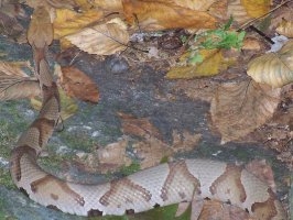
- Watch out for copperheads. They like rocks as much as
geocachers. Take a walking stick and poke around. Think I am
kidding? Here is one I nearly stepped on coming down the trail
after placing the cache:
- There are lots of slippery rocks after it rains. The way will
be more dangerous than it already is if you go after it has rained
(or while it is raining).
- I recommend against doing this cache if there is snow on the
mountain.
- This cache is not that far off the trail, but it is off the
trail. Let people know where you are going.
- See the geocaching.com disclaimer up there? Read it. Especially
the very first part where it says "Cache seekers [that includes
you] assume all [that means all] risks involved in seeking a
cache."
- Do this cache before Pogo
& Paula. This cache is harder to get to but it is easier to
find.

Additional Hints
(No hints available.)