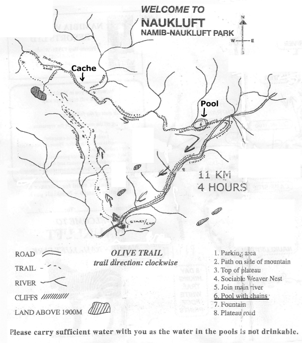
The cache is hidden on the Olive Trail in the rock wall about 3 m over the ground. It is not difficult to climb the wall (T2) but the Olive Trail itself isn´t easy (see below). The GPS-reception in the gorge is often bad so look at the spoiler pictures!
Olive Trail
The Olive Trail is a very nice trail at the Namib-Naukluft Park. The beautiful hiking trail starts near the Kudusrus Campsite in the Naukluft Mountains and follows a 11 km loop. At the beginning of the trail (where some olive trees are found) you start climbing a slope to the top of the mountain. Then you go down to a river bed following a beautiful gorge, where you will see some quiver trees. The difficulty but nonetheless highlight of the trail, is at the end of the gorge where you have to use a chain to cross a very narrow gorge with a deep pool.
Baboons, kudus and often rock dassies have been seen on the route. Hikers will need to carry enough water and food for the day, and remember to wear appropriate clothing for the time of year. This hike takes 4 to 5 hours and can be done all year (just follow the white footprints).
The entrance to the park is on Pad D854, about 9 km from the Buellsport turn-off from C14. The campsite is a natural camping ground without electricity or showers. There are 10 campsites. Food must be brought along.
Der Cache ist auf dem Olive Trail versteckt, in der Felswand, ca. 3 m über dem Grund. Es ist nicht schwierig, den Fels hinaufzuklettern (T2), aber der Olive Trail selbst ist nicht einfach (s. unten). Der GPS-Empfang ist in der Schlucht oft schlecht. Beachte deshalb die Spoilerbilder!
Olive Trail
Der Olive Trail ist ein sehr schöner Wanderweg im Namib-Naukluft Park. Der abwechslungsreiche Rundweg beginnt in der Nähe der Kudusrus Campsite in den Naukluft Bergen und ist 11 km lang. Am Beginn des Wanderwegs (dort stehen einige Olivenbäume) beginnt man mit dem Anstieg zum Hochplateau. Anschließend steigt man in einer schönen Schlucht wieder ab. In der Schlucht wachsen viele interessante Pflanzen z.B. Köcherbäume. Die Schwierigkeit aber auch ein Höhepunkt der Wanderung ist am Ende der Schlucht. Dort muss man eine Kette benutzen um in der engen Schlucht an der Felswand einen tiefen Wasserpool zu überklettern.
Auf der Tour wurden schon Paviane, Kudus und oft Klippschliefer gesehen. Denke daran, ausreichend Wasser und Lebensmittel für einen Tag mitzunehmen, sowie passende Kleidung für die Jahreszeit. Die Wanderung dauert 4 bis 5 Stunden und kann das gesamte Jahr über durchgeführt werden. Als Markierung dienen weiße Fußspuren, die auf die Felsen aufgemalt sind.
Der Eingang des Parks liegt an der D854, ca. 9 km von der Buellsportabzweigung von der C14 entfernt. Auf dem Campingplatz gibt es weder Duschen noch Elektrizität. Es gibt 10 Zeltplätze. Lebensmittel können nicht eingekauft werden.