>> Spanish below...
Introduction
This Earth Cache wants to take you to a wonderful spot where to
see and learn a bit about this sea between two continents. These
waters separate eastern Europe and western Asia. The Black Sea has
an area of 436,400 km2 and a maximum depth of 2,212 m (7,257
ft)
The Black Sea has a positive water balance; that is, a net
outflow of water through the Bosphorus and the Dardanelles into the
Aegean Sea and also receives river water from large Eurasian
fluvial systems to the north of the Sea.
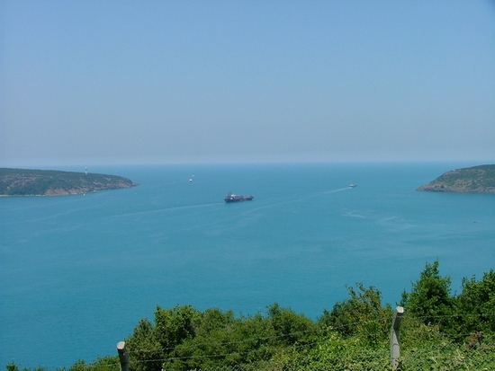
A great spot to see the gate to this sea is the Yoros Castle
(15th century , with parts of the 17th and 18th). Nowadays its
indoors access is closed due to archeological reasons and it is
unknow when it will be reopened.
From the Castle and because its great location, the landscape of
the Black Sea's gate as well as the Bosphorus sight is
terrific.
Some data about the Black Sea
There are several theories about the origin of its name,
'Black', the first can be because 'Kara (Black)' denotes 'North' in
Medieval Turkish, as in Kara Denizi- Kara Sea north of Siberian
Yakut Turks, similar to Black Sea. In Turkish 'Red' denotes south
as in Kizil Deniz, Red Sea to the south of Anatolia, while
'Ak'-White denotes west. Another explanation is because the Black
Sea is at the North-East of the Mediterranean. As a result, its
waters are much less salines and much more deep. Therefore the
concentration of micro-alga is quite large and all together makes
darker the water of the Black Sea.
The Black Sea is the world’s largest meromictic basin
where the deep waters do not mix with the upper layers of water
that receive oxygen from the atmosphere. As a result, over 90% of
the deeper Black Sea volume is anoxic water. The current
hydrochemical configuration is primarily controlled by basin
topography and fluvial inputs, which result in a strongly
stratified vertical structure and a positive water balance. The
upper layers are generally cooler, less dense and less salty than
the deeper waters, as they are fed by large fluvial systems,
whereas the deep waters originate from the warm, salty waters of
the Mediterranean. This influx of dense water from Mediterranean is
balanced by an outflow of fresher Black Sea surface-water into the
Marmara Sea, maintaining the stratification and salinity
levels.
Theories about the Mediterranean
connection
The Black Sea is connected to the World Ocean by a chain of two
shallow straits, the Dardanelles and the Bosphorus. The
Dardannelles is 55 m (180.45 ft) deep and the Bosphorus is as
shallow as 36 m (118.11 ft). By comparison, at the height of the
last Ice age, sea levels were more than 100 m (328.08 ft) lower
than they are now. There's also evidence that water levels in the
Black Sea, too, were considerably lower at some point during the
post-glacial period. Thus, for example, archeologists found
fresh-water snail shells and man-made structures in roughly 328
feet (100 m) of water off the Black Sea coast of modern Turkey.
Therefore it is agreed that the Black Sea has been a landlocked
freshwater lake (at least in upper layers) during the last
glaciation and for some time after.
In the aftermath of the Ice Age, water levels in the Black Sea and
the Aegean Sea rose independently until they were high enough to
exchange water. The exact timeline of this development is still
subject to debate. One possibility is that the Black Sea filled
first, with excess fresh water flowing over the Bosphorus sill and
eventually into the Mediterranean Sea. There are also catastrophic
scenarios, such as the "Black Sea deluge theory" put forward by
William Ryan and Walter Pitman.
Finally, In 1997, a hypothesis according to which a massive
flood through the Bosphorus occurred in ancient times is published.
They claim that the Black and Caspian Seas were vast freshwater
lakes, but then about 5600 BC, the Mediterranean spilled over a
rocky sill at the Bosphorus, creating the current communication
between the Black and Mediterranean Seas. Subsequent work has been
done both to support and to discredit this hypothesis, and
archaeologists still debate it. This has led some to associate this
catastrophe with prehistoric flood myths.
To log this Earth Cache
1) Climp up to the hill (15 minutes) where the
castle is. There is a wonderful view of the Black Sea's gate. Take
a picture there, with your GPS. Although this task it is not
mandatory is kindly requested for the EA's owner.
2) - As said above, the Black Sea is fed whith
water of one of the most famous rivers in Europe. Do you know which
one?
- The Black Sea is fed by the Bosphorus salt water as well, Do
you know how much km3 of salty water is feeding yearly the Black
Sea?
- Do you know how much km3 of RIVER water is feeding yearly the
Black Sea?
- Therefore, Is the Black Sea's water salty or not? Why?
- From the point of view of the salinity. Where is it easier to
float, In the Mediterranean or in the Black Sea? Why?
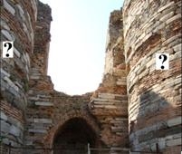
3) At the entrance of the Castle there are two
towers, There's a stone plaque on each one at 4m. with a drawing.
Can you describe the picture on the right tower? Is it the same
picture than the one on the left tower? If not, what is the
difference between them?
Introducción
Este Earth Cache quiere llevarte a un punto precioso donde
puedas observar y aprender un poco sobre este mar entre dos
continentes. El mar negro es un mar que separa la Europa Oriental
de la Asia Occidental. Tiene una superfície de 436.350 km² y una
profundidad máxima de2.214 m.
El mar Negro es inyectado anualmente por las aguas saladas que
provienen del Bósforo y a su vez por las aguas dulces de los rios
que en él desembocan. Un gran mirador para observar la puerta de
este mar es el Castillo de Yoros sel siglo XV, con partes del siglo
XVII-XVIII. Actualmente su acceso al interior está cerrado al
público por excavaciones arqueológicas y se desconoce si volverá a
ser abierto en breve.
Desde este Castillo y debido a su estratégica ubicación, la
visión del inicio del Mar Negro así como la vista hacia el Bósforo,
és realmente magnífica.
Algunos datos del Mar Negro
Hay varias teorías sobre el origen del nombre 'Negro' para este
mar, la primera puede ser una antigua asignación de colores a
los puntos cardinales: el negro es el Norte, el rojo el Sur y el
amarillo, el Este. Otra posible explicación viene del color de las
aguas profundas del mar Negro. Al estar más al norte que el mar
Mediterráneo y ser sus aguas mucho menos salinas, la concentración
de microalgas es mucho mayor, haciendo que el color de las aguas
sea oscuro.
La visibilidad en el mar Negro es aproximadamente de 5,5 m, en
comparación a un máximo de 35 m en el Mediterráneo. Hay una capa de
sulfuro de hidrógeno que empieza a unos 200 m por debajo de la
superficie, y es base de una población microbiana que produce
sedimentos negros, probablemente debido a la oxidación anaeróbica
del metano.
El mar Negro es la cuenca meromíctica más grande del mundo,
donde las aguas profundas no se mezclan con las capas superiores
del agua que reciben oxígeno de la atmósfera. Como resultado, más
del 90% de las aguas profundas del mar Negro tiene la
característica de ser agua sin oxigeno. Las capas superiores son en
general más frescas, menos densas y menos saladas que las aguas más
profundas, ya que son alimentadas por los grandes sistemas
fluviales, mientras que los fondos proceden de las aguas cálidas,
las aguas saladas del Mediterráneo. Esta afluencia de agua densa
del Mediterráneo es equilibrada por una salida del mar Negro de
agua superficial hacia el mar de Mármara, lo cual sirve para el
mantenimiento de la estratificación y los niveles de salinidad.
Teorías sobre la conexión con el Mar
Mediterraneo
Si bien se convino en que el mar Negro ha sido un lago de agua
dulce (al menos en las capas superiores) con un nivel
considerablemente más bajo durante la última glaciación, su
posterior desarrollo en un glaciar marino sigue siendo un tema de
intenso estudio y debate.
Diferentes teorías se basan en que el momento en que el mar
Mediterráneo era lo suficientemente elevado como para el flujo en
los Dardanelos y el Bósforo hizo que el mar Negro
deje de ser un lago. Por otra parte, un estudio del fondo marino en
el mar Egeo muestra que en el VIII milenio a.C. hubo un gran flujo
de agua dulce en el mar Negro.
En una serie de expediciones, un equipo de arqueólogos
identificó en lo que parecía ser la costa antigua, conchas de
caracol de agua dulce, los valles de los ríos se inundaron,
herramientas de trabajo de maderas y estructuras hechas por el
hombre en aproximadamente 91 m bajo el agua frente a la costa del
mar Negro de la Turquía moderna. La datación por radiocarbono de
restos de moluscos de agua dulce indica una edad de unos siete mil
años.
Por último, En 1997 se publicó una teoría según la cual en la
Antigüedad se produjo una gran inundación a través delñ Bósforo y
se afirma que el mar Negro y el mar Caspio fueron vastos lagos de
agua dulce, pero luego, sobre 5.600 a. C., el
Mediterráneo rompió el dique natural que lo separaba del lago
creando el paso actual entre los dos mares. Trabajos posteriores
que se han ido publicando han aportado argumentos tanto a favor
como en contra de esta teoría, y los arqueólogos aún debaten sobre
el tema. Esto ha llevado a algunos a asociar el Diluvio on esta
catástrofe prehistórica. William Ryan y Walter Pitman tiene un
libro sobre su teoría. Noah's Flood: The New Scientific
Discoveries About the Event That Changed History [Diluvio
de Noé: Los nuevos descubrimientos científicos sobre el
acontecimiento que cambió la Historia], publicado por Simon &
Schuster Paperbacks Nueva York, NY, 1998.
Para logar el cache
1) Sube al castillo (15 minutos) donde verás la
vista espectacular del mar negro, Allí hazte una foto con tu GPS.
Esta tarea no es obligatoria pero si que es gentilmente requerida
por el propietario.
2) - Como se ha dicho, el Mar Negro recibe agua
dulce de uno de los ríos más importantes de Europa, ¿Cual?
- También recibe agua salada desde el Bósforo, ¿Sabrias decir
cuantos km3 de agua dulce anual aportan los rios y cuantos km3
aporta el bosforo?
- En Consecuencia, ¿el Mar Negro es Dulce o Salado? ¿Puedes
justificar por que?
- Desde el punto de vista de la salinidad ¿Donde crees que se
flota mejor, en el mar Mediterráneo o en el mar Negro?. ¿Por
que?
3) En la entrada del castillo hay dos torres,
en cada una de ellas a unos 4m de altura hay una losa con un
dibujo. Describe el dibujo de la torre de la derecha.¿Es el mismo
dibujo que el dibujo de la torre izquierda? Si la respuesta es
negativa, ¿en que se diferencian?