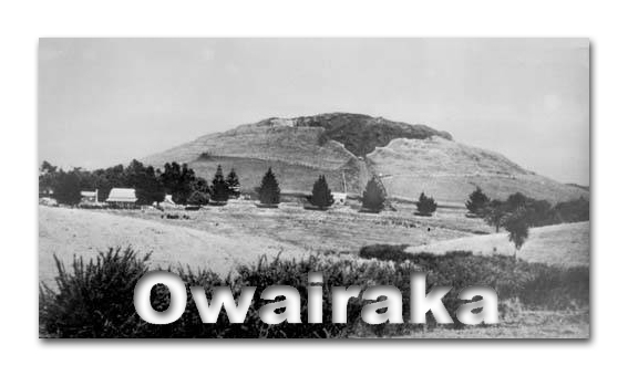
91011.5- Owairaka Mt Albert (Auckland) EarthCache
91011.5- Owairaka Mt Albert (Auckland)
-
Difficulty:
-

-
Terrain:
-

Size:  (not chosen)
Please note Use of geocaching.com services is subject to the terms and conditions
in our disclaimer.

The Auckland area, Tamaki-makau-rau (meaning ‘Tamaki of a
hundred lovers’) has a long history of Maori occupation. Due
to the significant number of tribes associated with
Tamaki-makau-rau and the almost constant warfare, tribal identities
were often complex with tribes emerging and disappearing into other
tribal groups. The volcanic cones had significant functional uses
in terms of defence and providing food on the fertile volcanic
soil. They became "important focal points at the hub of expansive
garden systems" (Cameron, Hayward & Murdoch 1997).
According to Maori legend, Owairaka was originally known as Te Puke
o Ruarangi (the hill of Ruarangi) after an incident where Ruarangi
and his people (descendant of the crew of the Tainui waka) were
besieged in their pa. They escaped the war party by entering a lava
cave on the south side of the mountain and following the
underground passage towards Western Springs. Upon reaching the sea,
they picked up lava rocks and threw them into the sea to form a
reef (Meola Reef) that allowed them to cross to the North
Shore.
Tainui sources apply the names Te Wai o Raka (‘the drinking
waters of Rakataura’) and Te Ahi Ka a Raka (‘the long
burning fire of Rakataura’) to the cone. Rakataura was the
leading tohunga on the Tainui canoe.
However, the best known Maori name for the mountain is Owairaka,
meaning the place ‘of or belonging to Wairaka’ or
‘the dwelling place of Wairaka’. Wairaka was a
Polynesian woman skilled in the sport of surfboard riding of which
her husband disapproved. A feud broke out between their families as
a result of his attempts to discourage her. Leaving her husband she
came to New Zealand from Tahiti on the Matatua canoe (one of the
main fleet landing at Aotearoa about 1350) with her father Toroa,
chief of the Ngati Awa and captain of the canoe.
The tribe landed at Whakatane and after settling there, Wairaka
entered into a dispute with her father over the selection of her
new husband. Leading a section of the tribe away, Wairaka moved
north to found a new community on the hill now known as Owairaka.
She eventually returned to Whakatane to join her people, leaving
some of her tribe on Owairaka.
The high cone of Owairaka was littered with loose pieces of scoria
when Europeans first began to settle in Mt Albert in the 1840's.
They used it for building walls, many of which remain around the
reserve and local gardens.
In 1867 a ballast pit was opened on Owairaka. The ballast pit was
an open quarry which supplied scoria to both local councils and
private citizens. In the 1880's the Auckland to kaipara railway was
extended and a Self Action Incline Tramway was constructed by New
Zealand Railways on the northern slopes of the mountain. The scoria
was used for building the railway line with the sleepers laid on
top of it.
Two trucks operated at a time on this tramway and ran on a single
track, with a twin tracked passing bay. The weight of the full
truck running down the slope pulled the empty truck up. They passed
each other at the passing bay. The tramway ran from a terminus
south of Mt Albert Road up the mountain on a slope of 1:25 and 1:3.
The track extended into the quarry where it divided into three
parallel track. A branch line transported scoria from Owairaka to
join the Auckland-Kaipara railway west of the Mt Albert Railway
Station.
The ballast pit operated for over 60 years, 1867-1928, and reduced
the height of Owairaka from its original 148m to 135m. Less than
half the original land surface of the domain remains and most of
the Maori terraces have been destroyed.
In the 1920's two reservoirs were built, one either side of the
entry by the Mt Albert Borough Concil. These are both now disused
and the northern one has been demolished. One of the craters was
levelled to form the football field while the other was used as the
site of the ARC reservoir which was built in 1945.
The floor of the ballast pit was flattened and has been used for
many years by the Mountain Green Archery Club. Further damage was
done to the remaining terraces when the inside face of the ballast
pit was smoothed in 1961. At the same time the Trig point was moved
from the rim of the ballast pit to its present position.
A small quarry operated from time to time during the 1950's and
60's. it was sited on the south-west corner of the mountain where
La Veta Avenue now is.
The heritage values of the mountain have been recognised more
recently and it is now protected as a Recreation Reserve under the
Reserves Act 1977. It is also a scheduled Archaeological and
Geological Feature listed in the Proposed District Plan 1993.
Aucklands Volcanoes
The Auckland volcanic field is a monogenetic volcanic field in the
North Island of New Zealand.
A monogenetic volcanic field is a volcanic field of small,
scattered volcanic vents. These volcanic fields, containing
numerous monogenetic volcanoes, are noted for having only one short
eruptive event at each volcano, as opposed to regular volcanoes
that have several eruptions from the same vent over a long period
in their history. Monogenetic fields occur only where the magma
supply to the volcano is low or where vents are not close enough or
large enough to develop plumbing systems for continuous feeding of
magma. Monogenetic volcanoes such as the ones in Auckland are
typically cinder cones.
Basaltic in nature, it underlies much of the metropolitan area of
Auckland. The field's many vents have produced a diverse array of
explosion craters, scoria cones, and lava flows. Currently dormant,
the field is likely to erupt again within the next "hundreds to
thousands of years" (based on past events), a very short timeframe
in geologic terms.
Maori mythology attributes the formation of Auckland's volcanoes to
a great battle fought between two forest dwelling peoples, who
lived in the Waitakere and Hunua ranges on opposite sides of the
volcanic field. As the battle raged, a tohunga from the Hunua side
caused the sun to rise early, which blinded their opponents and
allowed many of them to be killed.
The Hunua warriors then attempted to reach the Waitakere ranges to
finish the battle, but were stopped in their tracks by volcanic
explosions, lava and ash, invoked by the deity Mataoho at the
request of a Waitakere tohunga. The volcanoes that now dot the
Auckland landscape are said to be the remains of this volcanic
upheaval.
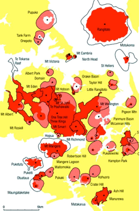
Where are the Volcanoes?

Maori and Volcanoes
Since soon after their arrival in Aotearoa, Maori chose to make the
Auckland district their home, settling close to many of Auckland's
volcanoes so they could utilise the rich, fertile soils for
gardening and take advantage of the steep sided volcanic cones as
defensive pa. The volcanic cones are believed to have) been used as
occupation sites from the 14th century and became increasingly
fortified from the 17th century on.
Evidence of past Maori activity can be seen at a number of
archaeological sites, including pa, terrace and food storage pits
on or near Auckland's volcanoes. For example, impressive and
complex earthworks of pa can be seen on cones like Maungawhau (Mt
Eden), Mangere Mountain and Maungakiekie (One Tree Hill). The final
development of such sites may have taken generations as all
earthmoving was done by hand, aided only by stone and wooden
tools.
Probably even more numerous than the pa are other earthworks
associated with dwelling places and food storage. They include;
terraces, which were built primarily as house sites, and were
later, developed for defensive purposes, platforms and numerous
types of pits.
Maori cleared large areas of volcanic stone to develop garden
plots. They shifted soil from exposed areas to artificially deepen
the garden soils. At Maungakiekie (One Tree Hill) it is estimated
that there were 1000 hectares of gardens on the extensive volcanic
soils surrounding the cone.
The rock cleared from the lava stone fields was used in several
ways. Stonewalls were built to mark the pathways through garden
systems or as housing foundations, which were rectangular with an
entranceway. Alternatively, volcanic rock was heaped up and covered
in soil, which then warmed up, enabling an extended growing season.
Other uses included row alignments, platforms, pavements,
sub-surface drainage systems, houses, shelters, stone-faced pits
and terraces, stone walled defences and retaining walls. Evidence
of these structures remains today, and can be seen in a number of
sites throughout Auckland. For example, stonewalls stretching up to
hundreds of metres can be seen on the stone fields of Puhinui near
Manukau City.
The Volcanoes of Auckland
| Albert Park |
Ash Hill |
Browns Island (Motukorea) |
| Cemetery Crater |
Crater Hill |
Duders Hill |
| Green Hill |
Hampton Park |
Hopua |
| Kohuora |
Lake Pupuke |
Little Rangitoto |
| Mangere Lagoon |
Mangere Mountain |
Matukutururu (Manurewa or Wiri Mountain) |
| Matukutureia (McLaughlin's Hill) |
Maungataketake (Ellett's Mount) |
McLennan Hills |
| Mount Albert (Owairaka) |
Mount Cambria |
Mount Eden (Maungawhau) |
| Mount Hobson (Remuwera) |
Mount Richmond |
Mount Roskill |
| Mount Saint John |
Mount Smart |
Mount Victoria |
| Mount Wellington (Maungarei) |
North Head (Maungauika) |
One Tree Hill (Maungakiekie) |
| Onepoto |
Orakei Basin |
Otara Hill |
| Otuataua |
Panmure Basin |
Pigeon Mountain |
| Pukaki Lagoon |
Pukeiti |
Pukekawa (Auckland Domain volcano) |
| Pukekiwiriki |
Puketutu Island |
Purchas Hill |
| Rangitoto Island |
Robertson Hill (Sturges Park) |
Saint Heliers (Glover Park) |
| Styaks Swamp |
Tank Farm ('Tuff Crater Lagoon') |
Table Cell |
| Taylor's Hill |
Te Pouhawaiki |
Three Kings |
|
Waitomokia (Gabriel Hill) |
|
To complete the EarthCahe please email the owner
the following:
1. What is the Geodetic Code (XXXX?) on the Land Information New
Zealand marker?
2. What are two sports that are played on the fields?
3. Name two types of Maori features that are visible?
4. From this location how many other of Auckland's volcanoes can
you see?
5. (optional) Take a photo of you or your GPS with a bit of
Auckland behind you and upload it with your log.
Thanks for visiting this Earthcache.
References:
GNS
Science
Science Learning Hub
Wikipedia
Auckland Regional Council
Additional Hints
(No hints available.)