|
|
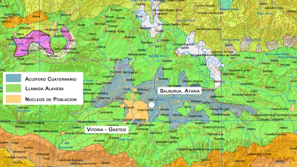
Vitoria-Gasteiz cuenta con las aguas subterráneas procedentes del Acuífero Cuaternario, de la Llanada Alavesa, formado por unos depósitos situados a ambos lados de la ciudad. Con una extensión de 90 km2 y un espesor medio de 5 metros, tiene unas reservas totales de 25 hm3 estimadas al comienzo de los periodos de estiaje.
La recarga de estos depósitos se realiza por la infiltración de las precipitaciones y de determinados arroyos y ríos en periodos de crecida, a los que se suman los retornos de riego.
Cuando estos depósitos se saturan, surgen encharcamientos naturales, explicación de los numerosos humedales que salpican la Llanada.
El de Salburua es el más conocido. Situado al este de la ciudad, está formado por varias lagunas (Arkaute y Betoño son las principales). Desecada siglos atrás para transformar la zona en campos de cultivo, los trabajos de recuperación iniciados en 1994 han revertido esta situación y en la actualidad Salburua es uno de los humedales continentales más valiosos del País Vasco y Humedal Ramsar de Importancia Internacional.
|
Vitoria-Gasteiz has groundwater from the Quaternary Aquifer of the Plains of Alava. It consists of a deposit on both sides of the city. With an area of 90 km2 and an average thickness of 5 meters, has total reserves of 25 hm3 estimated at the beginning of the periods of drought.
The recharge of these deposits is by infiltration of precipitation and some streams and rivers in flood periods, in addition to irrigation returns.
When these deposits are saturated, natural puddles occur, explaining the many wetlands that are in the Plains.
Salburua is best known. Located east of the city consists of several lakes (Betoño Arkaute and are the main ones). Dried centuries ago to transform the area into farmland, the restoration work started in 1994 have reversed this situation and now Salburua is one of the most valuable continental wetlands in the Basque Country and is a Ramsar Wetland of International Importance.
|
 |
La fluctuación en las reservas de agua en el acuífero a lo largo del año y, como consecuencia en el nivel del agua que se observa en las lagunas de Salburua es un proceso natural, que lejos de representar un problema para la fauna y la flora, es imprescindible para su normal funcionamiento.
Este ritmo de inundación queda reflejado en un periodo de estiaje veraniego en el que las balsas pueden llegar a secarse por completo, seguido de una época de máxima laminación que suele coincidir con los meses de enero y febrero.
|
Fluctuation in water reserves in the aquifer over the years and consequently the water level that is observed in the lagoons of Salburua is a natural process that far from being a problem for wildlife, is essential for normal functioning.
This rate of flooding is reflected in a summer drought period in which the rafts can become completely dry, followed by a period of maximum lamination that usually coincides with the months of January and February.
|
 |
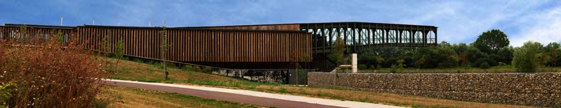
Ataria es el Centro de Interpretación del Humedal de Salburua y constituye sin duda uno de los rincones más singulares y emblemáticos del Anillo Verde de la Ciudad. Situado al norte del parque, Ataria es el principal punto de acceso al mismo y consta de un edificio y de un espacio exterior anexo.
En Ataria se puede profundizar en conocimiento de estos los humedales, sobre todo en su formación y en la importancia de su biodiversidad.
|
Ataria is the Wetland Interpretation Center of Salburua and is undoubtedly one of the most unique and iconic places in the Green Belt of the City. Located north of the park, Ataria is the main access point to it and has a building and an annex outer space.
Ataria can deepen understanding of these wetlands, especially in its creation and the importance of its biodiversity.
|
 |
El Anillo Verde de Vitoria Gasteiz es un conjunto de parques periurbanos de alto valor ecológico y paisajístico enlazados estratégicamente mediante corredores eco-recreativos.
En la actualidad, el Anillo Verde cuenta con 6 parques ya consolidados: Armentia, Olarizu, Zabalgana, Salburua, Alegría y Zadorra. No obstante, quedan todavía zonas pendientes de recuperación como Errekaleor o Lasarte, así como la conexión que enlazará unos espacios con otros a través de sendos corredores ecológicos.
El anillo forma una senda continua de 35 km que puede recorrerse a pie o en bicicleta. Para descubrirlo, existen una serie de cachés alrededor del mismo (este es uno de ellos). Pulsa en el plano para descargarte el Track del recorrido y en cada uno de los enlaces para acceder a las páginas de cada uno de los cachés. ¡A disfrutar!
|
The Green Belt of Vitoria Gasteiz is a set of suburban parks of high ecological and scenic corridors linked strategically through eco-recreation.
Currently, the Green Belt has 6 parks already established: Armentia Olarizu, Zabalgana, Salburua, Joy and Zadorra. However, there are still areas to be recovered as Errekaleor or Lasarte, as well as the connection link with other spaces through ecological corridors.
The Belt forms a continuous path of 35 km can be covered on foot or by bicycle. To discovered it, there are a number of caches around it (this is one of them). Click on the image to download the Track of the route and each of the links to the pages of each of the caches. Enjoy it!
|
|
|
| |
|
|
|
|
| |
Salburua |
Olárizu |
Armentia |
Zabalgana |
| |
|
|
|
|
| |
Ataria  |
Casa de la Dehesa  |
La Basílica |
La Atalaya |
| |
El Parque |
El Arboreto I |
El Bosque  |
El Bosque |
| |
Los Observatorios  |
El Arboreto II |
Alto del Molino |
Las Lagunas |
| |
|
|
|
Laguna de Lecea
|
| |
|
|
| |
Zadorra |
Alegría |
| |
|
|
|
|
| |
Puente Asteguieta |
Yacimiento de Atxa |
La Presa |
El Remanso |
| |
Ali - Gobeo |
Embarcadero Ortuona |
Gamarra |
La Campa |
| |
El Mirador |
Huertas de Urarte |
el Vasco-Navarro |
|
| |
|
Puente Abetxuko
|
|
|
|
|
| Fuentes: |
Centro de Estudios Ambientales (CEA) |
| |
Ayuntamiento de Vitoria Gasteiz (ATARIA) |
| |
Instituto Geológico y Minero de España (IGME) |
|
|
Para loguear este Earthcache, deberás acudir a Ataria y obtener información acerca de la formación del humedal de Salburua gracias al acuífero cuaternario de la llanada alavesa.
Después, deberás enviar un e-mail con las respuestas a las siguientes preguntas:
- Además de los expuestos a continuación, ¿de qué materiales se encuentra compuesto el subsuelo del acuífero cuaternario?
- Suelo
- Arcillas
- Gravas y Arenas
- Agua
- ¿X?
- ¿En qué mes del año se alcanza historicamente el nivel freático más alto del acuífero?. Aproximadamente, ¿qué altura máxima sobre el nivel del mar suele alcanzar?
- ¿Cuántas lagunas había en Salburua en 1857 cuando comenzó el intento de desecación del humedal?. ¿Cuales eran sus nombres y en qué orden desaparecieron?
- Aprovecha la ocasión. Sube a lo más alto de la pasarela. Ahí puedes, de forma voluntaria, hacerte una foto con tu GPS. Incluye esta foto en tu registro.
¡Atención!. No poner las respuestas en el registro del Earthcache. Sólo debes enviar las respuestas por e-mail.
|
To log this Earthcache, you must go to Ataria and get information about the formation of the Salburua wetland through the quaternary aquifer of the plains of Álava.
Then send us an e-mail with the answers to these questions:
- In addition to those set out below, what material is composed of the Quaternary Aquifer subsoil?
- Ground
- Clays
- Gravel and Sand
- Water
- X?
- In which month of the year is the aquifer freatic level historically higher?. Approximately what maximum height above sea level is usually achieved?
- How many lagoons were there in 1857 when it began the desiccation of the wetland?. What were their names and in which order disappeared them?
- Take advantage of the occasion. Climb to the top of the catwalk. There, you can voluntarily, take a picture with your GPS. Includ this photo into your log.
Attention. Don't put the answers in the Earthcache log. You only have to send your answers by e-mail.
|
|