AS#3 - Jättegrytor Traditional Geocache
-
Difficulty:
-

-
Terrain:
-

Size:  (small)
Please note Use of geocaching.com services is subject to the terms and conditions
in our disclaimer.
Välkommen till AS#3 - Jättegrytor!
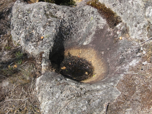
[SV]Denna cache är placerat en liten bit ifrån jättegrytor då det
finns en earthcache vid denna plats. En jättegryta är en
fördjupning i ett berg, bildat genom att strömmande vatten fått en
större sten tillsammans med grus och mindre stenar att rotera runt
i en virvel under lång tid under inlandsisen. Ofta har jättegrytor
påbörjats i en spricka eller där flera sprickor möts i
berggrunden.
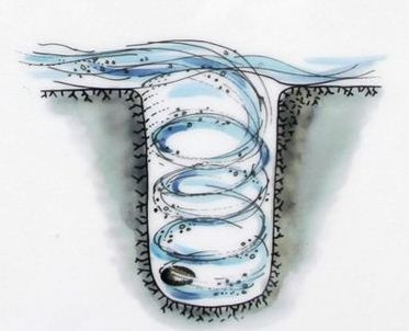
Många stora jättegrytor skapades under istiderna genom att en
större sten roterades med framforsande smältvatten tillsammans med
grus och mindre stenar längst ner mot glaciärens botten. Under
avsmältningsskedet rann rikligt med vatten på isen och i inälvar
under isen. När isen smälte bort rann enorma mängder vatten ner
genom sprickor och tunnlar i isen och både vattentrycket och
strömhastigheten kunde vara höga. Särskilt i svaghetszoner skedde
stora urholkningar. Ofta sattes block eller sten ("löpare") i
rotation i vattenströmmaen, förloppet fortsatte och grytan
svarvades ut. Jättegrytorna kunde bli upp till 20 meter djupa.
Stenen som har bidragit till jättegrytan ligger oftast kvar i
botten än i dag.
Jättegrytor vid Getaren räknas sannolikt tillhörande den
glacifluviala typen som bildats under inlandsisen. De ännu rätt
okända jättegrytor vid Getaren är jämfört med många andra
jättegrytor ganska små. För att hitta till grytorna följ
Äventyrsstigens blå markeringar. När man går från Lida så passerar
man en koja där stigen fortsätter rakt upp för en backe. När man
väl passerat backen finns det en skylt som pekar mot grytorna. Om
du följer skylten hittar du ett rep som tar dig upp till grytorna.
Det är också där waypointen finns.
[SV]Friluftsfrämjandets Äventyrsstig på ca 10 km har blå märkning
och går runt sjön Getaren. Stigen är ganska jobbigt och grova skor
samt matsäck rekommenderas. Hela rundan tar c:a 2-3 timmar beroende
på hur snabbt man promenerar, hur bra det går att hitta cacher samt
hur mycket man stannar för att njuta av naturen, utsikten, för att
krypa in i grottorna eller för att titta på djuren.
Det finns 8 stationer längs stigen. Vid varje station finns det en
cache. Det är bra att ha med sig papper, penna samt en liten
lampa.
Cacher som ingår i serien:
AS#1 - Vildmarksstuga (traditionell
cache); det finns lite andra cacher i närheten också,
AS#2 - Koja (multi cache),
AS#3 - Jättegrytor (traditionell
cache); passa på att även hitta earthcache Jättegryttor vid Getaren
som finns i närheten,
AS#4 - Kallkälla (traditionell
cache); ytterligare en cache finns närmare sjön,
AS#5 - Förkastningsgrotta (mystery
cache); bra att ha en liten lampa med sig här;
AS#6 - Norrga Kvarn (traditionell
cache); var försiktiga när ni passerar el-stängseln här;
AS#7 - Vindskydd (traditionell
cache); på vägen från Norgga Kvarn passeras en cache med jättefin
utsikt, glöm inte att ta den också;
AS#8 - Gömsle (multi cache).
Efter att ni hittat alla cacher är det dags för bonus cachen
AS - Bonus.
Welcome to AS#3 - Jättegryttor!
[EN] The cache is placed not right near the spot where the Giant´s
Kettles are but close to them because of the earthcache there. A
Giant's kettle, also known as giant's cauldron or pothole, is a
cavity or hole which appears to have been drilled in the
surrounding rocks by eddying currents of water bearing stones,
gravel and other detrital matter.
The interiors of potholes tend to be smooth and regular, unlike a
plunge pool.
They are three kinds of Giant´s Kettle´s: river pothole´s, beach
pothole´s and glacial pothole´s.
There is a myth which says that the potholes were made by giants,
long time ago, so that they could cook their food. That is how
potholes got their name.
These Giant´s Kettles near the lake Getaren are glacial potholess
which had probably been formed under inland ice. Strong rapid
flowing melt water set stones in rotation which excavate this
holes. These still quite unknown kettles are quite small.
To be able to find the potholes follow the blue markings of the
Adventure Trail. If you go from Lida then after you seen a small
hut follow the path up the hill. When you later on passed the hill
then you would come to a signpost which will show you the way to
the potholes. There is a rope which will help you upp whre you see
the holes. That is also where the waypoint is. Good luck!
[EN]Friluftsfrämjandets Adventure Path is about 10 km long and is
marked with blue colour. It is a nice walk around the lake Getaren.
The path is pretty demanding and that is why good shoes and a some
king of lunch are recommended. The entire round takes about 2-3
hours depending on how fast you walk, how quci can you find the
caches and how much you stop in order to enjoy nature or view, to
crawl into caves or to observe the animals.
There are eight stations along the trail. At each of these stations
there is a cache close to them. It is good to have a pice of paper,
pencil and a small lamp with you.
Caches included in the series:
AS#1 - Vildmarksstuga (traditional
Cache), there are some other geocaches nearby as well,
AS#2 - Koja (multi-cache),
AS#3 - Jättegrytor (traditional
cache), take the opportunity to find even the Earth cache
Jättegryttor vid Getaren which is nearby,
AS#4 - Kallkälla (traditional
cache), yet another cache which is closer to the lake,
AS#5 - Förkastningsgrotta (mystery
cache); good to have a small lamp with you here;
AS#6 - Norrga Kvarn (traditional
Cache); be carefull when you pass the electric fence here;
AS#7 - Vindskydd (traditional
Cache); on the way from Norgga Kvarn you will pass a cache with a
nice view, do not forget to take it as well;
AS#8 - Gömsle (multi-cache).
After you found all the caches, it is time for the bonus cache
AS - Bonus.
Källa: Wikipedia (en, sv), linkoping.se, www.lansstyrelsen.se,
jättegryttor.se
Additional Hints
(Decrypt)
1,7z