Svenska:
Beskrivning (efter
geologivägen och länstyreslsens
naturreservatsinformation):
Det mesta av det Svenksa landskapet har formats av glaciären under
istiden och 'Stockholmsgatorna' är ett enastående exempel till det.
Under istiden det fanns en stor issjö norr om området. Vid en
katastrofartad tappning av denna forsade vattnet fram genom dalen
och gröpte ur berget i en svaghetszon: kanjonen bildades. Vid flera
tillfällen tömdes andra sjöar i området också genom kanjonen som
blev djupare och djupare genom åren. Förutom kanjonen kan man se
vattnets inverkan genom slipad berg och det lösa materialet som
avlagrades söder om kanjonen.
Et annat fenomen som medföljer ofta glaciärens framfart över
landskapet är jättegrytor och de finns en del också här i
Stockholmsgatorna. Jättegrytor bildas genom att en stenblock, som
ligger på glaciären, börjar sjunker genom den. När den sjunker
bildas at hål i glaciären, der smältvatten störtar ner i kaskader
och sätter stenen i ett snurrande rörelse. När den hittar klipporna
och rakar vara hardare än dem, borrar stenen sig långsamt djupare
och djupare in i berget och därmed bildar själva jättegrytan (see
också Wikipedia:
Jättegryta).
När glaciären slutligen var borta efter istiden blev kanjonen
utsatt för dom vanliga naturkrafterna vind, vatten och frost som
ledde till att klippan började brytas ner och rasbrantor uppstod
som formade bland annat stora och djupa blockgrottor.
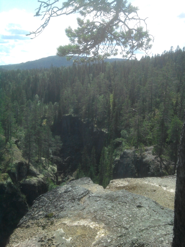
Idag är kanjonen ca 1,5 km lång med upp till 40 m höga lodräta
bergväggar. Det rinner an å genom kanjonen som gör bottnen fuktig
med små sjöar och moss som står i kontrast till dom torra klipporna
på kanjonens väggar.
Naturreservatet kan nås både från norr och söder via skogsbilvägar.
En markerad stig leder genom kanjonen, till den stora jättegrytan
och till fantastiska vyer från klipporna. På båda parkeringsplatser
finns informationstavlor och vindskydd.
Vandra stigen genom parken, titta ner från klipporna, ta en paus i
jättegrytan och besöka stora blockgrottan. Du skulle räkna med 2-3
timmer för det.
För att logga skicka svaren till mitt GC konto:
1. För hur många år sedan bildades kanjonen?
2. Hur stor är diametern till jättegrytan med rastplatsen (se
vägpunkten)?
3. Utgående från spiralerna i jättegrytans vägger, vad tror du hur
stor stenen som borrat den har varit?
4. I den stora blockgrottan är det så kallt att snön ligger kvar
aret runt för det mesta. Fanns det snö i grottan när du varit
där?
För att få logga måste du skicka svaren till min GC.com konto.
Efter du har skickat svaren får du logga direkt. Om de finns
anmärkningar beträffande dina svar kommer jag att kontakta
dig.
Jag skulle upskatta en foto på din favoritplats i området med dig
eller din GPS.
English:
Description (after
geologivägen and the county councils
naturreservatsinformation):
Most of the swedish landscape has been formed by the glaciers of
the ice age and "Stockholmsgatorna" (the streets of Stockholm) is
an exceptional example of that. During the ice age, there was a
large ice lake suited north of here. During a catastrophic drain
the water flushed through the valley and a small geological fault
was carved out: the canyon was formed. Several times other lakes in
the area were drained through the canyon as well and so the canyon
grew deeper and deeper. Besides the canyon the water left its marks
through grinded rock and the deposit of rubble south of the
canyon.
Another phenomenon that often arises when a glacier moves over the
landscape ar giant's kettles and there are several to be found
here. Giant's kettles are created by stones that lay on the surface
of a glacier and start sinking through it. A hole is created and
melting water, running down the hole in cacades, sets the stone
into a rotational movement. When the stone finally hits the rock at
the bottom of the glacier and is harder then it, it starts drilling
slowly deeper and deeper into the rock och the giant's kettle
arises (see Wikipedia:
moulin and Wikipedia: Giant's
kettle for more details).
After the glaciers finally melted at the end of the ice age, the
canyon was exposed to the eroding powers of wind, water and frost,
leading to the partial break down of the canyon walls and the
formation of debris cones containing large and deep rock
caves.
Today the canyon is about 1,5 km long and has up to 40 m high
vertical walls. A small river runs through the canyon leading to a
moist ground with small lakes and svamps, contrasting with the
dryness of the rocks on the canyon walls.
The nature reserve can be reached either from the north or the
south over small roads through the woods. A marked hiking trail
leads you through the canyon, to the largest glacier mill and
allows fantastic views from the cliffs. At both parking places
there are information panels and a shelter.
Follow the trail around the area, get a view from the cliffs, take
a break in the glacier mill and look down into the largest cave.
You should allocate 2-3 hours for that.
To log please send answers to the following questions to my GC
account:
1. How many years ago was the canyon formed?
2. How large is the diameter of the glacier mill with the resting
place at the northern end of the canyon (see waypoint)?
3. From the spiral carved into the walls of the mill, what is your
estimate how large the drilling rock was?
4. In the largest rock cave the temperature is so low, that there
is some snow normally all the year round. Was there snow in the
cave at the time of your visit?
In order to log this cache you have to send the answers to my
GC.com account. After sending them, you can log directly. If there
are issues regarding your answers I will contact you.
I would highly appreciate a photo with your favorite view and you
or your GPS.
Deutsch:
Beschreibung (nach
geologivägen und der
naturreservatsinformation des läns):
Der größte Teil der schwedischen Landschaft wurde von den
Eiszeitgletschern geformt und "Stockholmsgatorna" (die Gassen von
Stockholm) ist ein besonderes Beispiel dafür. Während der Eiszeit
befand sich ein nördlich von hier ein großer Eissee. Während einer
katastrophalen Entleerung desselben schoss eine große Flut durch
das Tal und grub sich an einer lokalen Schwächezone in den Fels:
Der Canyon enstand. Andere Seen in der Gegend entleerten sich in
der Folge öfters durch den Canyon und gruben ihn im Laufe der Jahre
tiefer und tiefer. Außer durch den Canyon kann man die Wirkung des
Wassers auch noch an den abgeschliffenen Felsen und den
Geröllablagerungen südlich der Mpndung des Canyons sehen.
Ein weiteres Phänomen das durch die sich fortbewegenden Gletscher
entsteht sind eine Reihe von Gletschermühlen. Diese Gletschermühlen
enstehen wenn Felsen, die auf dem Gletscher liegen, beginnen
langsam in diesen einzusinken. Dabei ensteht ein Loch, und durch
das hineinstürzende Schmelzwasser wird der Stein in Rotation
versetzt. Wenn dieser dann schließlich den Felsen unter dem
Gletscher trifft und härter ist als dieser, bohrt er sich tiefer
und tiefer hinein und bildet eine Gletschermühle (siehe auch
Wikipedia:
Gletschermühle und Wikipedia:
Gletschertopf).
Nachdem die Gletscher sich nach dem Ende der Eiszeit sich endgültig
zurückzogen war der Canyon den Naturkräften Wind, Wasser und Frost
ausgesetzt. Diese begannen die Felsklippen anzugreifen so dass sich
im Laufe der Zeit Schuttkegel bildeten, die teilweise große und
tiefe Felshöhlen bildeten.
Heute ist der Canyon ca. 1,5 km lang und hat bis zu 40 m hohe
senkrechte Felswände. ein schmaler Fluss durchfließt ihn, der den
Untergrund sehr feucht macht und damit einen deutlichen Gegensatz
zu den trockenen Felsklippen des Canyons bildet.
Das Naturreservat ist sowohl vom Norden als auch vom Süden aus über
Fahrwege erreichbar. Ein markierter Wanderweg erschließt sowohl den
Canyon als auch die größte Gletschermühle und bietet phantastische
Ausblicke von den Felswänden. An beiden Parkplätzen gibt es eine
Informationstafel und einen Windschutz.
Folge dem Weg durch das Gebiet, geniesse die Aussicht von der
Klippe, mach eine Pause in der Gletschermühle und betrachte die
größte Felsenhöhle. Man sollte für die Runde ca. 2-3 Stunden
einplanen.
Zum Loggen bitte die Antworten auf folgende Fragen an meinen
GC-Account schicken:
1. Vor wie vielen Jahren enstand der Canyon?
2. Wie groß ist die Gletschermühle mit dem Rastplatz am Nordende
des Canyons (siehe Wegpunkt)?
3. Ausgehend von den Spiralen in der Gletschermühlenwand, was
schätzt du, wie groß der Stein war, der die Mühle gebohrt
hat?
4. In der größten Felsenhöhle ist es so kühl, das sich dort Schnee
meist das ganze Jahr über hält. War dort Schnee, als du die Höhle
besucht hast?
Um diesen Cache zu loggen mußt du die Antworten an meinen GC.com
account schicken. Nachdem du sie geschickt hast, kannst du direkt
loggen. Wenn es Probleme mit den Antworten gibt, melde ich mich
dann schon.
Ich würde mich über ein Photo von deinem Lieblingsausblick incl.
dir oder deinem GPS freunen.