A Fall Line (or Fall Zone) is a narrow zone of transition between the Piedmont and the Coastal Plain and is so named because it marks the last appearance of bedrock waterfalls in river channels along the Atlantic Coast. Upstream from this point, river channels are rocky and straighter, with abundant rapids. Below the fall line, rivers tend to open up and bend gently back and forth as they flow over the coastal plain. From a geological perspective, it represents the contact between outcrops of crystalline Piedmont rocks (like granite) and the sedimentary deposits of the Coastal Plain.
In the United States, the fall line occurs between the Piedmont (the foothills of the Appalachian Mountains) and the Coastal Plain. The line stretches from New Jersey south along the coast to southeast Alabama, in some areas appearing as a cliff or escarpment, in other areas not as pronounced. The fall line is the ancient shoreline of the Atlantic Ocean (Mesozoic era -- the Age of Dinosaurs). It separates Upper Coastal Plain sedimentary rocks to the south from Piedmont crystalline rocks to the north.
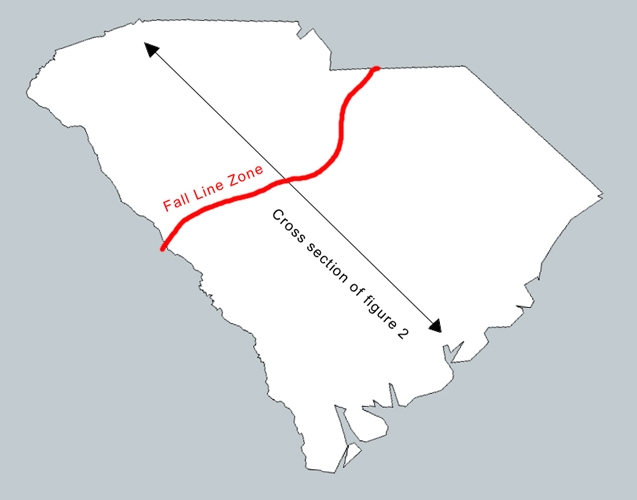
Here is a map view look at the Fall Zone, as it stretches parallel to the east coast dividing Piedmont from Coastal Plain. Notice that the Fall Zone runs right through the major cities of Richmond, Fredericksburg, Washington, Baltimore, Philadelphia, and New York. Why? Because these cities were all settled at the furthest-upstream navigable point on their respective river systems. Beyond the Fall Zone, boats start running into hard Piedmont rocks sticking up from the bottom of the river.

A fall line is typically prominent when crossed by a river, for there will often be rapids or waterfalls. Many times a fall line will recede upstream as the river cuts out the uphill dense material, often forming c-shaped waterfalls while in others it is a zone that may be many miles wide.
This modern fall line crosses the Congaree River just south of the Gervais Street Bridge. If you watch closely you can see the character of the river, geology, as well as the vegetation, begin to slowly change within a half-mile of the Gervais Street Bridge. The banks contain Coastal Plain vegetation starting just below the bridge, but there are outcrops of rock in the river channel down to just above the Cayce Landing. Historically the fall line marked the inland limit of major river travel, and is one of the main reasons for the location of the City of Columbia.
There are 3 waypoints listed. The 1st waypoint is at the top of the Fall Line, the 2nd is at the approximate point of the Fall Line and the 3rd waypoint is lower end of the Fall Line.
To log this cache you must –
#1 – Record the approximate elevation of the river at waypoints #2 & #3 listed.
#2 – Record the type of geology/sediment you see at all 3 waypoints listed (boulders, rocks, sand, etc) and then describe how they relate to their place in the fall line.
#3 – Describe how the river changes between all 3 waypoints in both flow, width and speed. How does the Fall Line effect this?
Please email all answers to the Cache Owner's Profile Email. Do not post them in your logs even if encrypted. You may also include a picture of yourself holding your GPS at the posted coords but it is not required.
 |
CONGRATULATIONS TO
KS&k on the FTF!! |
|
| I have earned GSA's highest level: |
 |