Jättegrytan i Skarpnäck EarthCache
-
Difficulty:
-

-
Terrain:
-
Size:  (other)
Please note Use of geocaching.com services is subject to the terms and conditions
in our disclaimer.
Jättegrytan i Skarpnäck
En jättegryta är en fördjupning i ett berg, bildat genom att strömmande vatten fått en större sten tillsammans med grus och mindre stenar att rotera runt i en virvel under lång tid. Många stora jättegrytor skapades under istiderna genom att en större sten roterades med framforsande smältvatten tillsammans med grus och mindre stenar längst ner mot glaciärens botten. Stenen som har bidragit till jättegrytan ligger oftast kvar i botten än i dag.
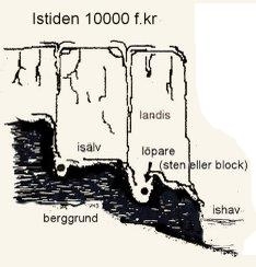 Under avsmältningsskedet rann rikligt med vatten på isen och i inälvar under isen. Smältvattnet på isytan letade sig ner i sprickor i isen och på grund av den stora fallhöjden kom vattnet i rotation och nådde berggrunden. Särskilt i svaghetszoner skedde stora urholkningar. Ofta sattes block eller sten ("löpare") i rotation i vattenströmmaen, förloppet fortsatte och grytan svarvades ut. Jättegrytorna kan bli upp till 20 meter djupa. Den här är däremot betydligt mycket mindre.
Det är inte helt ovanligt att man funnit gamla mynt i botten av jättegrytor, då det ansågs medföra god fiskelycka när man offrade ett mynt i en jättegryta.
Stockholmstraktens största jättegryta ligger 250 meter NV om Skarpnäcks gård. Grytan är väldigt lättillgänglig vid sidan av en cykelbana. Vid upptäckten år 1925 innehöll grytan ett 60-tal löpare, dvs rundslipade stenar, vilkas diameter varierade mellan 0,5 och 3 dm. Tyvärr är anslagstavlan som i korthet beskrev grytans bildningssätt nu borta.
För att logga denna Earthcache ska du svara på följande frågor.
1. Hur stor uppskattar du att denna jättegryta är?
2. Vilken form har jättegrytan och varför tror du den har fått just den formen?
Bifoga gärna en bild på hur du mätt grytan.
Skicka svaren till Granatherna.
OBS! Du behöver inte invänta ett svar innan du loggar.
Skriv inga svar i loggarna!
Giant Pot in Skarpnäck
A pothole is a depression in a rock, formed by flowing water with a large stone with gravel and small stones to rotate around in a vortex for a long time. Many large potholes were created during the ice ages by a large stone rotating with the rushing melt water along with gravel and small stones at the bottom of the glacier bottom. The stone that has contributed to the pot can sometimes still be found in the bottom of the hole.
During the melting stage, large amounts of water flowed under the ice. The melting water on flowed down into the cracks in the ice, and because of the large vertical drop water came into rotation when reaching the rock. Blocks or stone ("runners") started rotating in the stream and the kettle was milled out. Potholes can grow to 20 meters deep. This is however much less.
Stockholm's largest pothole is located 250 meters NW of Skarpnäcks yard. The pothole is very accessible at the side of a cycle path. At the discovery 1925 the pot contained about 60 runners, ie, polished stones, whose diameter ranged from 0.5 to 3 dm. Unfortunately, the bulletin board which briefly described the upcoming of the pan is now gone.
To log this Earth Cache, please answer the following questions.
1. How large do you estimate that this pothole is?
2. What form does the pot have, and why do you think it has that particular shape?
Please include a picture of how you measured the pot (optional).
Send your answers to Granatherna.
NOTE: You do not need to wait for a response before logging.
Please do not reply in the logs!
Additional Hints
(No hints available.)