FRANCAIS
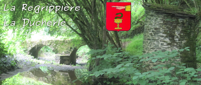
La Ducherie était jadis traversée par une voie
romaine. Il en subsiste encore un barrage, recouvert maintenant par
les eaux et la mousse, et un pont, encore visible. En juillet 1828
la Duchesse de Berry désireuse de boire un bol de lait dans une
ferme, fit halte en ce ravin ravissant. Il lui restait des fonds à
distribuer pour le département qu'elle quittait. Elle en aurait
rempli - dit la tradition - une soupière, et les paysans qui firent
la découverte furent heureux et surpris.
Informations complémentaires :
- Distance totale du parcours : 2,985 km
- Le parcours peut être inondé en hiver et par temps de
pluie.
- Le parcours peut être glissant lorsque le sol est humide et
lorsque les feuilles d'arbres sont au sol.
- Des herbes hautes peuvent être présentes sur une partie du
parcours, habillez-vous avec une tenue adéquate.
- Une partie du parcours emprunte la route D756, faites très
attention à la circulation.
Garez-vous au WP1 (N47°10.858' W1°10.593')
correspondant au parking.
Dirigez-vous vers le WP2 (N47°10.940' W1°10.490')
en empruntant la rue descendante située entre la poste et l'église.
Dans cette rue vous apercevrez une maison comportant une
inscription sous la forme "P-S xxxx" au-dessus d'une porte. Soient
A,B,C et D les chiffres correspondants à la date xxxx.
Au WP2, dirigez-vous vers le WP3 (N47°10.823'
W1°10.213') en prenant à droite et en suivant la rue des Carrières.
Vous devrez apercevoir, sur la droite, un premier panneau rouge à
texte blanc. Soit E le chiffre correspondant au nombre total de
mots inscrits sur ce panneau. En continuant vous devrez voir un
deuxième panneau identique.
Au WP3, vous serez entouré de deux panneaux en bois
:
- Le premier indique "La Sangèze -> x.xxx km". Soit F le
chiffre correspondant au nombre de kilomètres x.xxx multiplié par
10.
- Le deuxième indique "x.xxx km <- La Regrippière bourg". Soit
G le chiffre correspondant au nombre de kilomètres x.xxx multiplié
par 10.
Dirigez-vous vers le WP4 (N47°10.894' W1°09.902').
Il n'y a rien à trouver jusqu'au WP5.
Dirigez-vous vers le WP5 (N47°10.760' W1°09.884').
Avertissement : à l'automne, le sol peut-être recouvert de feuilles
et donc être glissant. Vous devriez apercevoir le pont.
Au WP5, vous êtes devant un panneau explicatif.
Soit H le chiffre correspondant au nombre total de mots en gros
caractères écrits en bleu.
Dirigez-vous vers le WP6 (N47°10.720' W1°09.804').
Avertissement : la partie la plus dure du parcours vous attend,
faites très attention lors de la montée et lors la descente des
marches. Ensuite des herbes hautes peuvent vous attendre jusqu'au
WP8.
Au WP6, vous arrivez au bord d'une route
départementale. Avertissement : faites attention à la circulation
jusqu'au WP7. Vous pouvez voir un panneau marron et un autre bleu.
Choisissez la bonne affirmation parmi les possibilités suivantes
:
- Le panneau bleu indique "Bienvenue en vignoble touristique".
I=2
- Le panneau bleu indique "Bienvenue en Loire Atlantique".
I=5
- Le panneau bleu indique "Bienvenue en Bretagne historique".
I=8
Ensuite longez la route jusqu'au WP7 (N47°10.695'
W1°09.881').
Au WP7, tourner à droite en empruntant le chemin
fléché en jaune remontant vers les vignes pour aller au WP8
(N47°10.697' W1°09.995').
Au WP8, vous avez bien mérité une pause pour
calculer l'emplacement de la cache. Faites les calculs suivants
:
- W = H-A
- X = I-E
- Y = D/2
- Z = B-F
Les coordonnées sont :
N 47°10,WXY'
W 001°10,CZG'
Vous pouvez aller au WP9 qui correspond à l'endroit
de la cache. Ensuite vous retrouverez le chemin du retour en
tournant à gauche.
ENGLISH
The Ducherie was once crossed by a Roman road.
It is still a dam, now covered by water and foam, and a bridge,
still visible. In July 1828 the Duchesse de Berry willing to drink
a bowl of milk on a farm, stopped in this lovely ravine. He still
had money to distribute to the department that she was leaving. She
would have filled - tradition says - a soup bowl, and the peasants
who made the discovery were happy and surprised.
Further information :
- Trail total distance : 2,985 kilometers
- The trail can be flooded in winter and rainy
weather.
- The trail can be slippery when soil is moist and when the
tree leaves are ground.
- Tall grass may be present on a portion of the course, dress
up an outfit with adequate.
- A portion of the trail follows the D756 road, pay close
attention to traffic.
Park at WP1 (N47°10.858' W1°10.593')
corresponding to the parking.
Go to WP2 (N47°10.940' W1°10.490') by taking
down the street between the post station and the church. In this
street you will see a house with an inscription in the form "P-S
xxxx" above a door. Let A, B, C and D the corresponding numbers of
the date xxxx.
At WP2, go to WP3 (N47°10.823' W1°10.213') by
turning right along the road "rue des Carrières". You will see, on
the right, a first red panel whith white text. E is the number for
the total number of words on this panel. By continuing you will see
a second identical panel.
At WP3, you will be surrounded by two wooden
panels :
- The first one indicates "La Sangèze -> x.xxx km". F is
the number of x.xxx kilometers multiplied by 10.
- The second one indicates "x.xxx km <- La Regrippière
bourg". G is the number of x.xxx kilometers multiplied by
10.
Go to WP4 (N47°10.894' W1°09.902'). There is
nothing to found until WP5.
Go to WP5 (N47°10.760' W1°09.884'). Warning :
during autumn, the ground can be covered with leaves and be
slippery. You should see the bridge.
At WP5, you are in front of a display panel. H
is the number corresponding to the total number of words written in
large letters in blue.
Go to WP6 (N47°10.720' W1°09.804'). Warning :
The hardest part of the trail waiting for you, be careful when
climbing and descending in steps. Then the tall grass can be
present until WP8.
At WP6, you get to the edge of a departmental
road. Warning : be careful to traffic until WP7. You can see a
brown sign and a blue. Choose the correct statement among the
following options :
- The blue sign indicates "Bienvenue en vignoble touristique".
I=2
- The blue sign indicates "Bienvenue en Loire Atlantique".
I=5
- The blue sign indicates "Bienvenue en Bretagne historique".
I=8
Then walk along the road to WP7 (N47°10.695'
W1°09.881').
At WP7, turn right taking the path indicated by
a yellow arrow, you will be in the vineyards to go to WP8
(N47°10.697' W1°09.995').
At WP8, you have earned a break to calculate the
location of the cache. Make the following calculations :
- W = H-A
- X = I-E
- Y = D/2
- Z = B-F
The coordinates are :
N 47°10,WXY'
W 001°10,CZG'
You can go to WP9 which corresponds to the
location of the cache. Then you will find the way back by turning
left.

Le nouveau forum du Geocaching en France