One day Signal the Frog decided he wanted to go out and discover his nature side so he planned a trip to Idaho. His plan was to discover elk, deer, moose, coyotes, birds, and maybe a wolf while hiking the woods. He wanted to see Cedar, Red Fir, Ponderosa Pine, small flowers, wild strawberries, maybe even some huckleberries or thimbleberries too. His journey, he knows, will also take him near some small ponds, and some marshy areas. What more could a frog desire?
Signal the Frog left behind a trail of crumbs for geocachers to follow while visiting Idaho. All geocaches are the preformed pop bottles with white caps.
Come Prepared:
- Bring food and water. This journey will take a day or two to finish depending upon your mode of travel – foot or ATV or motor bike. The area is riddle with many old logging roads and 4 wheeler trails.
- Wear good boots. The area has been logged so there are lots of branches on the ground. A bad winter has blown over many trees that you will have to cross.
- Let someone know where you will be – THERE IS NO CELL PHONE SERVICE.
- Park your rigs off the shoulder of the road. There are plenty of places along the road to park.
- Nearest towns are Orofino ID and Pierce ID. You can get gas, food and shelter there. Dent Acres Campground on Dworshak Reservoir is also close by.
- During hunting season – wear bright colored clothing.
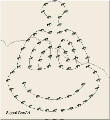
This GeoArt consists of 70 caches laid out in the shape of Signal’s face. It is not an easy dash and grab type of caching. It is NOT a power trail. It is designed for the hardy geocacher. You will be hiking along skid trails, old logging roads, up hill and down hill over and over again. The elevation ranges from 3052 to 3400 ft. Take your time and enjoy the hike. Most caches are 200 to 300 ft off logging roads not accessible with your georig. Sometimes the tall trees cause bad reception on the gps’r. Each cache will have a specific hint since we want you to find them all. Some will have a trailhead waypoint to help you or a spoiler picture.
This series of caches is placed with permission from Idaho Department of Lands. It not be accessible during the winter as there is too much snow in this area. Depending on the year, you should be able to access the caches from May through November.
********************Additional Info**************
- #11 - Picture. This one has thorns. Approach from East is best way to get to it.
- #37 - Picture
- #’s 40 & #41 -There is a creek between them, you will be able to find away across. If walking you can cross at the south end of pond. If 4wheeling, you can also cross south end but further down.
- #58 – Spoiler Picture and Additional Waypoint
- #59 – Spoiler Picture and Additional Waypoint
- #64 – Waypoint for 4Wheeler Trail
- #68 – Waypoint for Motorbike Trail & Spoiler Picture
**************************************************
The cache owners are not responsible for any injuries or accidents occurred while doing this cache. Take your time and enjoy yourselves!