H2SO4 - አሲድነት ሐይቅ - ACIDIC LAKE! EarthCache
H2SO4 - አሲድነት ሐይቅ - ACIDIC LAKE!
-
Difficulty:
-

-
Terrain:
-

Size:  (other)
Please note Use of geocaching.com services is subject to the terms and conditions
in our disclaimer.
እኛ በመሆኑ ለማመን ልዩ ልዩን አወቃቀር በእርግጥ ልዩ የሆነ ቦታ ይሄዳሉ . ይህ ቢሆንም እዚያ ማግኘት ከባድ የሚያስገርም ነው . በኢትዮጵያ ሰሜን ምስራቅ ውስጥ ደንከል በረሃ ውስጥ የዳሎል አካባቢ በሌሎች ተመጣጣኝ ያለ ግዙፍ የተፈጥሮ የኋለኞች ያቀርባል . ስለ -120m አንድ ከፍታ ላይ መሆን ስፍራውን በሙሉ በደንብ ከባሕር ወለል በታች ነው . ስለዚህ ስለ ወገብ ላይ ያለው ቅርበት እኛ በፕላኔታችን ላይ ሞቃታማ ቦታ ላይ ናቸው . ይህ 35 ° ሴ ወይም 95 ° ፋ አንድ ዓመታዊ አጠቃላይ አማካይ ተሞክሮዎች . ናቸው በጣም ወደር የሌለው እንዲሆን ምን ብዙ - ቀለም ባህሪያት እኛ , በዚህ አካባቢ ውስጥ ወዲያና ወዲህ ሲመላለሱ ከተመለከቱ ግራ የሚያጋባ ዓለት እንዲለማ , የሰልፈሪክ ጋዞች ከፍተኛ መጠን መልቀቅ ሐይቆችና ሙሉ በሙሉ ዝርግ ጨው አውሮፕላኖች .
We are going to a place which is really unique because of its unbelievably manifold structure. It is extraordinary tough to get there though.
The Dallol area in the Danakil desert in the Northeast of Ethiopia presents a massive natural spectacle without an equivalent elsewhere.
The whole place being at an elevation of about -120m is well below sea level. Therefore and because of its proximity to the equator we are at the hottest spot of our planet. It experiences a yearly overall average of 35 °C or 95 °F. What does make it so unparalleled are
the many-coloured features we observe walking around in this environment,
bizarre rock formations,
lakes releasing huge amounts of sulphuric gases and
totally flat salt planes.
እኛ ቀናት እና ርቀት አህጉራት ቅርጽ ቀስ በቀስ አሁንም እየቀጠለ ነው ስለዚህ ባለፉት 150 ሚሊዮን ዓመት አሂድ ወይም በጓደኛህ ምክንያት የሆነ ሁኔታ ላይ መሆኑን ያውቁ ዘንድ. እኛ ለምሳሌ እኛ የዓለምን ካርታ ሲመለከቱ ከሆነ መሆኑን ለማየት እና በደቡብ አሜሪካ እና የአፍሪካ ጠረፎች አብረው ለማስማማት ምን ያህል ማወቅ ይችላል. እነዚህ ነጠላ ጥንታዊ አህጉር "Pangea" (1) ከ የመነጩ. እኛ የምሥራቅ አፍሪካ ስምጥ ሸለቆ ዳርቻ እንዲህ ያለ መለያየት መመልከት ይችላሉ. ይህ ሁሉ መንገድ Moçambique ወረደ ከሶርያ የመጡ አንዳንድ 6000 ኪሎ ሜትር ያህል ይዘረጋል. ይህ ምክንያት tectonic ቁጥሮን ከመቀያየር ምድር በብዙኃኑ ውሎ አድሮ አዲስ አህጉር ቅርፆች ፈጠረ እየተራራቁ የት ይህ መስመር ነው. እንቅስቃሴ እኛ በቀጥታ መመልከት አትችሉም በጣም የረቀቀ ነው. ይሁን እንጂ, አንዳንድ ማስረጃዎች ማጥናት እንችላለን. ምክንያት የዳሎል አካባቢ ላይ ላዩን ወደ ፈሳሽ የቀለጠ ድንጋይ ያለውን ቅርበት ወደ ላይ መሄድ በእሳተ ገሞራ እንቅስቃሴዎች አሉ. እሳተ ገሞራ የ መሬት እና ሌሎች ፕላኔቶች ውሎ አድሮ ወደ ታች ይቀዘቅዛል መንገድ መረዳት ይቻላል. እሳተ ገሞራ አይነቶች ምሳሌዎች ናቸው ሀ) የመትነን የኮን ገሞራ. ቅልጥ እንዲከፍል ጋዝ ወደ ውጭ በሚነፋ ነው. ይህ በጣም ፍጹም ቅርጽ አንድ ሾጣጣ ያበጃል. ለ) የተውጣጣ ገሞራ ቅልጥ ቦይ አገናኝተዋል. ፈሳሽ ቅልጥ ይመስላል ሳይሆን ጠንካራ ዐለት ቁሳዊ ወደ ውጭ ይጣላል. ቅልጥ ላይ ላዩን ይመጣል የት ታች የሚፈሰው ውሎ አድሮ አስቸጋሪ ይሆናል. የተለያዩ ክፍሎች ያሉት እሳተ ገሞራዎች ያላቸውን የሚተካከለው ውስጥ ማዕከላዊ ሊቀደድ ያላቸው እና አንዳንድ ጎን በጣም ሊወጣባቸው. ሐ) ሺልድ ገሞራ በሙሉ ማለት ይቻላል, ሁሉም አቅጣጫዎች ውስጥ ሲፈስ በከፍተኛ ፈሳሽ ቅልጥ የተገነባ ነው. በመሆኑም ወለል እንደ ጋሻ ነው የተገነባው. መ) ፍንዳታ እንዳስቆጠሩ. በሆነ ምክንያት ከፍተኛ ግፊት ድንገት ነው የተገነባው. ይህ አንድ ትልቅ ፍንዳታ ያስከትላል. ቅርጽ የተለየ ሊሆን ይችላል. ውኃ አንድ ትልቅ መጠን ከመሬት በታች በጣም ሞቃት ፈሳሽ የቀለጠ ድንጋይ ጋር ግንኙነት ወደ ጊዜ የዳሎል እሳተ ገሞራ መጀመሪያ ባለፈው ክፍለ ዘመን የተሰራ ነው. የ ፈሳሽ የቀለጠ ድንጋይ ሩቅ በላይ 900 ° ሴ ወይም 1600 ° F በግምት ሙቀት ተፈጥሮ ሊሆን ይችላል. ውሃው በቅጽበት ከፍተኛ ግፊት ለማነጽ እየተጋችሁ ይተናል. ግዙፍ ልኬቶች (phreatic ፍንዳታ) እኛም እስከ አሁን ድረስ ምስክር ይችላሉ በውስጡ እንቅስቃሴዎች ጋር እሳተ ገሞራ ተቋቋመ አንድ ፍንዳታ ይህ ግንባር.
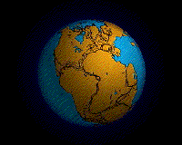 We might know that the shape of the continents of our days and their distances are in a status that is a result of slowly drifting apart in the run of the last 150 million years or so which is still continuing. We can see that for example if we are looking at a world map and recognize how well the South American and African coastlines fit together. They originate from the single ancient continent "Pangea" (1).
We can observe such a separation along the East African Rift Valley. It stretches out for some 6000 km from Syria all the way down to Moçambique. It is along this line where the land masses due to shifting of tectonic plates eventually drift apart forming new continental shapes. The movement is so subtle that we cannot observe it directly. However, we can study some evidence. Due to the proximity of the magma to the surface in the Dallol area there are volcanic activities going on.
Volcanoes can be understood as a way the Earth and other planets eventually cool down. Examples of volcano types are
a) Cinder Cone Volcanoes. Gas charged lava is blown out. It forms a cone of a quite perfect shape.
b) Composite Volcanoes have linked lava conduits. Liquid lava appears but also solid rock material is thrown out. Where lava comes to the surface it flows down and solidifies eventually. Composite Volcanoes have a central vent in their crater and some side vents too.
c) Shield Volcanoes are almost totally built by highly liquid lava flowing into all directions. Thus a shield like surface is built.
d) Explosion Craters. For some reason high pressure is abruptly built. It results in an immense explosion. The shape can be different.
The Dallol Volcano was built early last century when a big amount of water came into contact with very hot magma below the ground. The magma might have had an estimated temperature of far above 900 °C or 1600 °F. The water instantly evaporated building up an enormous pressure.  This lead to an explosion of gigantic dimensions (phreatic eruption) and formed the volcano with its activities we can witness until now.
እኛ መርዛማ ጉሮሮ የማይሉ ጋዞች ታመነጫለች አንድ ቀለም ሐይቅ ብቅ የተለያዩ ቅርጾች እና መልኮቹ የሚያስደምም ነው እንዲለማ ያያሉ ወደ ጣቢያው የሚመጣ . ስለዚህ የእኛን አፍንጫ ፊት ለፊት መያዝ ዝግጁ ቢያንስ አንድ እርጥብ ጨርቅ እንዲኖራቸው ጥበብ ይሆናል .Coming to the site we will see awe inspiring formations of different shapes and hues protruding of a coloured lake that emits toxic throat irritating gases. Therefore it will be wise to have at least a moist cloth ready to hold in front of our nose.
ምን እንዳጋጠመው እሳተ ሰልፈር ዳይኦክሳይድ የሚያቀርብ ነው(SO2).ምክንያቱም አብረው መሰረት sulphurous አሲድ ያፈራላቸዋል የጥልቁ የሚያጣብቅ እና ምራቅ ጋር ሰውነታችን ያናድደኛል
SO2(g)+H2O(l)⇌H2SO3(l).
ተመሳሳይ ሂደት እርጥብ ጨርቅ ውስጥ ቦታ ይወስዳል . በመሆኑም በእኛ አፍንጫ እና ጉሮሮ ያድናል . ይህም ደግሞ እጅግ ተለቅ እኛ ትኩር ሐይቁ ውስጥ መጠን እና የት እኛ ደግሞ ጥቃቅን ማስተንፈሻዎች ከ ላለመወጣት ትነት መመልከት ይችላሉ እንሆናለን .የ sulphurous ሲድ አየር ግንኙነት ውሎ አድሮ መሠረት የሰልፈሪክ አሲድ ወደ oxidized ነውየሰልፈሪክ አሲድ በማጎሪያ ምክንያት መሰረት በተግባር ጠቅላላ dissociation ( ከዓመታዊ ) ወደ አንድ የመኪና ባትሪ ውስጥ እጅግ ዝቅተኛ ቢሆንም
2H2SO3(l)+O2(g)⇌H2SO4(l).
H2O(l)+H2SO4(l)⇌H3O+(aq)+HSO4-(aq)
የ ፒኤች ይህ Hydronium በጣም ከፍተኛ የሆነ ትኩረት ነው ማለት ነው 1. ያነሰ ነው (H3O+)-ionsወደ አሲድነት ውጤት እንዲፈጠር ናቸው . በመሆኑም የእኛን አካል ጋር ግንኙነት መግባት የለባቸውም ይህም ይልቅ ጠበኛ ፈሳሽ ነው . ይሁን እንጂ በጣም መጠንቀቅ እኛ ወደ አምላካችን ሩቅ fingertip ነክሮ መላሴን ይችላል እና በጥንቃቄ ቅመሱ .
ሐይቁ ቀለም የበደልን የተለያዩ ማዕድናት አየኖች ( በኤሌክትሪክ ክስ ቅንጣቶች ) ምክንያት ነው . ይዘቶችን ምርመራ መደረግ ገና አለን . አጋጣሚዎች የመዳብ ( ያደላ ወይም አረንጓዴ ) , ብረት ( አረንጓዴ ወይም ፀጉራቸው ) , ማንጋኒዝ (ለምሳሌ ሐምራዊ ) ሊሆን ይችላል.
What happens is that the volcano dispenses sulphur dioxide (SO2). It irritates our body because together with the watery mucus and saliva it formes sulphurous acid as per
SO2(g)+H2O(l)⇌H2SO3(l).
The same process will take place in the moist cloth. Thus it will save our nose and throat. This also happens to a far larger extent in the lake we gaze at and where we can also watch vapour evading from tiny vents. By contact to air the sulphurous acid is eventually oxidized to sulphuric acid as per
2H2SO3(l)+O2(g)⇌H2SO4(l).
Although the concentration of sulphuric acid is by far lower than in a car battery, due to the practically total dissociation (disaggregation) as per
H2O(l)+H2SO4(l)⇌H3O+(aq)+HSO4-(aq)
the pH is lower than 1. It means that there is an extremely high concentration of Hydronium (H3O+)-ions which are causing the acidic effect. Thus it is a rather aggressive liquid which must not get into contact with our body. However, being very careful we could dip our furthest fingertip into it and cautiously taste.
The colour of the lake is presumably caused by ions (electrically charged particles) of different metals. The contents have yet to be examined. Possibilities could be copper (bluish or greenish), iron (greenish or brownish), manganese (e.g. violet).
እነዚህ ሁሉ ማብራሪያዎች በኋላ እኛ ቀለማት በዚህ አስደናቂ ሲምፎኒ ውስጥ endulge ትፈልግ ይሆናል .
አንተ አሉ አንዴ ምናልባት እንደ በሃ ድንጋይ እንዲለማ , አንድ ከፈላ ሐይቅ እና ሰፊ ጨው ሜዳ ውስጥ አንዳንድ ኮረብቶች ደግሞ እንደ ዙሪያ ሌሎች ክስተቶች መመልከት ትፈልጋለህ . የአጋጣሚ ነገር ሆኖ አንተ በራስህ ላይ ይህን ማድረግ አይችልም . በመኪና ወደዚያ ሊወሰድ እና በአካባቢው መመሪያ ማስያዝ አለባቸው.
After all these explanations we might like to endulge in this magnificent symphony of colours.
Once you are there you would probably like to explore also the other phenomena around such as the limestone formations, a boiling lake and some hills in the wide salt plain. Unfortunately you cannot do this on your own. You have to be taken there by car and be accompanied by a local guide.
ይህ ልዩ ቦታ መሆኑን ይገንዘቡ እባክዎ ! ማንኛውም መዋቅሮች ሊያጠፋ እና ጠርሙሶች እና ሌሎች ቆሻሻ ወደ ኋላ እንዳትወስድ ተጠንቀቅ !
ፎቶዎች ግን ምንም ይውሰዱ እና ምንም ትቶ - እንኳ ምንም ዱካን !
Please, be aware that this is a unique place! Do not destroy any structures and take your bottles and other rubbish back!
Take nothing but photos and leave nothing - even NO FOOTPRINTS!
ለማንኛውም , ሁሉም በኋላ />
ሀ) የዳሎል እሳተ የተቋቋመው መቼ ነበር?
ለ ) ገሞራ ምን ዓይነት ነው እንዴት ነው የተገነባው ?
ሐ) ከፍ ሐይቅ ዳርቻ ላይ መሆን , እናንተ ላይ ቆመዋል በምድር ላይ ላዩን መግለጽ ! ይህን ጣቢያ የተቋቋመው መንገድ በተመለከተ ምክንያት ማብራሪያ አለህ?
መ) በጥንቃቄ ወደ ሩቅ fingertip ነክሮ መላሴን ውኃ እና ጣዕም ይሞክሩ !
! ግለጽ እና ምሌከታ መተርጎም
ሠ ) የትኛው ነው ቀለም እናንተ ሐይቁ ውስጥ ማግኘት እችላለሁ? ምን ሊሆን ይችላል?
ረ ) የትኛው የኬሚካል ንጥረ- ሐይቁ ባሕሩ ዳርቻ ላይ ጠፍጣፋ ወለል ላይ የታየው ቢጫ ቀለም ይይዛል ? ይህም ውስጥ ወቅታዊ ማዕድ ቡድን ሊገኝ ይችላል ?
መልሶች የሚከተሉትን ጥያቄዎች አማራጭ ናቸው:
ሁለት ይሄዳሉ ማሳየት የጨረሱና ምስረታ ያልፋሉ የመሸጎጫ ወደ ማቆሚያ ከ መንገድ ላይ ሰ) ( "አንድ ቆዳውና የቅድመ ጃይንት ኤሊ ?" ምስል ይመልከቱ . ልኬት (ወይም ግምት ) ከምድር የመጨረሻው ነጥብ !
ሸ ) መሸጎጫ አብሮ ordinates ወደ ማቆሚያ ከ ቀጥተኛ ርቀት እና መመሪያ ያግኙ!
i ) ከዚህም በተጨማሪ ወደ የሰልፈሪክ አሲድ ባሕር ፊት ለፊት እርስዎ ወይም የእርስዎ ፓርቲ ፎቶ ያቅርቡ !
የ GPS ወደ አሲድነት ሐይቁ ምን የከፍታ ያሳየው እንዴት ነው? የ GPS ፎቶ በ ማስረጃ እባክህ !
" አገኘሁት " እንደ መሸጎጫ ባለቤት ( ረ) ወደ ጥያቄዎች (ሀ ) ውስጥ ቢያንስ አራት መልስ ኢሜይል እባክዎ ይህን Earthcache ለመግባት ፈቃድ ማግኘት !
ሌሎች ጥያቄዎች ፎቶዎችን እና መልሶች መረጃ ጭማሪ እንደ አድናቆት ነው ! እርስዎ ተሞክሮ በውኃና በአየር ሙቀት ለማወቅ አስገራሚ ይሆን ነበር !
Anyway, after all do not forget to prove that you have been here and gained some geological knowledge to be able to log this Earthcache as "found it"!
a) When was Dallol volcano formed?
b) What type of volcano is it and how was it built?
c) Being on the elevated lake shore, describe the surface of the ground you are standing on! Do you have an explanation for that regarding to the way this site was formed?
d) CAUTIOUSLY dip your furthest fingertip into the water and try the taste! Describe and interpret your observation!
e) Which colour do you find in the lake? What might be the cause?
f) Which chemical element makes up the yellowish colour observed at the flat surface of the lake shore? In which group of the periodic table can you find it?
The answers to the following questions are optional:
g) On the way from the parking to the cache you will pass a roundish formation showing two humps (see image "A Sunken Prehistoric Giant Tortoise?". Measure (or estimate) its highest point from the ground!
h) Find the direct distance and direction from the parking to the cache co-ordinates!
i) Furthermore please provide a photo of you or your party in front of the sulphuric acid lake!
What elevation did your GPS show at the acidic lake? Please give evidence by a photo of your GPS!
To get permission to log this Earthcache as "found it" please email the answers to at least four of the questions (a) to (f) to the cache owner!
Photos and answers to the other questions are appreciated as an increase of information! It would be interesting to learn about the air and water temperatures you experienced!
 ቀዝቃዛ የአየር ሁኔታ እና "ደስተኛ ማደን "!Cool weather and "Happy Hunting"!
1) The Pangea animation is taken from
http://de.wikipedia.org/w/index.php?title=Datei:Pangea_animation_03.gif&filetimestamp=20060927181148.
Additional Hints
(Decrypt)
መለኪያ ቴፕ እና ቴርሞሜትር ያምጡ !
የ TCF ጋር ነጥቦችን መውሰድ እንዳትረሳ !
Oevat n zrnfhevat gncr naq n gurezbzrgre!
Qba'g sbetrg gb gnxr jnlcbvagf jvgu lbhe TCF!